
Carrizo Springs, Texas facts for kids
Quick facts for kids
Carrizo Springs, Texas
|
|
|---|---|

Carrizo Springs water tower
|
|

Location in the state of Texas
|
|
 |
|
| Country | United States |
| State | Texas |
| County | Dimmit |
| Area | |
| • Total | 3.10 sq mi (8.03 km2) |
| • Land | 3.09 sq mi (8.00 km2) |
| • Water | 0.01 sq mi (0.03 km2) |
| Elevation | 604 ft (184 m) |
| Population
(2020)
|
|
| • Total | 4,892 |
| • Density | 1,578.1/sq mi (609.2/km2) |
| Time zone | UTC-6 (CST) |
| • Summer (DST) | UTC-5 (CDT) |
| ZIP code |
78834
|
| Area code(s) | 830 |
| FIPS code | 48-12988 |
| GNIS feature ID | 1372953 |
Carrizo Springs is a city in Texas, United States. It is the biggest city and the main town (called the county seat) in Dimmit County. In 2020, about 4,892 people lived there.
The city's name comes from nearby springs. The Spanish named them for the "cane grass" (called carrizo in Spanish) that used to grow around them. Carrizo Springs is the oldest town in Dimmit County. The underground wells here have very pure, clean water. This special water is even sent to other places.
Contents
History of Carrizo Springs
Carrizo Springs is located along U.S. Route 83, a major road. It's about 82 miles northwest of Laredo. It is also about 45 miles north of the Mexican border. Another important road, U.S. Route 277, crosses Route 83 here.
The town was started in 1865 by settlers from Atascosa County. This makes it the oldest community in Dimmit County. For many years, Carrizo Springs was an important stop for trains. The San Antonio, Uvalde and Gulf Railroad used to run through here. This railway operated from 1909 until 1956.
More recently, Carrizo Springs has become known for something special. It is home to the only olive orchard and oil press in Texas. This means they grow olives and make olive oil right there!
Geography and Climate
Carrizo Springs is located at 28°31′36″N 99°51′45″W / 28.52667°N 99.86250°W. The city covers about 3.1 square miles (8.0 square kilometers) of land. Only a very small part is covered by water.
What is the Climate Like in Carrizo Springs?
Carrizo Springs has a hot semi-arid climate. This means it has mild winters and very hot summers. During spring and sometimes in fall, big thunderstorms can form. These storms often start over the mountains to the west, called the Serranias del Burro. This happens when moisture from the Gulf of Mexico moves along the Rio Grande River.
| Climate data for Carrizo Springs, Texas (1991–2020 normals, extremes 1912–present) | |||||||||||||
|---|---|---|---|---|---|---|---|---|---|---|---|---|---|
| Month | Jan | Feb | Mar | Apr | May | Jun | Jul | Aug | Sep | Oct | Nov | Dec | Year |
| Record high °F (°C) | 96 (36) |
101 (38) |
107 (42) |
111 (44) |
109 (43) |
114 (46) |
112 (44) |
109 (43) |
111 (44) |
104 (40) |
100 (38) |
98 (37) |
114 (46) |
| Mean maximum °F (°C) | 84 (29) |
89 (32) |
93 (34) |
99 (37) |
102 (39) |
104 (40) |
104 (40) |
105 (41) |
101 (38) |
97 (36) |
89 (32) |
82 (28) |
107 (42) |
| Mean daily maximum °F (°C) | 66.2 (19.0) |
71.0 (21.7) |
78.4 (25.8) |
85.8 (29.9) |
91.5 (33.1) |
97.0 (36.1) |
99.2 (37.3) |
99.4 (37.4) |
92.8 (33.8) |
85.2 (29.6) |
74.5 (23.6) |
67.2 (19.6) |
83.8 (28.8) |
| Mean daily minimum °F (°C) | 39.0 (3.9) |
44.0 (6.7) |
52.3 (11.3) |
58.6 (14.8) |
67.2 (19.6) |
72.9 (22.7) |
74.3 (23.5) |
74.3 (23.5) |
69.2 (20.7) |
59.9 (15.5) |
49.1 (9.5) |
40.0 (4.4) |
58.3 (14.6) |
| Mean minimum °F (°C) | 26 (−3) |
29 (−2) |
34 (1) |
42 (6) |
53 (12) |
66 (19) |
70 (21) |
69 (21) |
57 (14) |
41 (5) |
32 (0) |
26 (−3) |
23 (−5) |
| Record low °F (°C) | 12 (−11) |
12 (−11) |
21 (−6) |
31 (−1) |
41 (5) |
56 (13) |
55 (13) |
61 (16) |
43 (6) |
31 (−1) |
22 (−6) |
10 (−12) |
10 (−12) |
| Average precipitation inches (mm) | 1.01 (26) |
0.77 (20) |
1.42 (36) |
1.26 (32) |
2.95 (75) |
1.90 (48) |
1.67 (42) |
1.45 (37) |
3.37 (86) |
2.00 (51) |
1.19 (30) |
0.94 (24) |
19.93 (507) |
| Average snowfall inches (cm) | trace | trace | trace | 0 (0) |
0 (0) |
0 (0) |
0 (0) |
0 (0) |
0 (0) |
0 (0) |
trace | 0.1 (0.25) |
0.1 (0.25) |
| Average precipitation days (≥ 0.01 in) | 5 | 4 | 5 | 3 | 5 | 4 | 4 | 3 | 6 | 4 | 4 | 4 | 55 |
| Average snowy days (≥ 0.1 in) | 0 | 0 | 0 | 0 | 0 | 0 | 0 | 0 | 0 | 0 | 0 | 0 | 0 |
| Source: NOAA | |||||||||||||
This table shows the average temperatures and rainfall in Carrizo Springs throughout the year. It also lists the highest and lowest temperatures ever recorded.
Population and People
| Historical population | |||
|---|---|---|---|
| Census | Pop. | %± | |
| 1890 | 289 | — | |
| 1920 | 954 | — | |
| 1930 | 2,171 | 127.6% | |
| 1940 | 2,494 | 14.9% | |
| 1950 | 4,316 | 73.1% | |
| 1960 | 5,699 | 32.0% | |
| 1970 | 5,374 | −5.7% | |
| 1980 | 6,886 | 28.1% | |
| 1990 | 5,745 | −16.6% | |
| 2000 | 5,655 | −1.6% | |
| 2010 | 5,368 | −5.1% | |
| 2020 | 4,892 | −8.9% | |
| U.S. Decennial Census | |||

Who Lives in Carrizo Springs?
In 2020, there were 4,892 people living in Carrizo Springs. There were about 1,709 households (families or groups living together).
| Group | Number | Percentage |
|---|---|---|
| White (NH) | 349 | 7.13% |
| Black or African American (NH) | 63 | 1.29% |
| Native American or Alaska Native (NH) | 8 | 0.16% |
| Asian (NH) | 46 | 0.94% |
| Pacific Islander (NH) | 5 | 0.1% |
| Some Other Race (NH) | 12 | 0.25% |
| Mixed/Multi-Racial (NH) | 33 | 0.67% |
| Hispanic or Latino | 4,376 | 89.45% |
| Total | 4,892 |
This table shows the different backgrounds of the people living in Carrizo Springs in 2020. Most people in the city are of Hispanic or Latino background.
Education in Carrizo Springs
The schools in Carrizo Springs are part of the Carrizo Springs Consolidated Independent School District. The high school sports teams are called the Carrizo Springs High School Wildcats.
Here are the schools that serve students in the city:
- Carrizo Springs High School
- Carrizo Springs Junior High School
- Carrizo Springs Intermediate School
- Carrizo Springs Elementary School
Temporary Shelter for Children
A facility in Carrizo Springs has been used as a temporary shelter for children who arrive in the country without their parents. This site can house many children. It first opened for a short time in 2019 and then reopened in February 2021.
Gallery
-
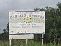
Like the state of Kansas, Carrizo Springs identifies itself with the sunflower, Dimmit County-style
-
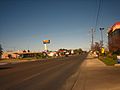
Along U.S. Route 83 in Carrizo Springs
-
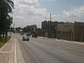
Along U.S. Route 277 in Carrizo Springs
-
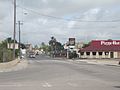
Intersection of Highways 277 (west) and 83 (north) in Carrizo Springs
-
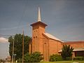
First Baptist Church on Main Street in Carrizo Springs
-
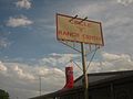
With its display of a large red Justin boot, the Circle V Ranch Center in Carrizo Springs reflects the western culture of the community
-
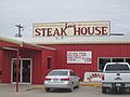
Lee's Steak House off U.S. 83 in Carrizo Springs


See also
 In Spanish: Carrizo Springs para niños
