Cascade Township, Michigan facts for kids
Quick facts for kids
Cascade Township, Michigan
|
|
|---|---|
|
Charter township
|
|
| Cascade Charter Township | |

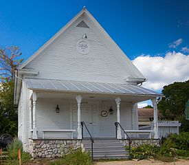
Former township hall in Cascade Township
|
|
| Motto(s):
"Serene vistas... Plentiful trees... Two rivers... One community"
|
|

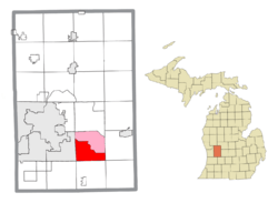
Location within Kent County (red) and an administered portion of the Forest Hills CDP (pink)
|
|
| Country | United States |
| State | Michigan |
| County | Kent |
| Established | 1848 |
| Area | |
| • Total | 34.86 sq mi (90.29 km2) |
| • Land | 33.88 sq mi (87.75 km2) |
| • Water | 0.98 sq mi (2.54 km2) |
| Elevation | 663 ft (202 m) |
| Population
(2020)
|
|
| • Total | 19,667 |
| • Density | 564.17/sq mi (217.820/km2) |
| Time zone | UTC-5 (Eastern (EST)) |
| • Summer (DST) | UTC-4 (EDT) |
| ZIP code(s) | |
| Area code(s) | 616 |
| FIPS code | 26-081-13660 |
| GNIS feature ID | 1626037 |
Cascade Charter Township is a special kind of local government area. It is located in Kent County, in the state of Michigan, USA. In 2020, about 19,667 people lived here.
This township is part of the larger Grand Rapids metropolitan area. It is just east of the city of Grand Rapids. You can also find the Gerald R. Ford International Airport within the township.
Contents
Places in Cascade Township
Cascade Township is home to a few different communities. These are areas where people live and work.
Cascade Community
- Cascade is a community that isn't officially a city or town. It's located where 28th Street and Cascade Road meet.
- This area was first mapped out in 1845 by D. S. T. Weller.
- It even had its own post office for many years, from 1854 until 1910.
Forest Hills Community
- Forest Hills is another community in the township. It's also a "census-designated place" (CDP).
- A CDP is an area that the government defines just for counting people. It helps them collect statistics.
- Forest Hills covers the northern half of Cascade Township. It makes up more than half of the township's land.
- Most of the township's residents, about 12,917 people in 2010, live in Forest Hills.
- This CDP is quite large. It even includes parts of Ada Township to the north.
- Forest Hills is the biggest CDP in Michigan, both in size and population.
History of Cascade Township
Cascade Township has a rich history. It was officially created in 1848. Before that, it was part of Ada Township.
The Whitney Tavern Stand is an important historical building here. It was built in 1853. This building is so special that it's listed on the National Register of Historic Places. This means it's recognized for its historical importance.
Geography and Nature
Cascade Township covers an area of about 34.86 square miles (90.29 square kilometers). Most of this area is land, but about 0.98 square miles (2.54 square kilometers) is water.
The township is in the southeastern part of Kent County. It's about 10 miles (16 km) southeast of Grand Rapids. A major natural feature is the Thornapple River. This river flows through the township, dividing it into eastern and western halves.
Cascade Township shares its borders with several other areas:
- To the west, it borders the city of Kentwood.
- To the north, it borders Ada Township.
- To the east, it borders Lowell Charter Township.
- To the south, it borders Caledonia Charter Township.
Getting Around
Cascade Township is easy to get to, thanks to its transportation options.
Airport
 The Gerald R. Ford International Airport is located in the southwestern part of the township. This is a commercial airport, meaning it handles flights for many people. It covers about 4.89 square miles (12.67 square kilometers) of the township.
Major Roads
- I-96 is a big highway that runs east to west right through the middle of the township.
- M-6 is another highway. It enters the township from the south and ends where it meets I-96.
- M-37 (also known as Broadmoor Avenue) briefly passes through the southwestern corner of the township.
Schools in the Township
Students in Cascade Township attend schools from three different public school districts:
- Caledonia Community Schools serves the southern part of the township.
- Most of the township is served by Forest Hills Public Schools.
- A small eastern part of the township is served by Lowell Area Schools.
There is also a special high school called West Michigan Aviation Academy. It is a charter high school located within the township.
Population Facts
The 2020 United States census counted 19,667 people living in Cascade Township. Here's a look at the different groups of people who live there:
- About 87.1% of the people were White (not Hispanic).
- About 2.8% were Black or African American.
- About 4.0% were Asian.
- About 0.1% were Native American.
- About 2.8% were from two or more races.
- People who identified as Hispanic or Latino made up 4.2% of the population.
Famous People
- Justin Amash is a lawyer and politician. He used to represent Michigan's 3rd district in the United States House of Representatives. He served from 2011 to 2021.
See also
 In Spanish: Municipio de Cascade (Míchigan) para niños
 | Aaron Henry |
 | T. R. M. Howard |
 | Jesse Jackson |


