Cat Tail Brook facts for kids
Quick facts for kids Cat Tail Brook |
|
|---|---|

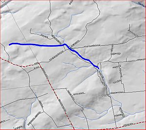
Map of Cat Tail Brook
|
|
| Country | United States |
| Physical characteristics | |
| Main source | 40°26′26″N 74°46′2″W / 40.44056°N 74.76722°W |
| River mouth | 220 ft (67 m) 40°25′55″N 74°43′44″W / 40.43194°N 74.72889°W |
| Basin features | |
| Progression | Rock Brook, Beden Brook, Millstone River, Raritan River, Atlantic Ocean |
| River system | Raritan River system |
Cat Tail Brook is a small stream, also known as a tributary, located in central New Jersey, United States. It flows into a larger stream called Rock Brook. Think of it like a smaller road that connects to a bigger highway.
The Journey of Cat Tail Brook
Cat Tail Brook begins its journey in a hilly area known as Sourland Mountain. This is where the water first starts to gather, forming the beginning of the brook. You can find its starting point at these coordinates: 40°26′26″N 74°46′2″W / 40.44056°N 74.76722°W.
From its source, the brook flows mostly towards the southeast. It travels through the landscape, collecting more water as it goes. Its path takes it along the edge of Sourland Mountain.
The brook's journey ends when it joins Rock Brook. This meeting point is also at the edge of Sourland Mountain, located at 40°25′55″N 74°43′44″W / 40.43194°N 74.72889°W. From there, the water from Cat Tail Brook continues its journey as part of Rock Brook.
Where Does the Water Go Next?
Once Cat Tail Brook joins Rock Brook, its water becomes part of a larger system. This system includes several other streams and rivers:
- First, the water flows into Beden Brook.
- Then, it moves into the Millstone River.
- After that, it joins the Raritan River, which is a major river in New Jersey.
- Finally, the water from Cat Tail Brook reaches the vast Atlantic Ocean.
So, even though Cat Tail Brook is a small stream, its water eventually travels a long way to the ocean!
 | Janet Taylor Pickett |
 | Synthia Saint James |
 | Howardena Pindell |
 | Faith Ringgold |

