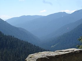
Cayuse Pass facts for kids
Quick facts for kids Cayuse Pass |
|
|---|---|
 |
|
| Elevation | 4,675 ft (1,425 m) |
| Traversed by | State Route 410 |
| Location | Pierce County, Washington, United States |
| Range | Cascades |
| Coordinates | 46°52′01″N 121°32′19″W / 46.86694°N 121.53861°W |
Cayuse Pass is a mountain pass located in the beautiful Cascade Mountains in Washington. It sits high up at an elevation of about 4,675 feet (1,425 m) (which is 4,675 feet). This pass is an important route for travelers and connects different parts of the state.
What is Cayuse Pass?
A mountain pass is like a low spot or a gap between mountains. It makes it easier to travel from one side of a mountain range to the other. Cayuse Pass helps people cross the rugged Cascade Range. It is a popular spot for outdoor activities when the weather is good.
Where is it Located?
Cayuse Pass is found in Pierce County, Washington. It's about 41 miles (66 km) southeast of a town called Enumclaw. Two main roads meet at the pass: State Route 410 and State Route 123. These roads help connect towns like Packwood and Enumclaw.
Winter Closures
Because Cayuse Pass is so high up, it gets a lot of snow in winter. This means the pass usually closes around November each year. It stays closed because of very heavy snow and the danger of avalanches. An avalanche is when a large amount of snow slides down a mountain. The pass typically reopens in mid-May. Sometimes, the snow can be as deep as 15 feet (4.6 m) (15 feet) at the top of the pass!
A Scenic Drive
The road through Cayuse Pass is part of a special route called the Chinook Scenic Byway. This byway is recognized by the U.S. government as an All-American Road. This means it's a very beautiful drive with amazing views of the mountains and forests. It's a great place to visit for sightseeing, especially in the summer and fall.
 | George Robert Carruthers |
 | Patricia Bath |
 | Jan Ernst Matzeliger |
 | Alexander Miles |

