Centennial Range facts for kids
Quick facts for kids Centennial Range |
|
|---|---|
| Highest point | |
| Peak | Centennial Peak |
| Elevation | 3,820 m (12,530 ft) |
| Listing |
|
| Dimensions | |
| Area | 341 km2 (132 sq mi) |
| Geography | |
| Country | Canada |
| Territory | Yukon |
| Range coordinates | 60°58′N 140°39′W / 60.967°N 140.650°W R. Coutts |
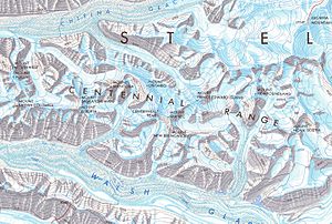
The Centennial Range is a group of mountains in the Saint Elias Mountains. You can find it in Kluane National Park and Reserve in the far west of Yukon Territory, Canada. This range has fourteen main peaks. It was named in 1967 to celebrate Canada's Centennial, which was 100 years since Canada became a country.
Most of the peaks are named after Canada's provinces and territories. However, Nunavut doesn't have a peak because it wasn't a territory back then. The tallest peak in the range is Centennial Peak. In 1967, nine of these peaks were climbed during a special event called the Yukon Alpine Centennial Expedition.
Exploring the Centennial Range Mountains
The Saint Elias Mountains are the highest mountains in Canada. They are also the second highest in North America, right after the nearby Alaska Range. These mountains are located where the borders of Alaska, Yukon Territory, and British Columbia meet.
The Centennial Range is found north of Mount Logan. It is also west of Mount Lucania. The peaks in the Centennial Range are not as tall as some of the mountains around them. No Centennial peak is taller than 4,000 metres (13,000 ft) (about 13,123 feet). But nearby peaks like Mount Steele and Lucania are over 5,000 metres (16,000 ft) (about 16,404 feet) tall. The entire range is inside Kluane National Park and Reserve.
The Centennial Range stretches mostly from east to west. The Walsh Glacier is to its south, and the Chitina Glacier is to its north. The peaks are named after Canada's provinces and territories. This helps you guess where they might be, like a map! For example, Mount Northwest is the farthest west. Mount Nova Scotia is the most eastern peak. As mentioned, Nunavut does not have a mountain. This is because it was not a territory in 1967 when the peaks were named. The highest point in the range is Centennial Peak. It stands tall at 3,820 metres (12,530 ft) (about 12,533 feet).
The Yukon Alpine Centennial Expedition
The Alpine Club of Canada (ACC) was very interested in exploring the Saint Elias range. They had been looking at these remote areas since 1963. The club wanted to plan a big trip to celebrate Canada's 100th birthday. They also wanted to team up with the American Alpine Club. This partnership would also celebrate 100 years since the Alaska Purchase.
The president of the ACC started talking about a mountaineering event in 1965. This event would be part of Canada's centennial celebrations. The Canadian government approved money for the expedition in 1966.
Teams were put together to represent each province and territory. The idea was for each team to have climbers from that specific area. However, not enough people signed up. So, many climbers came from British Columbia, which has lots of mountains. The Centennial expedition was planned for two weeks in late July 1967.
Three main base camps were set up for the climbers. They were called T-Bone, Prairie, and Fundy. Prairie was named after the Canadian Prairies. Fundy was named after the Bay of Fundy.
Climbers from the T-Bone camp tried to reach Mount Northwest, Mount Yukon, and Mount British Columbia. The Prairie camp supported teams climbing Mount Alberta, Mount Saskatchewan, Mount Ontario, and Mount Manitoba. They also climbed Centennial Peak. The teams for Quebec, Prince Edward Island, Newfoundland, and Nova Scotia used the Fundy base camp.
In total, nine of these climbing trips were successful. This was impressive because the climbers were trying new routes. They also had to deal with strong winds and wet weather. Mount Saskatchewan is still unclimbed today.
Main Peaks of the Centennial Range
The peaks are listed from west to east. Heights are from Fisher.
|
|
 | Dorothy Vaughan |
 | Charles Henry Turner |
 | Hildrus Poindexter |
 | Henry Cecil McBay |


