Centerville, Georgia facts for kids
Quick facts for kids
Centerville, Georgia
|
|||||
|---|---|---|---|---|---|
 |
|||||
|
|||||

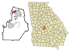
Location in Houston County and the state of Georgia
|
|||||
| Country | United States | ||||
| State | Georgia | ||||
| County | Houston | ||||
| Founded | March 25, 1958 | ||||
| Area | |||||
| • Total | 3.97 sq mi (10.28 km2) | ||||
| • Land | 3.94 sq mi (10.22 km2) | ||||
| • Water | 0.02 sq mi (0.06 km2) 0.58% | ||||
| Elevation | 449 ft (137 m) | ||||
| Population
(2020)
|
|||||
| • Total | 8,228 | ||||
| • Density | 2,085.68/sq mi (805.37/km2) | ||||
| Time zone | UTC-5 (Eastern) | ||||
| • Summer (DST) | UTC-4 (Eastern) | ||||
| ZIP code |
31028
|
||||
| Area code(s) | 478 | ||||
| FIPS code | 13-14920 | ||||
| GNIS feature ID | 0355090 | ||||
Centerville is a city located in Houston County, Georgia, in the United States. It's part of a bigger area called the Macon-Warner Robins Combined Statistical Area. The city was officially started on March 25, 1958.
In 2010, about 7,148 people lived in Centerville. This was a big jump from 4,278 people in 2000. Centerville is known for its great location near major roads and its good quality of life. Because of this, it's considered one of the best "bedroom communities" in Georgia. A bedroom community is a town where many people live and then travel to a nearby city for work. In 2016, Centerville was even ranked as the 7th Happiest City in Georgia!
Contents
Why is it Called Centerville?
You might think Centerville got its name because it's in the very center of Georgia. But that's not true! The city is actually named for its location between two important county seats: Macon (the main city of Bibb County) and Perry (the main city of Houston County). So, it's "center" between those two places.
Where is Centerville Located?
Centerville is in the northern part of Houston County. It's located at 32°37′56″N 83°40′41″W / 32.63222°N 83.67806°W. To the east and south, it shares a border with the city of Warner Robins. To the west, it borders Byron, which is in Peach County.
Roads Around Centerville
U.S. Route 41 runs through the west side of Centerville. This road can take you about 17 miles north to Macon or about 12 miles south to Perry. State Route 247 Connector, also known as Watson Boulevard, forms the southern edge of Centerville. You can take this road east into Warner Robins or about 3 miles west to Interstate 75 at Exit 146.
Size of the City
The United States Census Bureau says that Centerville covers a total area of about 10.3 square kilometers (about 3.97 square miles). A small part of this area, about 0.06 square kilometers (0.02 square miles), is water.
Who Lives in Centerville?
The population of Centerville has grown quite a bit over the years.
| Historical population | |||
|---|---|---|---|
| Census | Pop. | %± | |
| 1960 | 290 | — | |
| 1970 | 1,725 | 494.8% | |
| 1980 | 2,622 | 52.0% | |
| 1990 | 3,251 | 24.0% | |
| 2000 | 4,278 | 31.6% | |
| 2010 | 7,148 | 67.1% | |
| 2020 | 8,228 | 15.1% | |
| U.S. Decennial Census | |||
Population Makeup in 2020
In 2020, there were 8,228 people living in Centerville. These people lived in 2,891 households, and 2,122 of these were families. The table below shows the different groups of people who lived in Centerville in 2020.
| Race | Num. | Perc. |
|---|---|---|
| White (non-Hispanic) | 4,498 | 54.67% |
| Black or African American (non-Hispanic) | 2,291 | 27.84% |
| Native American | 35 | 0.43% |
| Asian | 424 | 5.15% |
| Pacific Islander | 1 | 0.01% |
| Other/Mixed | 450 | 5.47% |
| Hispanic or Latino | 529 | 6.43% |
Getting Around Centerville
Centerville has good ways for people to travel, whether by car or on foot.
Main Roads
The most important roads in and around Centerville include:
- I-75 (Interstate 75)
- GA Highway 247 Connector (also called Watson Blvd)
- GA Highway 41
Walking Paths
In 2012, Centerville started a plan to make its sidewalks better. This plan is still helping to improve places for people to walk safely. In 2017, a project was approved to widen 2 miles of Elberta Road in Centerville. This project also added a turn lane and a sidewalk to that part of the road, making it safer for both drivers and walkers.
Airports Nearby
If you need to fly, Centerville is close to a few airports:
- The largest airport, Hartsfield-Jackson International Airport in Atlanta, is about 93 miles away.
- The Perry–Houston County Airport is closer, about 25 miles from Centerville.
- The Middle Georgia Regional Airport, located in south Macon-Bibb county, is about 8 miles away.
Images for kids
See also
 In Spanish: Centerville (Georgia) para niños
 | James Van Der Zee |
 | Alma Thomas |
 | Ellis Wilson |
 | Margaret Taylor-Burroughs |


