
Central Avenue Corridor facts for kids

Downtown Central Avenue in Phoenix
|
|
| Location | Phoenix |
|---|---|
| North end | 10499 North (near Sunnyslope) |
| South end | 11699 South (in South Mountain Park) |
The Central Avenue Corridor is a very important street in Phoenix, Arizona. It runs north and south through the city. This busy part of Central Avenue is mostly between Camelback Road in the north and McDowell Road in the south. It's one of Phoenix's most used roads.
Many people work here, with almost 60,000 jobs in this area. You can find big banks, tech companies, law firms, and government offices here. This corridor is also a key part of a larger area called Midtown, Phoenix. Midtown is made up of neighborhoods north of downtown Phoenix.
Contents
Central Avenue: A Key Phoenix Road

Central Avenue is right in the middle of Phoenix. It acts as the dividing line for east and west addresses. This means that streets to the east are called "East" and streets to the west are called "West."
Central Avenue goes through many different parts of Phoenix. Some areas have very high property values, like downtown. Further north, you'll see large, old homes in fancy neighborhoods. South of downtown, near South Mountain, there are some older neighborhoods.
Along Central Avenue, you can see all kinds of buildings. There are shops, old warehouses, offices, homes, and many of the city's tall skyscrapers. Many historic neighborhoods and cultural places are also found on or near Central Avenue.
The Story of Central Avenue
Early Days Before World War II

When Phoenix was first founded, Central Avenue was called Center Street. Other north-south roads were named after Native American tribes. In 1877, a map officially showed Central Avenue with its current name. But some people still called it Center Street into the 1930s.
Phoenix's first school was built on Center Street in 1874. It was a small, one-room building. Later, a bigger brick schoolhouse was built. The famous Hotel San Carlos opened on that spot in 1928. It was the first downtown hotel with air conditioning and elevators.
The Phoenix Indian School started in 1891. This is why Indian School Road (at 4100 North) has its name. In 1911, the Sunnyslope area, at the north end of Central Avenue, began to be developed.

By 1917, a long bridge was built over the Salt River. This bridge connected downtown to South Mountain. The Westward Ho building was finished in 1927. It was the city's tallest building for many years.
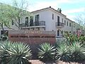
Brophy College Preparatory (4701 North) opened in 1928. The Heard Museum (2301 North) opened in 1929. It became a very important place for learning about Native American culture and history.
Growth in the 1950s
As Phoenix grew north, developers built new places along Central Avenue. Durant's steakhouse (2611 North) opened in 1950. It's still a popular spot today. Park Central Mall (3110 North) was built in the mid-1950s where a dairy farm used to be. This was a sign that shopping was moving away from downtown.
America's second McDonald's restaurant opened near Indian School Road in 1953. It was the first McDonald's franchise and had the famous Golden Arches. This early growth showed how important cars were becoming in Phoenix. The Phoenix Towers (2201 North), a tall apartment building, was built in 1957. The Phoenix Art Museum moved to Central Avenue in 1959.
Skyscrapers of the 1960s

The 1960s brought many new tall buildings to Central Avenue. In 1960, the Phoenix Corporate Center opened. It was the tallest building in Arizona at the time. The first part of the Rozenweig Center, now called Phoenix City Square, was finished in 1964.
The unique Phoenix Financial Center (3443 North) was also completed in 1964. Many other office towers and residential high-rises were built during this decade. These included the Landmark on Central (4750 North) and the Regency On Central (ROC) (2323 North).
Changes in the 1970s

In 1971, Phoenix allowed very tall buildings along Central Avenue. However, not as many new towers were built in this decade compared to the 1960s. Downtown Phoenix became popular again in the 1970s.
In 1979, Phoenix created a plan to divide the city into "urban villages." Each village would have its own center where taller buildings could be built. This plan changed how Phoenix grew, connecting different areas with freeways.
Boom in the 1980s
Building on North Central Avenue picked up again in the 1980s. This was part of a big real estate boom. One Camelback was built in 1985 at the corner of Central and Camelback Road. This building helped shape the skyline of Central Avenue.
The Phoenix Indian School closed in 1988. The city's third-tallest building, Qwest Tower, opened in 1989. It is located in Phoenix Plaza on Thomas Road (2900 North).
Quiet Times in the 1990s

Phoenix tried to make lower Midtown a walkable area with cultural attractions in 1992. But new private buildings didn't happen as expected. The Burton Barr Central Library (1221 North) did open in 1995.
The Viad Tower (1850 North) opened in 1991. It was the last new tall building in Midtown Phoenix for a while. Many older office buildings became empty. The Biltmore area, near 24th Street and Camelback Road, started to become a more popular office area.
New Growth in the 2000s
After many tries, Phoenix voters approved a plan for the METRO Light Rail line. This light rail system opened in late December 2008. It runs along Central Avenue, connecting different parts of the city.

The light rail changed Central Avenue's look and how the neighborhoods around it developed. Phoenix made new rules in 2003 to encourage building near light rail stops. This meant Central Avenue would be less about cars and more about walking and public transport.
New mid-rise buildings like the Artisan Lofts (1326 North) and the Tapestry on Central (2302 North) were built. The Tapestry's construction led to the removal of almost the last old estate home on Central Avenue. The 1917 Ellis-Shackelford House (1242 North) is one of the few remaining.
The Camelback Towers became the Landmark on Central in 2004. Many apartment towers were turned into condominiums where people could own their units. Century Plaza (3225 North) was also remodeled and became "One Lexington."
Steele Indian School Park opened in November 2001. It was built on the site of the old Phoenix Indian School.
Images for kids
-
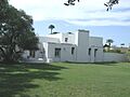
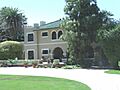
The David Morgan-Earl A. Bronson House was built in 1927 and is located at 8030 N. Central Ave. (NRHP).
-
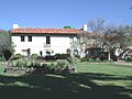
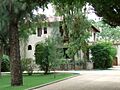
The Asbury-Salmon House was built in 1934 and is located at 7801 N. Central Ave. This house was built by Cline Asbury who managed the Crystal Ice and Cold Storage in Phoenix. The Salmon family lived in the house until 1970. It is listed in the Phoenix Historic Properties Register and the National Register of Historic Places.
-
The Dr. Jean S. Holloway House was built in 1928 and is located 7215 N. Central Ave. It is listed in the Phoenix Historic Properties Register.
-
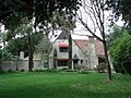
The Halm-Howard House was built in 1906 and is located at 6850 N. Central Ave. It is listed in both the Phoenix Historic Properties Register and the National Register of Historic Places.
-
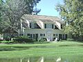
The Olney-Ellinwood House was built in 1912 and is located at 6810 N. Central Ave. It is listed in both the Phoenix Historic Properties Register and the National Register of Historic Places.
-
The John M. Ross House was built in 1926 and is located at 6722 N. Central Ave. John Mason Ross was a partner in a well-known law firm. He was also involved in many civic and political activities in Arizona. It is listed in the National Register of Historic Places.
-
The Ralph Converse House was built in 1935 and is located at 6617 N. Central Ave. It is listed in both the Phoenix Historic Properties Register and the National Register of Historic Places.
-
The Mrs. Leonard George House was built in 1929 and is located at 6611 N. Central Ave. It is listed in the Phoenix Historic Properties Register.
-
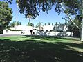
The Abner Elliot England-Guy Hidden Lawrence House was built in 1929 and is located at 6234 N. Central Ave. (NRHP).
-
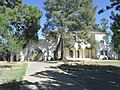
The Judge Fred C. Jacobs House was built in 1928 and is located at 6224 N. Central Ave. (NRHP).
-
The E. Payne Palmer House was built in 1929 and is located at 6012 N. Central Ave. Dr. Errol Payne Palmer was a very important doctor who helped improve hospitals and medical care. He also gave a lot of his time and money to help his community. It is listed in both the Phoenix Historic Properties Register and the National Register of Historic Places.
-
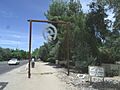
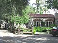
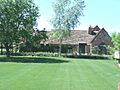
The Murphy Bridle Path starts at Bethany Homes Road and goes north for two and a half miles. This path shows how Phoenix developed in the late 1800s and early 1900s. William John Murphy, who moved to Phoenix in 1883, built the Arizona Canal and started the citrus industry in this area. The path is listed on the Phoenix Historic Property Register.
-
The Brophy College Chapel was built in 1928 and is located at 4701 N. Central Ave. The Chapel was given by Mrs. William Henry Brophy to honor her husband. Students of Brophy College built this Spanish Colonial chapel. It is listed in the National Register of Historic Places.
-
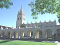
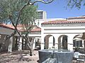
The front entrance of the Heard Museum building. It was built in 1929 and is located at 2301 N. Central Ave. It is listed in the Phoenix Historic Property Register.
-
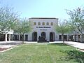
The Heard Museum building was built in 1929 and is located at 2301 N. Central Ave. Maie Heard added many artworks to the museum's collection. She also helped guide the museum's activities and programs. It is listed in the Phoenix Historic Property Register.
-
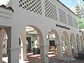
Another view of the Heard Museum.
-
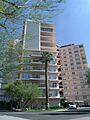
Regency On Central, also known as The Regency House, was built in 1964 and is located at 2323 North Central Ave. It is listed in the National Register of Historic Places.
-
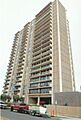
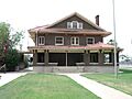
Phoenix Towers was built in 1957 and is located at 2201 N. Central Ave. Phoenix Towers was built as a community where residents owned their homes. It is a great example of architecture from the mid-20th century and is listed in the National Register of Historic Places.
-
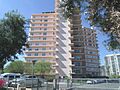
Front view of the Phoenix Towers. The towers were built in 1957 and are located at 2201 N. Central Ave. It is listed in the National Register of Historic Places.
-
The El Encanto Apartment Building was built in 1939 and is located at 2214 N. Central Ave. It was the largest apartment complex in Phoenix at the time. It is listed in the Phoenix Historic Properties Register.
-
The Dr. Shackelford Dental Office Building currently has a small exhibit of the Arizona Street Railway Museum. It is located at 1242 N. Central Ave. (PHPR).
-
The Dr. Ellis House was built in 1917 and is located at 1242 N. Central Ave. (NRHP).
-
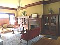
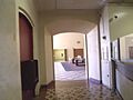
The living room of the Ellis-Shackelford House. The house was built in 1917 and is located at 1242 N. Central Ave. It is listed in the National Register of Historic Places.
-
The C. P. Stephans De Soto Six Motor Cars building was built in 1927 and is located at 915 N. Central Ave. It is listed in the National Register of Historic Places.
-
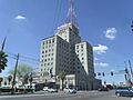
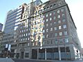
The Westward Ho Hotel was built in 1928 and is located at 618 N. Central Ave. It is listed in the National Register of Historic Places.
-
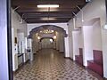
The lobby of the Westward Ho Hotel. The hotel was built in 1928 and is located at 618 N. Central Ave. Many famous people like John F. Kennedy, Marilyn Monroe, and Clark Gable stayed here.
-
The Grand Dining Room of the Westward Ho Hotel. The hotel was built in 1928 and is located at 618 N. Central Ave. Senator John F. Kennedy gave a speech here in 1960. The hotel is listed in the National Register of Historic Places.
-
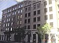
The U.S. Post Office/Federal Building was built between 1932 and 1936. It is located at 522 N. Central Ave. This building is listed in both the Historic Properties in Phoenix Register and the National Register of Historic Places.
-
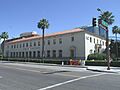
Another view of The U.S. Post Office/Federal Building which was built between 1932 and 1936. It is located at 522 N. Central Ave. It is listed in both the Historic Properties in Phoenix Register and the National Register of Historic Places.
-
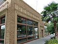
The A.E. England Motors Building was built in 1926 and is located at 424 N. Central Ave. (PHPR)
-
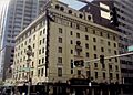
The Security Building was built in 1925 and is located at 234 N. Central Avenue. It is listed in the National Register of Historic Places.
-
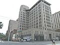
The San Carlos Hotel was built in 1925 and is located at 202 N. Central Ave. Celebrities like Mae West and Marilyn Monroe stayed here. The hotel was added to the National Register of Historic Places in 1983.
-
The Professional Building was built in 1931 and is located at 137 N. Central Ave. It was listed in the National Register of Historic Places in 1993.
-
The Heard Building was built in 1920 and is located at 112 N. Central Ave. It was Phoenix's first skyscraper. The building is listed in the National Register of Historic Places and was even in Alfred Hitchcock's 1960 film "Psycho."
-
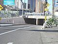
The Central Avenue Underpass was built in 1940. It is on Central Avenue just south of Madison Street in downtown Phoenix. The bridge above was originally for the ATSF railway.
-
The Jefferson Hotel was built in 1915 and is located at 101 S. Central Ave. It is no longer a hotel and is now called the Barrister Place Building. It is home to the Phoenix Police Museum (PHPR).
-
The Pratt-Gilbert Building was built in 1913 and is located at 200 S. Central Ave. It is listed in the Phoenix Historic Properties Register.
-
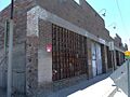
The Anchor Manufacturing Co. building was built in 1925. It is located at 525 S. Central Ave. The building is listed in the National Register of Historic Places.
-
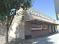
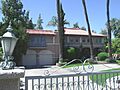
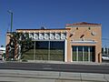
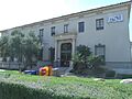
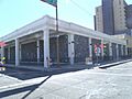
The South Phoenix Market building was built in 1948 and is located at 4341 S. Central Ave. This property is recognized as historic by the City of Phoenix.
-
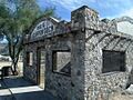
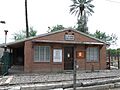
The Scorpion Gulch store was built in 1936 by William Lunsford. It is located at 10225 S. Central Ave. in South Mountain Park. It is listed in the Phoenix Historic Property Register.


_(2).jpg)
A part of this area has been known as Billionaires Row.
