Ceratodus, Queensland facts for kids
Quick facts for kids CeratodusQueensland |
|||||||||||||||
|---|---|---|---|---|---|---|---|---|---|---|---|---|---|---|---|

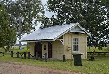
The former Ceratodus railway station, relocated in 1997 to the Burnett Highway rest area; 2017
|
|||||||||||||||
| Population | 34 (2021 census) | ||||||||||||||
| • Density | 0.367/km2 (0.95/sq mi) | ||||||||||||||
| Postcode(s) | 4627 | ||||||||||||||
| Area | 92.7 km2 (35.8 sq mi) | ||||||||||||||
| Time zone | AEST (UTC+10:00) | ||||||||||||||
| LGA(s) | North Burnett Region | ||||||||||||||
| State electorate(s) | Callide | ||||||||||||||
| Federal Division(s) | Flynn | ||||||||||||||
|
|||||||||||||||
Ceratodus is a small, quiet town located in the North Burnett Region of Queensland, Australia. It's a rural area, meaning it's mostly countryside. In 2021, only 34 people lived here! The town is special because its name comes from a very old and unique fish called the Queensland lungfish.
Contents
Where is Ceratodus?
Ceratodus is found right next to the Burnett River. This river flows through the area, and another river, the Nogo River, joins it nearby. The main road that goes through Ceratodus is the Burnett Highway, which helps people travel from the south to the north.
The Story of Ceratodus
How Ceratodus Got Its Name
The town of Ceratodus was named after its railway station. And guess what the railway station was named after? A special fish called the Queensland lungfish (its scientific name is Neoceratodus forsteri). This amazing fish was originally found only in the Burnett River and the Mary River. The railway station was given this name on 4 October 1923.
The Railway Arrives
A railway line, called the Mungar Junction to Monto railway line, opened in Ceratodus on 26 April 1924. This was a big deal for the area! In September 1924, about 100 railway workers were living in Ceratodus. They were busy building bridges and doing other railway work. At that time, there was only one permanent settler, a person named Falconer, living there.
For many years, Ceratodus was an important stop for steam locomotives. These trains needed water, and Ceratodus had a special watering station for them.
Schools and Post Office
Ceratodus had a provisional school that was open from 1925 to 1927. Later, a state school opened in July 1930. The building for this school was actually moved from another town called Towns Creek! This school helped educate the children in the area until it closed on 10 October 1965.
Another school, Nogo River Junction State School, was open from 1927 to about 1941. It was located near where the Nogo River meets the Burnett River.
A small post office opened at the railway station in January 1925. By April 1926, it became a full post office. In 1967, the person who ran the post office also managed the telephone exchange, which only had one phone line! At that time, there were no shops or businesses in Ceratodus, just a couple of railway cottages. The post office closed on 31 May 1968.
Who Lives in Ceratodus?
In 2016, the town of Ceratodus had a population of 28 people. By 2021, the population had grown slightly to 34 people.
Places of Interest
Ceratodus has a special spot listed for its history:
- The Ceratodus Rest Area on the Burnett Highway. This is where the old Ceratodus railway station building was moved in 1997.
 | Mary Eliza Mahoney |
 | Susie King Taylor |
 | Ida Gray |
 | Eliza Ann Grier |


