Cerro Miscanti facts for kids
Quick facts for kids Cerro Miscanti |
|
|---|---|

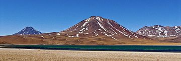
Seen from the Laguna Miscanti, FLTR: Volcán Chiliques, Cerro Miscanti, Cordón Puntas Negras.
|
|
| Highest point | |
| Elevation | 5,622 m (18,445 ft) |
| Geography | |
| Location | Chile |
| Parent range | Andes |
| Geology | |
| Last eruption | Pleistocene |
Cerro Miscanti (also known as Ipira) is a tall mountain in the Antofagasta Region of Chile. It stands just south of another mountain called Chiliques and north of Miñiques. This impressive peak also overlooks the beautiful Laguna Miscanti lake.
The rocks that make up Cerro Miscanti are mostly a type called andesite. Sometimes, rocks that contain andesite, known as dacites, are also found here.
About the Mountain
Cerro Miscanti covers an area of about 38 square kilometers (about 14.7 square miles). Long ago, part of the mountain collapsed towards the west. This collapse showed the inside of the volcano. After this, a new volcano started to grow right inside the collapsed area.
Scientists believe Miscanti might be an extinct volcano, meaning it won't erupt again. However, it might have erupted during the Pleistocene or Holocene periods, which were very long ago. If it were to erupt again, it would likely release lava flows. These lava flows could reach the northern parts of Laguna Miscanti.
Ancient History
An ancient Inka holy place, or sanctuary, has been found on Cerro Miscanti. This shows that the mountain was important to the Inka people many centuries ago.
See also
 In Spanish: Cerro Miscanti para niños
- Miñiques
- Chiliques
- Laguna Miscanti
- Cordón Puntas Negras
- Los Flamencos National Reserve
- Caichinque

