Chiliques facts for kids
Quick facts for kids ChiliquesVolcano in Chile |
|
|---|---|

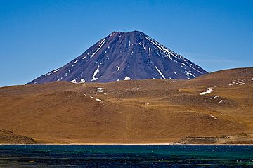
The Chiliques volcano, seen from Laguna Miscanti
|
|
| Highest point | |
| Elevation | 5,778 m (18,957 ft) |
| Geography | |
| Location | Chile |
| Parent range | Andes |
| Geology | |
| Mountain type | Stratovolcano |
| Last eruption | Unknown |
Chiliques is a large stratovolcano located in the Antofagasta Region of Chile. It is part of the mighty Andes mountain range. This volcano stands tall at 5,778 meters (about 18,957 feet) above sea level.
Chiliques is known for its unique summit. It has a wide crater, about 500 meters (1,640 feet) across. Inside this crater, you can find two small lakes. One lake is in the northern part, and the other is in the east-southeast. The volcano is made up of different types of rocks, mostly andesite and dacite.
Contents
How Chiliques Was Formed
The story of Chiliques began with a field of block lava. This lava field can still be seen northeast of the main volcano, stretching for about 6.5 kilometers (4 miles).
Building the Volcano
After the block lava, long lava flows started to build up the main volcano. Some of these flows were up to 10 kilometers (6 miles) long! These flows created the classic cone shape of a stratovolcano. Later, shorter lava flows, up to 5 kilometers (3 miles) long, covered the area around the summit crater. These newer flows cover about 16.26 square kilometers (6.28 square miles).
Is Cerro Overo Part of Chiliques?
There's a small maar called Cerro Overo northeast of Chiliques. A maar is a wide, flat-bottomed volcanic crater. Some people thought it was the last part of Chiliques's activity. However, newer research suggests they are not connected. There is no record of Chiliques erupting in recent history.
Watching Chiliques from Space
Scientists have been keeping an eye on Chiliques from space. They use special satellite images from a tool called ASTER.
What Did ASTER See?
In 2002, the ASTER images showed something interesting: a temperature change on Chiliques. Sometimes, this change was as much as 15 degrees Celsius (27 degrees Fahrenheit). This could mean there were hot spots in the crater lakes or gas vents (called fumaroles). However, it was hard to be sure.
Where Were the Hot Spots?
Some of these warmer spots were seen inside the crater. Others were on the upper slopes of the volcano. This temperature change only lasted for a few months. Later, an expedition went to the crater. They did not find any signs of eruptions or unusual temperatures in the crater lake.
Future Eruptions
If Chiliques erupts again, it will likely be with lava flows. These flows would probably only affect the areas very close to the volcano. However, larger eruptions could impact roads near the Huaytiquina pass and the town of Socaire.
Magma Deep Underground
Scientists have used a method called magnetotellurics to study the ground around Chiliques. This method helps them see what's deep below the surface.
What Did They Find?
They found a zone underground that conducts electricity very well. This zone is located between Chiliques, Cordón de Puntas Negras, and Láscar volcanoes. This high-conductivity zone goes down about 6 kilometers (3.7 miles) deep at its southern end. This could mean there is magma (molten rock) present deep underground.
Water and Routes Around Chiliques
The lake Laguna Lejia is located north of Chiliques volcano. Other parts of the volcano's water flow into the Salar de Atacama, a large salt flat. Chiliques helps form the boundary for the water flowing into this salt flat.
Climbing Chiliques
There is an old route that goes up the mountain. Besides the steep slopes and the high altitude, climbing Chiliques does not present major difficulties.
Chiliques and Local Culture
The town of Socaire is located west of Chiliques. The volcano is very important to the people of Socaire.
A Source of Water and Beliefs
The people of Socaire believe that Chiliques is the source of their water. It is also part of their traditional beliefs about the universe. Chiliques is seen as connected to nearby mountains like Tumisa, Lausa, Ipira, and Miñiques.
Special Sunrise
From Socaire, the sun rises right behind Chiliques on St. Bartholomew's Day. Saint Bartholomew is a very important saint for the town.
Ancient Discoveries on the Volcano
Archaeologists have found interesting things on Chiliques. They discovered pottery, a stone room, and an oval-shaped structure near the summit. There are also platforms and other stone structures lower down the slopes. Even further down, they found an Incan tambo, which was a type of resting place or storage building used by the Inca people. Finding ancient sites on mountains is common in Chile. Other examples include Licancabur and Cerro Quimal, which also have such structures.
See also
 In Spanish: Chiliques para niños

