Tumisa facts for kids
Quick facts for kids Tumisa |
|
|---|---|
| Cerro Tumisa | |

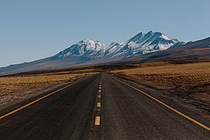
View of Tumisa (left) and Lejía volcano (right)
|
|
| Highest point | |
| Elevation | 5,658 m (18,563 ft) |
| Geography | |
| Parent range | Andes |
| Geology | |
| Age of rock | Pleistocene |
| Mountain type | Stratovolcano |
| Volcanic belt | Central Volcanic Zone |
| Last eruption | 500,000 years ago |
Tumisa (also called Cerro Tumisa) is a large, cone-shaped volcano in the Andes mountains. It formed a long time ago, during the Pleistocene Ice Age. Tumisa is located east of a huge salt flat called the Salar de Atacama. It's part of a bigger area of volcanoes known as the Central Volcanic Zone. This area has seen many eruptions of lava and ash over millions of years. Tumisa sits on top of very old rocks and other volcanic materials from nearby volcanoes.
Contents
What is Tumisa Made Of?
This composite volcano is built from different types of volcanic material. These include slow-moving flows of rock blocks, fast-moving lava flows, and dome-shaped piles of lava called lava domes. There are also some ash and rock fragments called ignimbrites, which are made of light, bubbly rock called pumice.
More than six lava domes and two main cones make up Tumisa. They are surrounded by a wide blanket of volcanic ash and rock, known as a pyroclastic apron. This apron covers about 300 square kilometers (116 square miles). It was formed by many fast-moving flows of hot gas and volcanic debris, called pyroclastic flows. These flows contained pumice and large rock pieces. Some of these rocks were still hot and soft when they landed, so they got squished and deformed.
The lava domes and lava flows of Tumisa are grouped into three main parts. Scientists believe that Tumisa's activity started with huge explosive eruptions. These eruptions created the wide apron of volcanic ash. Later, the magma (melted rock) inside the volcano lost some of its gas. This less gassy magma then formed the lava domes and lava flows.
How Did Tumisa Change Over Time?
Scientists have studied the age of the volcano's rocks. They found that the rocks higher up on the volcano are younger. This pattern might mean that the volcano's underground magma system moved over time. Another idea is that the volcano slowly slid downhill over its history. This sliding happened at a speed of about 0.5 to 2 centimeters (0.2 to 0.8 inches) per year.
Tumisa grew on top of soft lake sediments. These sediments made it easier for the volcano to slide. The way the volcano's rivers and streams flow also supports this idea. The channels bend outwards and curve towards the west. These channels might have formed over cracks in the sliding volcano.
Deep valleys, called quebradas, were carved into Tumisa's northern side less than a million years ago. This happened during cold periods when glaciers were present on the mountain. You can also find piles of rock and dirt left behind by glaciers, called moraines. These moraines show that glaciers once covered parts of the mountain, reaching down to about 4,900 meters (16,076 feet) high.
What Are Tumisa's Rocks Like?
The volcano has erupted a type of lava called dacitic lava. This lava often contains darker, more basic rock pieces called andesitic mafic inclusions. These small rock pieces are similar to those found in the nearby Lascar volcano. Some of Tumisa's rocks might have changed because the magma mixed with calcium carbonate deep inside the volcano.
The rocks also contain crystals. There are hornblende crystals that are about 5 to 10 millimeters (0.2 to 0.4 inches) long. There are also very large feldspar crystals, called megacrysts, which can be up to 1.5 centimeters (0.6 inches) long. The way these rocks look suggests that different types of magma mixed together during the eruptions. The dacite rocks often look white and have visible crystals, which is called a porphyritic texture.
The main group of lava domes formed between 2.5 and 0.5 million years ago. The ash and rock fragments around them formed between 1.5 and 0.5 million years ago. These volcanic features were built on top of even older volcanic rocks. One specific dome, called Las Mulas, has been dated to about 1.2 million years old. All these features show that Tumisa was active during the Pleistocene period. After the eruptions, hot water and chemicals changed some of the rocks, a process called hydrothermal alteration.
Nearby Features and Local Stories
A crack in the Earth's crust, called a fault, crosses Lejía Lake near Tumisa. This fault might still be active today. It connects Tumisa to a small, flat-bottomed volcanic crater called a maar, and another isolated lava dome. This fault runs from the northwest to the southeast and crosses the southern edge of Lejía Lake.
On Tumisa's eastern side, there is an old sulfur mine that has been abandoned. A road leads up to it. The people of Socaire, a nearby town, have a special way of seeing Tumisa and its neighboring mountains. They believe Tumisa, along with Lausa, Chiliques, Ipira, and Miñiques, form a giant human left hand on the eastern horizon. This giant hand is said to be about 40 by 30 kilometers (25 by 19 miles) in size.
See also
 In Spanish: Tumisa para niños


