Chachapoyas facts for kids
Quick facts for kids
Chachapoyas
|
|||
|---|---|---|---|
|
City
|
|||
|
|||
| Country | |||
| Region | Amazonas | ||
| Province | Chachapoyas | ||
| District | Chachapoyas | ||
| Founded | September 5, 1538 | ||
| Founded by | Alonso de Alvarado | ||
| Area | |||
| • Total | 12.3 km2 (4.7 sq mi) | ||
| Elevation | 2,335 m (7,661 ft) | ||
| Population
(2017)
|
|||
| • Total | 32,026 | ||
| • Estimate
(2015)
|
29,869 | ||
| • Density | 2,604/km2 (6,744/sq mi) | ||
| Time zone | UTC-5 (PET) | ||
| Postal code |
477002
|
||
| Climate | Cfb | ||
| Website | www.munichachapoyas.gob.pe | ||
Chachapoyas is a city high up in the mountains of northern Peru. It's about 2,335 meters (7,661 feet) above sea level. In 2017, about 32,026 people lived there. Because it's in the mountains, far from the coast, Chachapoyas has been quite isolated. You can reach it by bus from Chiclayo and Cajamarca, or by flying into Chachapoyas Airport.
Chachapoyas is the capital of the Amazonas Region. It was founded on September 5, 1538, by a Spanish explorer named Alonso de Alvarado. Farmers in the area grow things like sugar cane, beautiful orchids, and coffee. The city gets a moderate amount of rain because it's located between dry mountains and rainy rainforest areas.
Contents
History of Chachapoyas
How the City Was Founded
The city was first named San Juan de la Frontera de los Chachapoyas. It was built in a few different spots, like near La Jalca and Levanto. These early locations were left because of bad weather, sickness, and attacks from local groups. The city finally settled in its current location, which is 2,334 meters high. It's believed the Spanish moved the city to this spot around 1545.
Chachapoyas Today
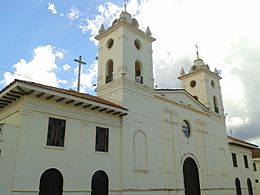
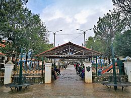
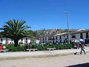
Even now, the city has many old colonial houses called casonas. These houses have large courtyards and living rooms, with roofs made of tiles. The main square, called the Plaza de Armas, is a perfect square, 100 meters on each side. On the south side of the square, there's a monument to a hero named Francisco Bolognesi.
Old Legends of the City
From the time Peru was a Spanish colony, there's a legend about an Indian chief named Pantoja. He supposedly asked the viceroy (a ruler representing the king) for permission to put a gold roof on his house! This and other treasures are said to be hidden in one of the 40 caves around the city.
Long ago, there was a lagoon near where the Kuélap stadium is now. It was surrounded by plants like totoras (a type of bulrush) and palm trees. People used wood from these plants to build the city's temples.
Geography and Climate
Where is Chachapoyas?
To get to Chachapoyas, you follow the Utcubamba River from the Bagua area. Until recently, the city was quite isolated because of its location. But now, better roads connect Chachapoyas to cities on Peru's northern coast.
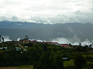
The city is surrounded by thick forests. During the rainy season, these forests are often covered in a thick mist. This might be how the city got its name! Some people think "Chachapoyas" comes from the Quechua word sachapuyos, meaning "mount of haze." Others believe it means "strong male."
What is the Climate Like?
Chachapoyas is located in a part of Peru known as the "eyebrow of the jungle." This means it's a humid, subtropical highland area. The climate is described as Cfb by the Köppen climate classification. The average temperature is about 18 °C (64 °F), and the air is usually 74 percent humid. Sometimes, the temperature can drop to 2 °C (36 °F).
Chachapoyas has a mild and moderately rainy climate. The average highest temperature between 1960 and 1991 was 19.8 °C (67.6 °F), and the average lowest was 9.2 °C (48.6 °F). The city gets about 777.8 mm (30.6 inches) of rain each year.
The street called Jiron Triunfo connects the city's three main squares. It's named "Triunfo" (Triumph) because the victorious Chachapoyans entered the city through this street after the Higos Urco battle.
| Climate data for Chachapoyas, Peru (1961–1990) | |||||||||||||
|---|---|---|---|---|---|---|---|---|---|---|---|---|---|
| Month | Jan | Feb | Mar | Apr | May | Jun | Jul | Aug | Sep | Oct | Nov | Dec | Year |
| Mean daily maximum °C (°F) | 20.1 (68.2) |
19.7 (67.5) |
19.7 (67.5) |
19.9 (67.8) |
20.1 (68.2) |
19.6 (67.3) |
19.3 (66.7) |
19.8 (67.6) |
20.0 (68.0) |
20.4 (68.7) |
20.8 (69.4) |
20.7 (69.3) |
20.0 (68.0) |
| Mean daily minimum °C (°F) | 9.7 (49.5) |
9.9 (49.8) |
10.0 (50.0) |
9.9 (49.8) |
9.5 (49.1) |
8.6 (47.5) |
7.8 (46.0) |
7.9 (46.2) |
8.7 (47.7) |
9.6 (49.3) |
9.4 (48.9) |
9.5 (49.1) |
9.2 (48.6) |
| Average precipitation mm (inches) | 86.6 (3.41) |
96.2 (3.79) |
121.2 (4.77) |
86.8 (3.42) |
43.5 (1.71) |
28.2 (1.11) |
18.6 (0.73) |
33.5 (1.32) |
48.3 (1.90) |
87.8 (3.46) |
86.6 (3.41) |
73.9 (2.91) |
811.2 (31.94) |
| Source: NOAA | |||||||||||||
Fun Places to Visit
Independence Square
East of the city is Independence Square. Here, you'll find a monument honoring the heroes of Chachapoyas from the Higos Urco battle on June 6, 1821. Plaza Santa Ana is said to have been the city's first square. The first church in Chachapoyas was built here. People used to celebrate the San Juan de los Indios' festivities in this square with eight days of bullfighting.
Luya Urco Hill and Yana Yaku Well
Luya Urco is a hill west of the city. On this hill is the well of Yana Yaku, also known as the Fuente Cuyana. This well was built where, according to a legend, a saint named Santo Toribio de Mogrovejo made water come out of a rock. This ended a terrible drought in the area. The legend says that any man who drinks from this well will be forever charmed by the women of Chachapoyas!
Cuyana Fountain Legend
This legendary fountain was on the side of Luya Urco hill. It had two water jets, one for good and one for evil. The legend says that if you drank from the first jet, you would find love. But if you drank from the second, you would feel hate or indifference. People in the city used to say that any visitor who drank from this "fountain of love" would be forever captivated by the city's beautiful women and wonderful surroundings.
Petroglyphs of Pitaya
About 20 kilometers (12 miles) from Chachapoyas, in the Huancas district, you can find an amazing archaeological site. It has petroglyphs (rock carvings) that are about 3,000 years old! There are about 30 different pictures showing plants and animals. Some even show scenes of hunting.
To get there, you travel about 9 kilometers (20 minutes) north from Chachapoyas to the Huancas district. Then, you'll need to walk for about an hour to reach the famous Petroglyphs of Pitaya. It's free to enter this site.
|
See also
 In Spanish: Chachapoyas (desambiguación) para niños
 | Laphonza Butler |
 | Daisy Bates |
 | Elizabeth Piper Ensley |


