
Chalco de Díaz Covarrubias facts for kids
Quick facts for kids
Chalco de Díaz Covarrubias
|
||
|---|---|---|
|
Town & Municipality
|
||

Church
|
||
|
||
| Motto(s):
Government that listens and resolves
|
||

Chalco location in State of Mexico
|
||

Communities in Chalco municipality
|
||
| Country | ||
| State | ||
| Region | Amecameca | |
| Metro area | Greater Mexico City | |
| Municipal Status | January 30, 1824 | |
| Municipal Seat | Chalco de Díaz Covarrubias | |
| Government | ||
| • Type | Ayuntamiento | |
| Area | ||
| • Land | 219.22 km2 (84.64 sq mi) | |
| • Water | 0.00 km2 (0 sq mi) | |
| Elevation
(of seat)
|
2,240 m (7,350 ft) | |
| Population
(2010)
|
||
| • Municipality | 310,130 | |
| Time zone | UTC-6 (CST) | |
| • Summer (DST) | UTC-5 (CDT) | |
| Postal code (of seat) |
56600
|
|
| Area code(s) | 55 | |
| Demonym | Chalquense | |

Chalco de Díaz Covarrubias (Nahuatl pronunciation: [ˈt͡ʃaːɬko]) is a city in the eastern part of the State of Mexico. It is the main town of the surrounding Chalco municipality. Chalco is located just east of Mexico City and is part of the larger Mexico City metropolitan area.
The name Chalco comes from the Nahuatl language. It combines Chalchihuitl, meaning "green stone" or "jade", and Co, meaning "place". So, Chalco means "the place of jade".
The second part of the name, Díaz Covarrubias, honors Juan Díaz Covarrubias. He was a doctor and a hero who was shot in Tacubaya in 1859.
Contents
History of Chalco
Early Settlements
The first Native American group to arrive in the Chalco region was the "Acxotecas." They came from Tula, an ancient city of the Toltec people. The first town they settled was called Chalco.
Later, another group called the Mihuaques arrived. Around 1160 A.D., the Teotenancas and Chichimecas came from the Toluca valley. They traveled through Tláhuac. Other groups, like the Cuixocas, Temimilolcas, and Ihuipanecas, also lived around the lake. These groups all joined together with the Chalcas.
By 1354, the whole region was known as "Tzacualtitlán-Tenanco Amaquemeca-Chalco." By 1410, the Chalca territory was like a group of states. It had four main areas: Acxotlan-Chalco, Tlalmanalco-Amaquemecan, Tenanco-Tepopollan, and Xochimilco-Chimalhuacan. Acxotlan-Chalco was the main one.
Wars were common for expanding territory. For example, in 1376, there was an eight-year "flower war" between the Mexicans and the Chalco people. Many Chalca people died in this battle. Because of this long fight, the Chalco region did not become as grand as Texcoco or Tenochtitlan.
Spanish Arrival
There are different stories about how Hernán Cortés arrived in the Chalco region. One story says that the Chalcas knew Cortés was in Tlaxcala and Cholula. They waited for him near the volcanoes and brought him gifts of gold. Another story says the Chalcas met Cortés in Texmelucan and gave him jewelry, valuable stones, and blankets.
Cortés wrote in a letter that he started from an Amecameca town in the Chalco province. Along the way, he met messengers from Moctezuma. They asked him to go back or wait for Moctezuma's orders. Cortés stayed two days in Amecameca, where he received food, gold, and enslaved people.
Another historian, Clavijero, wrote that Cortés went from Amecameca to Ayotzingo. The leader Cacamac welcomed the Spanish in Ayotzingo. He gave them supplies and offered the city of Texcoco if they would leave.
The Chalcas later allied with the Spanish to protect themselves from the Mexica (Aztecs). This formed a group of different tribes against the Aztecs. After the Aztecs were defeated, the Chalcas regained control of their land. They helped the Spanish in their expeditions.
Colonial Times and Independence
After the Spanish conquest, land was given to the conquerors. In 1533, Chalco became a royal province. It was very important for growing corn, wheat, and other crops. It also produced wood, charcoal, fruits, and building materials. Chalco had busy docks where boats carried vegetables and seeds to Mexico City.

In the 19th century, Mexico became independent. In 1824, the Free and Sovereign State of Mexico was formed. Chalco became part of this new state.
In 1861, the main town of Chalco was named a "villa" (a small city). It was given the name "Diaz Covarrubias" to honor Juan Diaz Covarrubias, a medical student killed in 1859. Chalco also hosted a meeting between Emperor Maximilian and Empress Carlota Amalia.
Modern Chalco
During the time of President Porfirio Díaz (late 1800s), Chalco became a busy trading center. Boats and steamboats continued to connect it to other places. Industries grew, and goods were produced. In 1895, Lake Chalco was drained, and the land was used for farming. This caused the local fishermen to lose their jobs.
In 1890, President Porfirio Díaz laid the first stone for the City Hall, which opened in 1893.
During the Mexican Revolution in 1910, Chalco saw some fighting between Zapata's and Carranza's forces. Churches were damaged, and people suffered.
In 1979, on the dried-up land of Lake Chalco, a very large settlement called Valle de Chalco began to grow. It quickly had over 500,000 people. Because of this growth, Chalco de Díaz Covarrubias was officially made a city in March 1989. In 1994, the people of Valle de Chalco fought to become their own municipality, and so Valle de Chalco Solidaridad was created.
Today, a major employer in Chalco is the San Rafael paper factory.
The Municipality of Chalco


The Chalco municipality covers an area of about 234.72 square kilometers (90.626 sq mi). In 2010, it had a population of 310,130 people.
Chalco is sometimes confused with the Valle de Chalco Solidaridad municipality because both names include "Chalco." The main difference is that Valle de Chalco Solidaridad is located near the old Lake Chalco. However, the two areas are connected by a road called Avenida Solidaridad.
Towns and Villages
Chalco is one of only a few municipalities in Mexico that have many towns with over 10,000 people. The largest towns and villages in Chalco are:
| Name | 2010 Census Population |
|---|---|
| Chalco de Díaz Covarrubias | 168,720 |
| San Martín Cuautlalpan | 23,501 |
| San Mateo Huitzilzingo | 15,389 |
| San Gregorio Cuautzingo | 13,138 |
| Santa María Huexoculco | 12,456 |
| San Marcos Huixtoco | 12,229 |
| San Juan Tezompa | 11,819 |
| San Pablo Atlazalpan | 11,236 |
| Santa Catarina Ayotzingo | 10,702 |
| Total Municipality | 310,130 |
Transportation
Chalco has a public transportation system that uses Volkswagen vans, often called "combis" or "colectivos." These vans take people from the municipality to the edge of Mexico City. From there, people can take the subway into the city center. Some colectivos also go directly from Chalco to Mexico City's Benito Juárez International Airport.
Notable People
- Antonio Pujol (1913–1995), a famous painter.
Images for kids
-
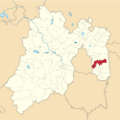
Chalco location in State of Mexico
-
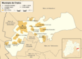
Communities in Chalco municipality
See also
 In Spanish: Chalco de Díaz Covarrubias para niños
