Champlain (village), New York facts for kids
Quick facts for kids
Champlain, New York
|
|
|---|---|

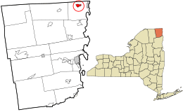
Location in Clinton County and the state of New York.
|
|
| Country | United States |
| State | New York |
| County | Clinton |
| Town | Champlain |
| Named for | Samuel de Champlain |
| Area | |
| • Total | 1.49 sq mi (3.87 km2) |
| • Land | 1.46 sq mi (3.77 km2) |
| • Water | 0.04 sq mi (0.09 km2) |
| Elevation | 105 ft (32 m) |
| Population
(2020)
|
|
| • Total | 1,170 |
| • Density | 803.02/sq mi (309.98/km2) |
| Time zone | UTC-5 (EST) |
| • Summer (DST) | UTC-4 (EDT) |
| ZIP code |
12919
|
| Area code(s) | 518 |
| FIPS code | 36-13739 |
| GNIS feature ID | 0946361 |
Champlain is a small village located in Clinton County, New York, United States. In 2020, about 1,170 people lived there. The village is part of the larger town of Champlain. It's about 4 miles (6.4 km) west of Lake Champlain and north of the city of Plattsburgh.
History of Champlain
The village and the nearby lake are both named after Samuel de Champlain. He was an explorer who first explored this area in 1609. At first, this region was part of Canada, which was controlled by France.
In 1763, it became part of Great Britain. Then, in 1783, it officially became part of the United States. Champlain played an important role in the War of 1812. It was a key spot where soldiers and supplies were gathered for battles. The village of Champlain was officially formed in 1873.
Geography of Champlain
Champlain village is in the northern part of the town of Champlain. It is located at 44°59′12″N 73°26′47″W / 44.986678°N 73.446373°W. Interstate 87, also known as the Adirondack Northway, runs along the western side of the village. You can get to the village from exits 42 and 43.
The city of Montreal in Canada is about 41 miles (66 km) north. Plattsburgh is about 22 miles (35 km) south. US 9 goes through the village. It connects with US 11 just south of the village.
The village covers a total area of about 1.4 square miles (3.7 square kilometers). Most of this area is land, with a small part being water. Champlain is west of Lake Champlain and very close to the border with Quebec, Canada. The Great Chazy River flows through the village on its way to Lake Champlain.
People in Champlain
| Historical population | |||
|---|---|---|---|
| Census | Pop. | %± | |
| 1870 | 1,850 | — | |
| 1880 | 1,509 | −18.4% | |
| 1890 | 1,275 | −15.5% | |
| 1900 | 1,311 | 2.8% | |
| 1910 | 1,280 | −2.4% | |
| 1920 | 1,140 | −10.9% | |
| 1930 | 1,197 | 5.0% | |
| 1940 | 1,354 | 13.1% | |
| 1950 | 1,505 | 11.2% | |
| 1960 | 1,549 | 2.9% | |
| 1970 | 1,426 | −7.9% | |
| 1980 | 1,410 | −1.1% | |
| 1990 | 1,273 | −9.7% | |
| 2000 | 1,173 | −7.9% | |
| 2010 | 1,101 | −6.1% | |
| 2020 | 1,170 | 6.3% | |
| U.S. Decennial Census | |||
According to the census from 2000, there were 1,173 people living in Champlain. There were 521 households and 309 families. The population density was about 837 people per square mile (323 people per square kilometer).
Most of the people living in the village were White (97.19%). A small number of people were Black, Native American, or Asian. About 1% of the population was Hispanic or Latino.
About 29% of households had children under 18 living with them. The average household had 2.23 people. The average family had 2.91 people.
Education
Students in Champlain attend schools within the Northeastern Clinton Central School District.
See also
 In Spanish: Champlain (villa) para niños

