
Charlevoix South Pier Light Station facts for kids
.jpg) |
|
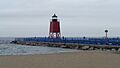
| Charlevoix South Pier Light Station (July 2019) | |

Charlevoix South Pier Light Station
Location in Michigan
|
|
| Location | S pier at harbor entrance, 0.3 WNW of US 31 drawbridge, Charlevoix County, Michigan |
|---|---|
| Coordinates | 45°19′22″N 85°16′11″W / 45.32278°N 85.26972°W |
| Year first constructed | 1948 |
| Foundation | pier |
| Construction | steel skeletal tower, upper 2/3 enclosed |
| Tower shape | Square pyramid tower, decagonal lantern |
| Markings / pattern | red Daymark/black lantern |
| Height | 44 feet (13 m) |
| Original lens | Fifth order Fresnel Lens |
| Current lens | 12-inch (300 mm) Tideland Signal ML-300 acrylic lens |
| Range | 10 nautical miles (19 km; 12 mi) |
| Characteristic | Flashing Red 4s
HORN: 1 blast ev 30s (3s bl). Operates from May 1 to Oct. 20. |
| ARLHS number | USA-156 |
| USCG number | 7-17925 |
The Charlevoix South Pier Light Station is a lighthouse in Michigan, a state in the United States. It stands on Lake Michigan at the entrance to Lake Charlevoix. You can find it at the end of the south pier in the city of Charlevoix. This lighthouse helps guide ships safely into the harbor.
Contents
History of the Charlevoix Light
A Guiding Light: Early Days

The very first lighthouse in Charlevoix was built in 1884. It was located on the north pier. Its job was to guide ships into the Pine River channel. A lifesaving station was also built nearby in 1898. This station helped people who were in trouble on the water. The first lighthouse tower was about 56 feet (17 meters) tall.
A New Lighthouse for Safety
The original lighthouse lasted for 63 years. But by 1947, it was getting old and needed to be replaced. So, in 1948, a new steel lighthouse was built. The light and lantern from the old tower were moved to this new one. This new lighthouse was placed on the south pier, where it stands today. It was first painted red.
Stronger Piers and Water Flow
In 1989, the old wooden pier was replaced with a new one made of steel and concrete. These new piers were built to be very strong. They can stand up to powerful waves. They also have a special design to protect the harbor.
The Pine River Channel is unique because water flows both in and out. After big storms, water from Lake Charlevoix can flow back out to Lake Michigan. This can create small whirlpools and choppy water near the harbor entrance.
Modern Light and Recognition


Today, the lighthouse uses a modern acrylic lens. This lens can shine its light up to 10 nautical miles (about 11.5 miles or 18.5 kilometers).
The Charlevoix South Pierhead Light is an important landmark. It was added to the National Register of Historic Places in 2005. This means it is recognized as a significant historical structure. Even though no one lives in the lighthouse, it is still a very important aid for ships.
In 2009, the lighthouse was painted red again. This color helps sailors remember a rule: "Red Right Returning." This means that when you are returning to a harbor, red markers should be on your right side.
A main ship that uses this light is the Beaver Island ferry. This ferry carries people and supplies to Beaver Island.
The old house where the lighthouse keeper lived was sold and taken down. Now, that area is a park called Hoffman Park.
In 2008, the lighthouse was officially given to the City of Charlevoix and the Charlevoix Historical Society. This happened under a special law called the National Historic Lighthouse Preservation Act. This law helps protect old lighthouses.
Images for kids
-
Charlevoix South Pier Light Station (July 2019)
