Chatham (village), New York facts for kids
Quick facts for kids
Chatham, New York
|
|
|---|---|

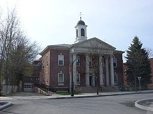
Tracy Memorial Village Hall, April 2009
|
|

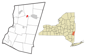
Location of Chatham, New York
|
|
| Country | United States |
| State | New York |
| County | Columbia |
| Towns | Chatham, Ghent |
| Area | |
| • Total | 1.24 sq mi (3.21 km2) |
| • Land | 1.24 sq mi (3.20 km2) |
| • Water | 0.00 sq mi (0.01 km2) |
| Elevation | 463 ft (141 m) |
| Population
(2020)
|
|
| • Total | 1,529 |
| • Density | 1,236.05/sq mi (477.29/km2) |
| Time zone | UTC-5 (Eastern (EST)) |
| • Summer (DST) | UTC-4 (EDT) |
| ZIP code |
12037
|
| Area code(s) | 518 |
| FIPS code | 36-14003 |
| GNIS feature ID | 0946448 |
Chatham /ˈtʃætəm/ is a small village located in Columbia County, New York, United States. In 2020, about 1,529 people lived here.
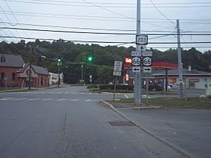
The village of Chatham is special because it sits right on the border between two towns: Chatham and Ghent. You can find it where two main roads, Route 66 and Route 203, meet.
Contents
History of Chatham Village
Chatham became an official village in 1869. Before that, it was known by a different name: Groats Corners. One of the oldest buildings in the village is the Blinn-Pulver Farmhouse, which was built way back in 1814.
Chatham has many fun places to visit. The Crandell Theater is a popular movie theater where you can watch films for a good price. The village is also home to the Columbia County Agricultural Society. They host the yearly Columbia County Fair, which is a big event!
Another exciting place is the Mac-Hadyn Theater. This is a special kind of theater called a summer stock theater. It means they put on Broadway-style shows during the summer, from May to September. A very famous actor, Nathan Lane, used to perform there when he was starting his career.
Two important buildings in Chatham are the Tracy Memorial Village Hall Complex and Union Station. These buildings are so important that they are listed on the National Register of Historic Places. This means they are recognized for their historical value.
Where is Chatham? (Geography)
Chatham is located at coordinates 42°21′43″N 73°35′58″W / 42.36194°N 73.59944°W. The northern part of the village, including its main shopping area, is in the town of Chatham. The southern part of the village is in the town of Ghent.
The village covers about 1.24 square miles (3.2 square kilometers) of land. Only a tiny bit, about 0.004 square miles (0.01 square kilometers), is water. Chatham is built along a waterway called Stony Kill. This stream makes a U-shape through the village. It then flows north into Kinderhook Creek, which eventually joins the Hudson River.
Chatham's Population (Demographics)
| Historical population | |||
|---|---|---|---|
| Census | Pop. | %± | |
| 1870 | 1,387 | — | |
| 1880 | 1,765 | 27.3% | |
| 1890 | 1,912 | 8.3% | |
| 1900 | 2,018 | 5.5% | |
| 1910 | 2,251 | 11.5% | |
| 1920 | 2,710 | 20.4% | |
| 1930 | 2,424 | −10.6% | |
| 1940 | 2,254 | −7.0% | |
| 1950 | 2,304 | 2.2% | |
| 1960 | 2,426 | 5.3% | |
| 1970 | 2,239 | −7.7% | |
| 1980 | 2,001 | −10.6% | |
| 1990 | 1,920 | −4.0% | |
| 2000 | 1,758 | −8.4% | |
| 2010 | 1,770 | 0.7% | |
| 2020 | 1,529 | −13.6% | |
| U.S. Decennial Census | |||
In 2000, there were 1,758 people living in Chatham. The population has changed over the years, as you can see in the chart above. By 2020, the number of people living in the village was 1,529.
Getting Around (Transportation)
Chatham is a small village, and it only has one traffic light! At this intersection, you are allowed to turn right on a red light. The village also has 49 stop signs, 11 yield signs, and one traffic circle. There are also many signs (121 of them!) to help people with parking.
Years ago, the traffic circle on Main Street had an unusual rule. Cars entering the circle had to yield to cars already inside. This was changed in 2008 to follow New York state traffic laws. Now, it works like most traffic circles.
The New York State Department of Transportation (NYSDOT) helped pay for big improvements to Main Street. They installed new water pipes, drainage systems, and sidewalks. Main Street was closed for a while during this work. The project also included repaving side streets and building a new wall on Hudson Avenue. This work happened in 2008 and 2009.
Chatham was once a very important center for several railroads. These included the New York Central, Boston and Albany, and Rutland railroads. It had special track layouts called wyes and a building for trains called a roundhouse.
Fun Events in Chatham
Chatham hosts several exciting events throughout the year:
- Columbia County Fair: This big fair takes place in late August or early September. It includes a special parade for firefighters.
- Fairgrounds Auto Show: Car lovers can enjoy this show in the spring, usually in late May.
- Civil War Reenactment: In the summer, you can watch a reenactment of historical Civil War battles.
Famous People from Chatham
Some notable people have connections to Chatham:
- George McClellan: He was a US congressman.
- Sanford W. Smith: He served as a New York Senator and a New York State Supreme Court Justice.
See also
 In Spanish: Chatham (villa) para niños
 | Isaac Myers |
 | D. Hamilton Jackson |
 | A. Philip Randolph |


