Cherry Creek, Colorado facts for kids
Quick facts for kids
Cherry Creek, Colorado
|
|
|---|---|
 |
|

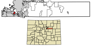
Location of the Cherry Creek CDP in Arapahoe County, Colorado.
|
|
| Country | |
| State | |
| County | Arapahoe County |
| Government | |
| • Type | unincorporated community |
| Area | |
| • Total | 1.669 sq mi (4.322 km2) |
| • Land | 1.669 sq mi (4.322 km2) |
| • Water | 0 sq mi (0.000 km2) |
| Elevation | 5,745 ft (1,751 m) |
| Population
(2020)
|
|
| • Total | 11,488 |
| • Density | 6,884.3/sq mi (2,658.0/km2) |
| Time zone | UTC-7 (MST) |
| • Summer (DST) | UTC-6 (MDT) |
| ZIP Code |
80111
|
| Area codes | 303 & 720 |
| GNIS feature | Cherry Creek CDP |
Cherry Creek is a special kind of community in Colorado, United States. It's called an "unincorporated community" and also a "census-designated place" (CDP). This means it's not officially a city or town, but it's a recognized area where people live. It's located in Arapahoe County.
Cherry Creek is part of a larger area called the Denver–Aurora–Lakewood, CO Metropolitan Statistical Area. This is a big region that includes Denver and other nearby cities. In 2020, about 11,488 people lived in the Cherry Creek CDP. The area uses the ZIP code 80111.
Discovering Cherry Creek's Location and Size
Cherry Creek is located in the state of Colorado. It's an area that covers about 4.322 square kilometers. That's roughly the size of 1,068 acres, and all of this area is land.
Understanding the People of Cherry Creek
The United States Census Bureau helps us learn about the population of places like Cherry Creek. They first officially counted the people in the Cherry Creek CDP for the United States Census 2010.
| Cherry Creek CDP, Colorado | ||
|---|---|---|
| Year | Pop. | ±% |
| 2010 | 11,120 | — |
| 2020 | 11,488 | +3.3% |
| Source: United States Census Bureau | ||
See also
 In Spanish: Cherry Creek (Colorado) para niños


