
Chimaltenango facts for kids
Quick facts for kids
Chimaltenango
|
|
|---|---|
|
Municipality and city
|
|

Chimaltenango
|
|

Chimaltenango
Location in Guatemala
|
|
| Country | |
| Department | |
| Area | |
| • Municipality and city | 33 sq mi (86 km2) |
| Population
(2018 census)
|
|
| • Municipality and city | 96,985 |
| • Density | 2,921/sq mi (1,128/km2) |
| • Urban | 96,985 |
| Climate | Cwb |
Chimaltenango is a city in Guatemala. About 97,000 people lived there in 2018. It is the capital city of the Chimaltenango department. It is also the main town for the area around it, called the Chimaltenango municipality.
The city is about 35 kilometers (22 miles) west of Guatemala City. It is located right on the Pan-American Highway. People in Chimaltenango make things like cloth (textiles) and clay pots (pottery).
Contents
History of Chimaltenango
Before the Spanish arrived, the native people called this area B'oko'. When the Spanish Conquistadores came, they used a different name. This name came from their allies who spoke Nahuatl, a language from central Mexico.
The Nahuatl name was Chīmaltenānco, which means "Shield City." In 1526, a Spanish explorer named Pedro de Portocarrero founded the current town. Soon after, it was given to a group of religious people called the Order of Preachers. This group also received control over other nearby towns.
In the past, this area was part of a larger region called "Valle de Pasuya." This region had nine valleys, including the Chimaltenango Valley. After Guatemala became independent from Spain in 1821, Chimaltenango became a "villa," which is a type of town.
Sports in Chimaltenango
Chimaltenango has a football (soccer) team called América de Chimaltenango. They played in Guatemala's second-highest league in 2009 and 2010. Their home games are played at the Estadio Municipal de Chimaltenango stadium.
Famous People from Chimaltenango
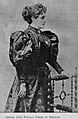
- Natalia Górriz de Morales: She was a very important teacher. She led the "Normal Central Institute for Girls." She also worked as an inspector for elementary schools. Natalia Górriz de Morales became one of the most well-known women in Guatemala in the early 1900s.
Climate in Chimaltenango
Chimaltenango has a subtropical highland climate. This means it has mild temperatures and a good amount of rain.
| Climate data for Chimaltenango | |||||||||||||
|---|---|---|---|---|---|---|---|---|---|---|---|---|---|
| Month | Jan | Feb | Mar | Apr | May | Jun | Jul | Aug | Sep | Oct | Nov | Dec | Year |
| Mean daily maximum °C (°F) | 22.0 (71.6) |
22.9 (73.2) |
24.7 (76.5) |
25.1 (77.2) |
24.9 (76.8) |
23.1 (73.6) |
23.3 (73.9) |
23.7 (74.7) |
23.0 (73.4) |
22.2 (72.0) |
22.3 (72.1) |
22.1 (71.8) |
23.3 (73.9) |
| Daily mean °C (°F) | 15.6 (60.1) |
16.3 (61.3) |
17.7 (63.9) |
18.8 (65.8) |
19.1 (66.4) |
18.5 (65.3) |
18.3 (64.9) |
18.4 (65.1) |
18.1 (64.6) |
17.4 (63.3) |
16.7 (62.1) |
15.9 (60.6) |
17.6 (63.6) |
| Mean daily minimum °C (°F) | 9.3 (48.7) |
9.7 (49.5) |
10.7 (51.3) |
12.6 (54.7) |
13.4 (56.1) |
14.0 (57.2) |
13.4 (56.1) |
13.1 (55.6) |
13.3 (55.9) |
12.6 (54.7) |
11.2 (52.2) |
9.7 (49.5) |
11.9 (53.5) |
| Average precipitation mm (inches) | 3 (0.1) |
4 (0.2) |
4 (0.2) |
37 (1.5) |
106 (4.2) |
259 (10.2) |
186 (7.3) |
178 (7.0) |
242 (9.5) |
125 (4.9) |
32 (1.3) |
7 (0.3) |
1,183 (46.7) |
| Source: Climate-Data.org | |||||||||||||
Where Chimaltenango is Located
Chimaltenango is surrounded by other towns in the Chimaltenango Department.
 |
San Martín Jilotepeque | |
||
| Zaragoza | El Tejar | |||
| San Andrés Itzapa | Parramos |
Images for kids
-
Teacher Natalia Górriz de Morales

See also
 In Spanish: Chimaltenango (municipio) para niños
