Chincha Province facts for kids
Quick facts for kids
Chincha
|
|||
|---|---|---|---|
|
|||

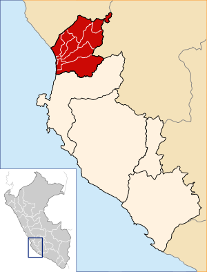
Location of Chincha in the Ica Region
|
|||
| Country | Peru | ||
| Region | Ica | ||
| Capital | Chincha Alta | ||
| Area | |||
| • Total | 2,988.27 km2 (1,153.78 sq mi) | ||
| Population
(2005 census)
|
|||
| • Total | 181,777 | ||
| • Density | 60.83018/km2 (157.5494/sq mi) | ||
| UBIGEO | 1102 | ||
The Chincha Province is one of five provinces in the Ica Region of Peru. Its capital city is Chincha Alta. This area was an important center where the culture of Black Peruvians developed. Chincha is known for its many schools and its textile fabrics.
Contents
Geography of Chincha
Chincha Province is located in a special part of Peru. It has different neighbors around it.
Where is Chincha located?
- North: It shares a border with the Lima Region.
- East: It is next to the Huancavelica Region.
- South: It borders the Pisco Province.
- West: It touches the Pacific Ocean, which is a very large body of water.
How Chincha is Governed
The Chincha Province is divided into eleven smaller areas called districts. Each district has its own mayor, known as an alcalde in Spanish.
Districts of Chincha
Here are the eleven districts that make up Chincha Province:
- Alto Larán
- Chavín
- Chincha Alta
- Chincha Baja
- El Carmen
- Grocio Prado
- Pueblo Nuevo
- San Juan de Yanac
- San Pedro de Huacarpana
- Sunampe
- Tambo de Mora
See Also
- For more information in Spanish, check out: Provincia de Chincha para niños
- Learn more about how Peru is divided: Administrative divisions of Peru
Black History Month on Kiddle
Famous African-American Labor Activists
 | Leon Lynch |
 | Milton P. Webster |
 | Ferdinand Smith |

All content from Kiddle encyclopedia articles (including the article images and facts) can be freely used under Attribution-ShareAlike license, unless stated otherwise. Cite this article:
Chincha Province Facts for Kids. Kiddle Encyclopedia.


