
Chippewas of Kettle and Stony Point First Nation facts for kids
Quick facts for kids
Kettle Point 44
Wiiwkwedong Anishinaabek
|
|
|---|---|
|
Ingidenous Reserve
|
|
| Kettle Point Indigenous Reserve No. 44 | |

Administration building
|
|

Kettle Point 44
Location in Southern Ontario
|
|
| Country | |
| Province | |
| County | Lambton |
| First Nation | Chippewas of Kettle and Stony Point |
| Settled | 1827 |
| Government | |
| • Type | First Nation Council Government |
| Area | |
| • Land | 9.20 km2 (3.55 sq mi) |
| Population
(2021)
|
|
| • Total | 1,233 |
| • Density | 132.3/km2 (343/sq mi) |
| Time zone | UTC-5 (EST) |
| • Summer (DST) | UTC-4 (EDT) |
| Postal Code |
N0N 1J1
|
| Area code(s) | 519 and 226 |
| Website | www.kettlepoint.org |
The Kettle & Stony Point First Nation is a community of Anishinaabeg people. Their traditional name is Ojibwe: Wiiwkwedong Anishinaabek, which means "in/at the bay." This First Nation includes two reserves: Kettle Point and Stony Point.
These reserves are located about 35 kilometers northeast of Sarnia, Ontario, Canada. They are on the southern shore of Lake Huron. The land here is the home base for the Chippewas (Anishnaabeg) of Kettle and Stony Point First Nation. They are one of 42 Anishinaabeg First Nations in Ontario. All these nations belong to the Anishinabek Nation Grand Council.
Contents
History of the Kettle & Stony Point First Nation
The Chippewa people are also known as Ojibwe in Canada. They are an Anishinaabe-speaking Indigenous nation. Their people live in both Canada and the United States today.
How the First Nation is Governed
The Kettle & Stony Point First Nation is led by a Chief and a Council. These leaders are chosen by the community. They work to make decisions for their people and manage the reserves.
Over the years, many Chiefs have led the First Nation. Some early Chiefs included Oshawnoo and Whapagas. Later, leaders like John Johnston and Isaac Shawnoo helped guide the community.
After separating from the "Sarnia Band Council," the First Nation began electing its own Chiefs. Cornelius Shawnoo was one of the first elected Chiefs in 1919. More recently, leaders like Thomas M. Bressette and Elizabeth Cloud have served. The current Chief is Kim Bressette.
The Present Elected Council Members for 2022-24 are:
- Elizabeth Cloud
- Carmen Rogers Jr.
- Al Wolfe
- Ronald C. George
- Jack Brown
- Marshall George
- Larry Vincent George
- Stan Cloud
- Melissa Monague
Important Land Issues
During World War II in 1942, the Canadian government needed land. They took over part of the Stony Point reserve to build a military camp called Camp Ipperwash. The government offered to pay the First Nation, but the offer was refused. The government had promised to return the land after the war. However, they continued to use it for many years. This caused problems and tension for the community.
In the 1990s, some First Nation members began to protest. They started to occupy parts of the military base in 1993. The military left the base completely in 1995. Later that year, some members also protested at a nearby park, Ipperwash Provincial Park. They said they were protecting an important burial ground. During a protest, an Ojibwe man named Dudley George died.
After this event, many people called for an investigation. An official inquiry, called the Ipperwash Inquiry, started in 2004. It looked into what happened and finished in 2007.
In 2009, the government officially returned the land to the First Nation. They now work together to manage the land. This includes dealing with environmental issues. In 2015, the First Nation received a $90 million payment. This was to settle the land claim related to Camp Ipperwash. The money was shared among the community members.
Today, investigations are still happening to check the environmental impact of the military base. This is important because the base was used as a firing range. Sometimes, old military items are found. The Government of Canada and the First Nation are working together on this cleanup.
Population and Community Information
In May 2008, about 1260 people lived in the Kettle & Stony Point First Nation. Around 900 members lived off the reserve at that time. By January 2011, there were 2219 registered members in total. About 1300 of them lived on their own reserve. By July 2012, the number of registered members grew to 2337. About 1316 of these members lived on the reserve.
| Canada census – Chippewas of Kettle and Stony Point First Nation community profile | |||
|---|---|---|---|
| 2011 | 2006 | ||
| Population: | 936 (-8.2% from 2006) | 1020 (24.1% from 2001) | |
| Land area: | 9.20 km2 (3.55 sq mi) | 9.20 km2 (3.55 sq mi) | |
| Population density: | 101.7/km2 (263/sq mi) | 110.8/km2 (287/sq mi) | |
| Median age: | 32.1 (M: 29.1, F: 35.6) | 35.2 (M: 33.8, F: 36.4) | |
| Total private dwellings: | 775 | 774 | |
| Median household income: | $34,688 | ||
| References: 2011 2006 earlier | |||
Geology of Kettle Point
Kettle Point is famous for a special type of rock. It's an outcrop of an Upper Devonian shale. This rock layer is called the Kettle Point Formation. You can see it at the tip of the point near Lake Huron.
Sometimes, round or oval-shaped rocks are found here. Locals call them "kettles." These "kettles" break out of the shale along the shoreline. For the local Anishinabek people, these unique stones were seen as thunderbird eggs. These concretions are now protected.
Just offshore, there's another rock layer. It's part of the Hamilton Group of shales and limestones. This layer contains a lot of light-colored, high-quality chert. Chert is a very useful stone. Ancient people used it to make tools like arrowheads and scrapers.
About ten thousand years ago, during a time when lake levels were lower, this chert was easy to find. Evidence of this has been found nearby. Kettle Point chert was used far and wide for tools.
Images for kids
-
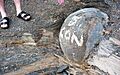
"Kettle" concretion at Kettle Point, Ontario, defaced by graffiti.

