Chuy facts for kids
Quick facts for kids
Chuy
|
|
|---|---|
|
City
|
|
 |
|
| Country | |
| Department | |
| Elevation | 13 m (43 ft) |
| Population
(2011 Census)
|
|
| • Total | 9,675 |
| Time zone | UTC −3 |
| Postal code |
27100
|
| Dial plan | +598 4474 (+4 digits) |
| Climate | Cfa |
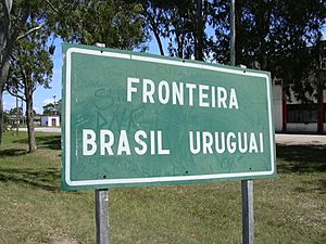
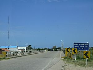
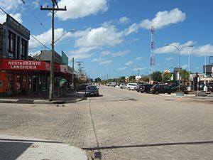
Chuy is a special city in the eastern part of Uruguay. It's located in the Rocha Department, about 340 kilometers (211 miles) northeast of Montevideo, the capital city. What makes Chuy unique is that it sits right on the border with Brazil. It's separated from its Brazilian sister city, Chuí, by just one shared street and a small stream called the Arroyo Chuy. In 2011, Chuy had a population of 9,675 people.
Contents
What Does "Chuy" Mean?
The name "Chuy" likely comes from the Tupi–Guarani language, spoken by native people. Many experts believe it was the name given to the small stream where the city grew up.
Some scholars, like Daniel Granada, say "Chuy" was also the name for a yellow-breasted bird common in the local marshes. Another idea from Tancredo Blotta suggests "Chuy" means "river of brown water."
A Brazilian historian, Péricles Azambuja, mentioned a rumor that the word (originally Chyu) came from tribes who moved from the Andes mountains. In the Quechua language, achuy meant "teaching" through stories, so chuy'o could mean "master" or "storyteller."
In other situations, chuy can refer to a small frog, toad, turtle, or even a small horse. These ideas often come from the fact that the Chuy stream is quite small compared to other waterways nearby.
A Look Back at Chuy's History
In the late 1600s, Portugal and Spain started to settle the area known as the Banda Oriental. They built important places like Colonia del Sacramento in 1680 and Montevideo in 1726. Later, they built forts like Fuerte de San Miguel in 1737 and Fortaleza de Santa Teresa in 1762.
The Treaty of Madrid (1750) tried to set clear borders. In 1751, military outposts were set up on both sides of the Chuy stream to guard the border. However, these agreements often changed as Spain and Portugal continued to argue over the land.
In 1762, after some battles, the Spanish leader Pedro de Cevallos took control of Portuguese areas, including Chuy. The situation remained uncertain for many years. A new agreement, the First Treaty of San Ildefonso in 1777, aimed to draw clearer lines for their territories in South America.
Scientists from both Spain and Portugal came to the Chuy area in 1784 to help mark the border. Over time, Spain's power in these lands began to fade.
By 1826, there was likely a farmhouse in Chuy. An old map from 1861 shows a ranch, stables, and a general store. There was even a chemist and a teacher giving private lessons. Because this border area became more important, a police station was set up in 1872.
In 1888, Chuy was officially recognized as a town. Uruguay and Brazil continued to work out their border differences through treaties and by placing boundary markers in the 20th century.
Chuy grew steadily:
- On January 14, 1938, it became a "Pueblo" (village).
- On June 29, 1961, it was made a "Villa" (town).
- Finally, on December 11, 1981, Chuy was officially named a "Ciudad" (city).
Chuy's Location and Unique Border
Chuy is located on National Route 9 in Uruguay. It's very close to Brazil's Route BR 471. The city is only about 15 kilometers (9 miles) from the Atlantic Ocean. It's also a similar distance from the Lagoa Mirim, a large lake, to its north.
The main street in Chuy is quite special. It's a two-lane road that serves as the border itself! On the Brazilian side, it's called Avenida Uruguai ("Uruguay Avenue"). As you cross into Uruguay, its name changes to Avenida Brasil ("Brazil Avenue").
Both countries have their immigration offices at the entrance to the city. On the Brazilian side, you'll find shops selling clothes, shoes, and household items. On the Uruguayan side, Chuy is famous for its duty-free shops and a casino.
Who Lives in Chuy?
Most people living in Chuy are from Uruguay or Brazil. Almost everyone speaks both Spanish and a local version of Uruguayan Portuguese. The city councils of Chuy and Chuí often work together to organize fun cultural events. One popular event is the "Carnival Chuy-Chuí Without Borders."
There's also a small but important community of Palestinian Uruguayans in Chuy, many of whom are Muslims.
Population Growth
Here's how Chuy's population has changed over the years:
| Year | Population |
|---|---|
| 1963 | 2,876 |
| 1975 | 4,521 |
| 1985 | 8,257 |
| 1996 | 9,804 |
| 2004 | 10,401 |
| 2011 | 9,675 |
Source: Instituto Nacional de Estadística de Uruguay
Chuy's Economy and Shopping
Chuy is a busy city for trade, especially with Brazilians. It has many shops that attract tourists and shoppers. It's common for Uruguayans from places like Montevideo to travel long distances to buy goods in Chuy. These items can be much cheaper there because of the duty-free shops.
Many duty-free shops offer things like perfumes, cosmetics, clothes, and luxury items. A fun fact is that there's a casino in Uruguay's Chuy, but gambling is not allowed on the Brazilian side of the border.
Cool Places to See in Chuy
Chuy has several hotels like Hotel Internacional, Chuy, Hotel Alerces, and Nuevo Hotel Plaza. There are also hostels and apartments. If you like sports, the Estadio Samuel Prillac is in the southeastern part of town. The city also has the Chuy Hospital.
About 10 kilometers (6 miles) away, near the Barro du Chui inlet, there's a lighthouse. The beaches in this area are usually not too crowded, and you might even spot sea lions!
Fuerte San Miguel
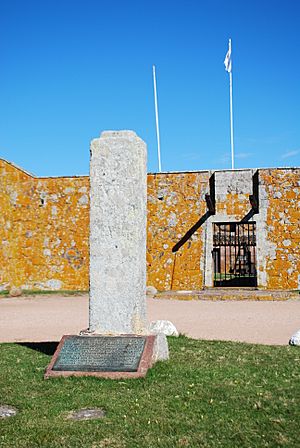
The Fuerte San Miguel is an old fort located about 8 kilometers (5 miles) west of Chuy. It was started in 1734 and built by the Portuguese on top of a hill in 1737. The fort has a square shape with four tall towers (bastions), thick walls, and strong ramparts. It was built with large, heavy stones to help it survive many battles against Spanish invaders. This fort played an important role in Uruguay becoming an independent country.
The fort is made of pink granite stones and has a moat (a ditch filled with water) around it. It has been fully restored and is located in the town of Dieciocho de Julio, a short drive from Chuy.
After Uruguay gained independence, the fort started to fall apart. But in 1927, an archaeologist named Horacio Arredondo helped restore it. Today, the fort looks much like it did in the past, with its old moat and a drawbridge. It's surrounded by a beautiful garden. The area around the fort is protected, so you can still see native wildlife like monkeys, birds, capybaras, and guazubira deer in the forests and marshland.
The Uruguayan Army manages the fort, and it's always open to visitors. Inside, there's a Museum of Military History where you can see old uniforms and learn about the history of the Army.
Fortaleza de Santa Teresa
The Fortaleza de Santa Teresa is another historic fort that was declared a National Historic Monument in 1927. It's about 36 kilometers (22 miles) south of Chuy, inside the Parque Nacional de Santa Teresa.
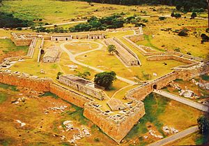
This fort has a rich history of battles. The Portuguese started building it in October 1762, expecting war with Spain. However, the Spanish captured it in 1763 and continued its construction. The fort has an irregular five-sided shape with five bastions and a perimeter of 942 meters (3,091 feet).
Over the years, the fort changed hands many times between the Portuguese, Spanish, and Uruguayan Patriots. After Uruguay became independent in 1828, the fort's importance decreased, and it was eventually abandoned.
Today, the fort is part of the San Miguel National Park, which covers 3,000 hectares (7,400 acres). The fort has been restored and is a major attraction for visitors to the park. The park also offers beautiful beaches and forested areas. The Uruguayan Army is in charge of managing and maintaining Santa Teresa. It's located about 800 meters (2,600 feet) from the coast at Playa la Moza.
Places to Worship
- Parish Church of the Assumption of the Most Holy Virgin Mary (Roman Catholic)
See also
 In Spanish: Chuy para niños
 | Jessica Watkins |
 | Robert Henry Lawrence Jr. |
 | Mae Jemison |
 | Sian Proctor |
 | Guion Bluford |


