Cimarron Hills, Colorado facts for kids
Quick facts for kids
Cimarron Hills, Colorado
|
|
|---|---|

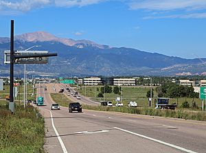
Looking west along East Platte Avenue in Cimarron Hills.
|
|

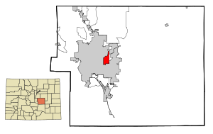
Location of the Cimarron Hills CDP in El Paso County, Colorado.
|
|
| Country | |
| State | |
| County | El Paso County |
| Government | |
| • Type | unincorporated community |
| Area | |
| • Total | 5.942 sq mi (15.391 km2) |
| • Land | 5.939 sq mi (15.382 km2) |
| • Water | 0.003 sq mi (0.009 km2) |
| Elevation | 6,463 ft (1,970 m) |
| Population
(2020)
|
|
| • Total | 19,311 |
| • Density | 3,249.64/sq mi (1,254.69/km2) |
| Time zone | UTC-7 (MST) |
| • Summer (DST) | UTC-6 (MDT) |
| ZIP Code |
Colorado Springs 80914, 80915, and 80922
|
| Area code(s) | 719 |
| GNIS feature | Cimarron Hills CDP |
Cimarron Hills is a community in El Paso County, Colorado, United States. It is known as a "census-designated place" (CDP). This means it's an area the government tracks for population data, even though it's not officially a city or town.
Cimarron Hills is like a small area surrounded by the larger City of Colorado Springs. It's also part of the bigger Colorado Springs metropolitan area. In 2020, about 19,311 people lived here. The Colorado Springs post office handles mail for Cimarron Hills, using ZIP Codes 80914, 80915, and 80922.
Contents
Where is Cimarron Hills Located?
Cimarron Hills is in El Paso County, Colorado. It covers an area of about 15.4 square kilometers (about 5.9 square miles). A very small part of this area, about 0.009 square kilometers (0.003 square miles), is water.
How Many People Live in Cimarron Hills?
The United States Census Bureau first started counting Cimarron Hills as a CDP in 1980. Since then, its population has grown quite a bit.
| Cimarron Hills CDP, Colorado | ||
|---|---|---|
| Year | Pop. | ±% |
| 1980 | 6,597 | — |
| 1990 | 11,160 | +69.2% |
| 2000 | 15,194 | +36.1% |
| 2010 | 16,161 | +6.4% |
| 2020 | 19,311 | +19.5% |
| Source: United States Census Bureau | ||
Getting Around Cimarron Hills
Roads and Highways
Cimarron Hills is easy to reach by car. It is only about 1.5 miles north of U.S. Highway 24. This is a major road that can take you to many places. The community is also about 9 miles from Interstate 25, which is a big highway that runs north and south through Colorado.
Air Travel
If you need to fly, the Colorado Springs Airport is very close. It is located just three miles south of Cimarron Hills.
Railroad History
Long ago, Cimarron Hills was part of a railroad route.
- In 1888, the Chicago, Rock Island and Pacific Railroad built a main line through Cimarron Hills. This line connected Limon to Colorado Springs.
- From 1939 to 1966, a passenger train called the Rocky Mountain Rocket used this line.
- Later, the Cadillac and Lake City Railroad provided service between Cimarron Hills and Limon.
- Even though the tracks were removed in the 1980s, you can still see where the railroad used to be. If you look at aerial maps, you can spot a U-shape that shows the old railroad path.
See also
 In Spanish: Cimarron Hills para niños
 | Emma Amos |
 | Edward Mitchell Bannister |
 | Larry D. Alexander |
 | Ernie Barnes |


