Clark Reservation State Park facts for kids
Quick facts for kids Clark Reservation State Park |
|
|---|---|

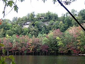
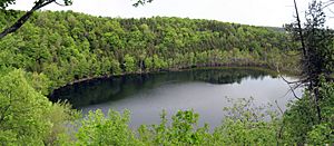
Glacier Lake and the cliff of the fossil waterfall in September
|
|
| Lua error in Module:Location_map at line 420: attempt to index field 'wikibase' (a nil value). | |
| Location | Onondaga County, New York, USA |
| Nearest city | Syracuse, New York |
| Created | 1928 |
| Visitors | 81,771 (in 2016) |
| Website | https://parks.ny.gov/parks/126/details.aspx |
Clark Reservation State Park is a special state park in Onondaga County, New York. It's located in Jamesville, south of Syracuse. This park was once the site of a huge waterfall! It formed from melting ice at the end of the last Ice Age. The deep pool at the bottom of that old waterfall is now a small lake called Glacier Lake.
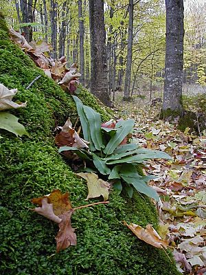
In 1879, someone described the park as a "yawning gulf, precisely like that of the Niagara River below the Falls, and nearly as deep." Clark Reservation is also famous for its many ferns. It has the largest group in the U.S. of a very rare fern called American hart's tongue. This fern is so rare that it was declared endangered in the U.S. in 1989.
The park covers about 377 acres (153 hectares). Around 80,000 people visit it each year. It includes the cliff, the deep basin, and a gorge from the ancient waterfall. There are also smaller ravines and basins. Glacier Lake is 6.2 acres (2.5 hectares) big and 52 feet (16 meters) deep. It's a rare meromictic lake, which means its deep waters don't mix with the surface waters every year. The limestone cliffs around the lake are 180 feet (55 meters) high. You can hike trails along the cliffs and over the rugged limestone where the old river once flowed.
The Friends of Clark Reservation, a group of volunteers, run a Nature Center. It has exhibits about the park's geology and nature. The center is open from Memorial Day to Labor Day. This group also plans events and hires a naturalist in the summer. The naturalist leads hikes and creates nature programs for visitors. The park also offers fishing, hiking trails, picnic areas, and a playground.
Park History: How Clark Reservation Was Saved
Before Europeans arrived, the land around the park belonged to the Onondaga tribe. In the late 1700s, these lands were divided up. They were given to soldiers returning from the Revolutionary War.
In 1879, James Macfarlane bought the area around the fossil waterfall and the lake. He opened a small resort hotel there. Macfarlane was a lawyer and a geologist. He loved the area, which was then called Green Lake. (It was later renamed Glacier Lake to avoid confusion with another nearby Green Lake.) The resort offered picnics, boating, fishing, and games. But it closed after only a few years.
The main part of the park today, about 75 acres (30 hectares), was bought by Mary Clark Thompson in 1915. She learned that the fossil waterfall area might be used for a limestone quarry. Huge limestone quarries were already nearby. Thompson gave this land to the New York State Museum. She wanted it to be a memorial to her father, Myron H. Clark. He had been governor of New York State from 1855-56. Clark Reservation officially became a state park in 1926.
In 2010, there was a plan to close Clark Reservation State Park to save money. But new laws were passed, and the park stayed open for visitors.
Amazing Ferns of Clark Reservation
Clark Reservation is famous for its many different kinds of ferns. A survey in 1994 found 26 different fern species! The park is now the most important place in the United States for protecting the American hart's tongue fern. This fern is very rare in North America. It was first found on the continent in 1807 by a botanist named Frederick Traugott Pursh. He found it at a place called Split Rock, also in Onondaga County.
In the late 1800s, people became very interested in ferns. This time was even called "pteridomania" (which means "fern madness"). Finding new places where hart's tongue ferns grew was very exciting back then. The ferns near Glacier Lake were first reported in 1866. Today, several spots within Clark Reservation have these ferns. Because they are so rare, people have been counting them in this part of New York since 1916. In 1989, this fern was declared an endangered species in the United States.
Another lake about 2 miles (3 km) east of Glacier Lake used to have the most hart's tongue ferns until about 1925. This lake was also threatened by limestone quarrying. Just before it was destroyed, about 1,000 hart's tongue ferns were moved from there to Clark Reservation. Some people believe that Clark Reservation became a state park in 1926 because people wanted to save the American hart's tongue fern. In 1930, a state law was passed to protect the hart's tongue fern in Onondaga and Madison County.
Geology: The Story of the Ancient Waterfall

The amazing fossil waterfall and many other features at Clark Reservation were created about 10,000 years ago. This was near the end of the last ice age, called the Wisconsin glaciation. At that time, huge sheets of ice covered much of New York. As the ice melted, it formed large lakes.
The melting ice blocked the northern ends of these lakes. So, massive amounts of glacial meltwater (water from melting ice) had to find a way to flow south. These powerful rivers carved deep channels into the rock. These channels are now called "the Syracuse channels."
As the ice sheet slowly melted and moved north, it created a series of lower and lower channels. One early channel was Smoky Hollow, about a mile south of Clark Reservation. Later, as the ice retreated further, the water found a new, lower path through what is now Clark Reservation. A giant waterfall formed here, and the deep pool at its base eventually became Glacier Lake. As the ice moved even further north, it carved out even lower channels.
The fossil waterfall at Clark Reservation was about 180 feet (55 meters) high. This is even a bit taller than Niagara Falls (which is 174 feet or 53 meters high)! Just like at Niagara Falls, the waterfall here was so well-defined because of a hard layer of limestone rock. This limestone was strong and didn't wear away easily from the flowing water.
The limestone rock at Clark Reservation is deeply worn and cracked by water. This shows how powerful the ancient river was. The limestone area leading to the cliff is an example of "karst" topography. This means the landscape was shaped by water dissolving the limestone rock. One cool feature is a deep dip in the limestone called Dry Lake. Dry Lake is about 12 meters (39 feet) deep and covers 2 hectares (5 acres). It's a unique place for plants to grow. Scientists believe it's a sinkhole that formed when water dissolved the limestone bedrock.
 | Delilah Pierce |
 | Gordon Parks |
 | Augusta Savage |
 | Charles Ethan Porter |


