Clarks Grove, Minnesota facts for kids
Quick facts for kids
Clarks Grove
|
|
|---|---|

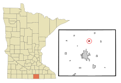
Location of Clarks Grove, Minnesota
|
|
| Country | United States |
| State | Minnesota |
| County | Freeborn |
| Area | |
| • Total | 0.64 sq mi (1.65 km2) |
| • Land | 0.60 sq mi (1.55 km2) |
| • Water | 0.04 sq mi (0.10 km2) |
| Elevation | 1,303 ft (397 m) |
| Population
(2020)
|
|
| • Total | 694 |
| • Density | 1,158.60/sq mi (447.41/km2) |
| Time zone | UTC-6 (Central (CST)) |
| • Summer (DST) | UTC-5 (CDT) |
| ZIP code |
56016
|
| Area code(s) | 507 |
| FIPS code | 27-11674 |
| GNIS feature ID | 2393539 |
Clarks Grove is a small city in Freeborn County, Minnesota, United States. It is located in the southern part of Minnesota. In 2020, about 694 people lived in Clarks Grove.
Contents
The Story of Clarks Grove
How Clarks Grove Started
Clarks Grove began in 1890. This was about ten years before the railroad reached the area. It officially became a village on February 27, 1920. A train station for the Chicago and Northwestern Railway was also here. The city's post office opened even earlier, in 1857. Mr. Clark was the first postmaster.
A Special Creamery
In 1890, something important happened. Farmers from Denmark started the Clarks Grove Cooperative Creamery. This creamery was very successful. It was one of the first cooperative creameries in Minnesota.
A Stormy Day
In March 2017, a tornado hit the community. Some buildings in Clarks Grove were damaged.
Where is Clarks Grove?
Location and Size
Clarks Grove is a small city. It covers a total area of about 0.59 square miles (1.53 square kilometers). Most of this area is land, about 0.55 square miles (1.42 square kilometers). A small part, about 0.04 square miles (0.10 square kilometers), is water.
Roads and Highways
The city is easy to reach. It is located along Interstate 35. This is a major highway. Other important roads include State Highway 251 (MN 251). County Roads 31 and 45 also pass through Clarks Grove.
People of Clarks Grove
How Many People Live Here?
The number of people living in Clarks Grove has changed over the years. Here is a quick look at the population from different years:
| Historical population | |||
|---|---|---|---|
| Census | Pop. | %± | |
| 1930 | 180 | — | |
| 1940 | 203 | 12.8% | |
| 1950 | 254 | 25.1% | |
| 1960 | 353 | 39.0% | |
| 1970 | 480 | 36.0% | |
| 1980 | 620 | 29.2% | |
| 1990 | 675 | 8.9% | |
| 2000 | 734 | 8.7% | |
| 2010 | 706 | −3.8% | |
| 2020 | 694 | −1.7% | |
| U.S. Decennial Census | |||
A Look at the 2010 Census
In 2010, there were 706 people living in Clarks Grove. These people lived in 295 households. About 197 of these were family households. The city had about 1284 people per square mile. There were 312 housing units in total.
Most of the people in Clarks Grove were White (93.9%). A small number were African American (0.6%), Native American (0.4%), or Asian (0.4%). Some people were from other races (2.4%) or from two or more races (2.3%). About 6.8% of the population was Hispanic or Latino.
Households and Families
About 31.2% of households had children under 18. Many households (50.8%) were married couples. Some households had a female head (8.5%) or a male head (7.5%) without a spouse. About 33.2% of households were not families.
Almost 28.5% of all households were individuals living alone. About 8.8% of these were people aged 65 or older. The average household had 2.39 people. The average family had 2.90 people.
Age in Clarks Grove
The average age of people in the city was 38.1 years. About 25.4% of residents were under 18 years old. About 8.4% were between 18 and 24. People aged 25 to 44 made up 24.4% of the population. Those aged 45 to 64 were 27.6%. Finally, 14.3% of residents were 65 years or older. The city had slightly more males (50.6%) than females (49.4%).
See also
 In Spanish: Clarks Grove (Minnesota) para niños
 | James Van Der Zee |
 | Alma Thomas |
 | Ellis Wilson |
 | Margaret Taylor-Burroughs |

