
Clatchard Craig facts for kids

An aerial photograph of Clatchard Craig taken in 1932. (Royal Air Force)
|
|
| Location | Newburgh |
|---|---|
| Region | Fife |
| Coordinates | Lua error in Module:Coordinates at line 614: attempt to index field 'wikibase' (a nil value). |
| Type | Pictish hill fort |
| History | |
| Builder | Picts |
| Material | Timber faced earth and stone |
| Periods | Neolithic Bronze age Iron age Roman Pictish |
| Site notes | |
| Excavation dates | 1954–55 1959–60 |
| Condition | Destroyed by quarrying |
Clatchard Craig was an important Pictish hill fort located on a hill near the River Tay in Scotland. People lived or visited this spot for a very long time, starting from the Stone Age. The fort itself was used from the 500s AD until at least the 700s AD.
It was close to other important places of power, like Abernethy and Scone. This suggests that Clatchard Craig was a significant stronghold for the Picts. Sadly, in the late 1900s, the entire fort was destroyed by quarrying. This was done to get materials for building roads. Today, the site is still a quarry and is privately owned.
Contents
Where Was Clatchard Craig?
Clatchard Craig fort sat on a hill that was 119 meters (about 390 feet) high. From the hill, you could see the flat land near the River Tay. Today, the town of Newburgh is located between the old fort site and the river.
The fort was on the west side of a valley entrance that led south into central Fife. On the east side of this valley was another peak called 'Mare's Craig'. Some old artifacts were found there, but it was never properly dug up. 'Mare's Craig' was also destroyed by quarrying in the 1900s. A smaller, single-walled fort called 'Black Cairn Hill' is still mostly intact to the southwest of where Clatchard Craig used to be.
What We Knew Before Digging
The name Clatchard Craig comes from the Gaelic words 'clach', 'ard', and 'creag'. These mean 'stone', 'high', and 'crag'. This makes sense because the hill once had a tall, freestanding stone pillar. This pillar was 27 meters (about 89 feet) high. It was taken down in 1846 when the Edinburgh and Northern Railway was being built.
The first mention of the site was in the early 1600s by James Balfour. He wrote about a "strange castell" on a "great rock" near his home. He believed it was destroyed by Roman forces, but he didn't say why. Later, in 1711, Robert Sibbald also mentioned Clatchard. He too thought the Romans built it. Clatchard Craig was actually quite close to a real Roman site, Carpow Roman Fort, which was a large fortress built by the Romans.

Quarrying started in the area when the railway arrived. The hill had valuable rock called andesite, which was great for building roads and railways. So, the quarrying continued. As the quarry got closer to the fort, the British Ministry of Works stepped in. They carried out two "rescue excavations" in 1954–55 and 1959–60. These digs were meant to study the site before it was completely destroyed. The Ministry of Works had tried to stop the quarrying earlier, between the two World Wars. However, the Ministry of Transport overruled them, and the quarrying went on.
Discoveries from the Digs

The two excavations at Clatchard Craig, along with other finds, help us understand its long history. The earliest signs of people living there were pottery pieces and a stone ball. These date back to the Stone Age. People continued to live there during the Bronze Age. This was shown by finding a stone burial box and pottery from the beaker culture.
During the Iron Age, more pottery was found in both the upper and lower parts of the site. The site was also used during the Roman era. Archaeologists found a rotary quern (a type of hand mill), Iron Age pottery, and pieces of fancy Roman pottery called Samian ware. However, not many of these items were from the 2nd and 3rd centuries AD. This was when Rome was very active in central Scotland. During these centuries, the Antonine Wall was in use, and the Roman emperor Septimius Severus led a military campaign in the area. The nearby Roman fortress of Carpow was built around this time.

The first signs of permanent buildings at Clatchard Craig are from the Dark Ages. When it was a fortress, it had six ramparts (protective walls) around a building at the top of the hill. The fort was built in three main stages. The latest part was a rectangular area on top, about 70 meters (230 feet) long and 35 meters (115 feet) wide. Here, they found items from the early medieval period. This area was inside a larger oval rampart, about 100 meters (330 feet) long and 60 meters (200 feet) wide.
The next rampart was built over old fireplaces where pottery was found. This rampart also contained stone blocks with mortar and pieces of Roman tiles. The third rampart, like the first two, was made of timber and stone. Later, it was replaced with earth and stone. There were two more ramparts with smaller additions. The two earliest ramparts, made of timber-laced stone, were built in the 500s AD. This was confirmed by radiocarbon dating. The building of the ramparts continued over time. They even reused Roman tiles and stones with mortar in the walls. At some point, the fort's walls became vitrified, meaning they were melted by intense heat. This suggests the fort was once destroyed by fire. We don't know exactly when this fire happened or when the fort was finally left empty.
Finding a paved fireplace at the top of the fort suggests that someone important lived there. The discovery of clay molds for making pennanular brooches (a type of pin) shows that skilled craftspeople worked inside the fort. An ingot of silver and evidence of fine metalworking also suggest that Clatchard Craig was a very important and high-status place.
Images for kids
-
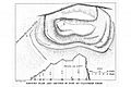
A plan of the fort made during the excavations of the twentieth century

