
Clavering Island facts for kids
|
Native name:
Clavering Ø
Nickname: Eskimonæs
|
|
|---|---|
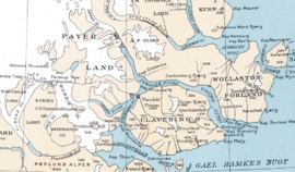
Map drawn during Lauge Koch's expedition 1931-1934
|
|

Clavering Island
Location in Greenland
|
|
| Etymology | Named to commemorate Douglas Charles Clavering |
| Geography | |
| Location | Greenland Sea |
| Coordinates | 74°16′N 21°00′W / 74.267°N 21.000°W |
| Area | 1,488 km2 (575 sq mi) |
| Area rank | 8th largest in Greenland |
| Highest elevation | 1,650 m (5,410 ft) |
| Highest point | Ortlerspids |
| Administration | |
| Unincorporated area | NE Greenland National Park |
| Demographics | |
| Population | 0 (2021) |
| Pop. density | 0 /km2 (0 /sq mi) |
| Ethnic groups | none |
Clavering Island (called Clavering Ø in Danish) is a large island in eastern Greenland. It is located off Gael Hamke Bay, south of Wollaston Foreland.
This island was once home to the Eskimonaes (Eskimonæs) radio and weather station. Danish scientists worked there. During World War II, German troops took over the station in 1943. The same spot was also where the last Inuit people lived in Northeast Greenland around 1823.
History
Clavering Island got its name from the second German North Polar Expedition in 1869–70. It was named Clavering Insel to remember Douglas Charles Clavering (1794–1827). He was the commander of the ship Griper during a trip in 1823. His crew explored the area. On the southern shore of this island, they had the first (and last) meeting between Europeans and the Northeast-Greenland Inuit. These Inuit are now extinct.
In August 1823, Clavering and his crew met a group of twelve Inuit. This group included men, women, and children. In his journal, Clavering wrote about their seal-skin tent, canoe, and clothes. He also described their harpoons and spears. These tools had tips made of bone and meteoric iron. He noted their "tawny coppery" skin, "black hair and round visages." Their hands and feet were "very fleshy, and much swelled." He was impressed by their skill in skinning a seal. He also mentioned their custom of sprinkling water over a seal or walrus before skinning. They were amazed when Clavering showed them how firearms worked for hunting.
Before 1823, European visitors to Northeast Greenland found signs of many Inuit settlements. However, they did not meet any people. Later expeditions, starting with the Second German North Polar Expedition in 1869, found the remains of many old settlements. It seems the Inuit population had died out in the years between these visits.
Bones of muskoxen have been found at Inuit sites on the island. But Clavering did not report seeing any live muskoxen in 1823. Many Arctic hare bones suggest the Inuit had to hunt smaller animals. This happened after the muskoxen disappeared from the area. After the Inuit died out, muskoxen returned. The first live muskoxen ever brought to Europe were captured on Clavering Island in 1899.
The Eskimonaes Station
The Eskimonaes radio and telegraph station was on a small peninsula on the south coast of Clavering Island. The place was named Eskimonæsset by the 1929-30 Expedition to East Greenland. This expedition was led by Lauge Koch. The name came from an abandoned Inuit settlement with four houses. Two of these houses were dug up at that time.
The station was built for scientific research. It was also used as a base by the Three-year Expedition to East Greenland. Other scientists used it from 1931 to 1939. From 1941 to 1943, it became the main office for the Danish North-East Greenland Sledge Patrol.
During World War II, the US Coast Guard used the code name 'Bluie East Five' for the Eskimonæs Station. This same code name was later used for Myggbukta after Eskimonæs was destroyed. German soldiers burned the main building at Eskimonaes on March 25, 1943. The US Air Force bombed the site on May 14 of the same year.
The burnt station was replaced by the Dødemandsbugten Station, also called Ny Station. This new station was built nearby, further east, later in 1943. Dødemandsbugten was then replaced by Daneborg in 1944. The ruins of the two older stations are still there today. They serve as a clear reminder of the war-time events. The story of the North-East Greenland Sledge Patrol's efforts in World War II was told by English author David Armine Howarth. He wrote about it in his 1951 book The Sledge Patrol.
Geography
Clavering Island is a coastal island. It is separated from the mainland by fjords and sounds of the Greenland Sea. Some of these waterways are quite narrow. The Tyrolerfjord forms the northern border of the island. Its extension, the Young Sound, is in the northeast. Rudi Bay and the Copeland Fjord are to the west. The Godthab Gulf is in the southwest, and Gael Hamke Bay is in the southeast. Payer Land is to the west, A. P. Olsen Land to the north, and Wollaston Foreland to the east and northeast.
The island's highest point is Ortlerspids, which is 1650 meters high. Clavering Island covers an area of 1534.6 square kilometers. Its shoreline is 165.4 kilometers long. The Halle Range (Hallebjergene) is a mountain chain on the southwest part of Clavering Island. These mountains are up to 1,200 meters high. Lauge Koch named them during his 1929–30 expedition.
Some small islands are located nearby. These include the Finsch Islands to the south and Jackson Island far to the southeast, at the mouth of the bay.
Images for kids
-
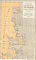
1870 map of the Northern Portion of Eastern Greenland showing coastal islands.
-
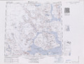
Map of the area around Clavering Island.

See also
 In Spanish: Isla Clavering para niños
- Greenland in World War II
- List of islands of Greenland
