Clear Fork (Guyandotte River tributary) facts for kids
Quick facts for kids Clear Fork |
|
|---|---|

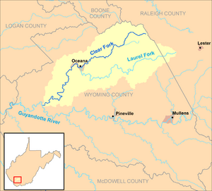
The Clear Fork and its watershed in Wyoming and Raleigh counties, West Virginia
|
|
| Country | United States |
| State | West Virginia |
| County | Wyoming |
| Physical characteristics | |
| Main source | Guyandotte Mountain, west of Bolt 2,701 ft (823 m) 37°45′47″N 81°26′46″W / 37.763168°N 81.4462161°W |
| River mouth | Guyandotte River southeast of Simon 1,102 ft (336 m) 37°36′27″N 81°43′50″W / 37.6076104°N 81.7306682°W |
| Length | 29 mi (47 km) |
| Basin features | |
| Basin size | 129 sq mi (330 km2) |
The Clear Fork is a river in southern West Virginia, United States. It is about 29 miles (47 km) long. This river is a "tributary," which means it's a smaller river that flows into a larger one. The Clear Fork flows into the Guyandotte River.
The Clear Fork is part of a bigger "watershed." A watershed is an area of land where all the water drains into a single river or lake. The Clear Fork's watershed covers about 129 square miles (334 square kilometers). All the water from this area eventually flows into the Ohio River and then into the mighty Mississippi River.
Where Does the Clear Fork Flow?
The Clear Fork starts in the northern part of Wyoming County, West Virginia. Its source is near Guyandotte Mountain, about 2 miles (3 km) west of a town called Bolt.
From there, the river generally flows towards the southwest. It travels through several small communities. These include Crany, Toney Fork, and Oceana.
Towns Along the River
As the Clear Fork continues its journey, it passes more towns. You'll find Lillyhaven, Lillydale, and a town actually named Clear Fork. The river also flows by Sun Hill.
The river stays entirely within Wyoming County. However, one of its smaller branches, called the Laurel Fork, also drains a small part of western Raleigh County.
Where the River Ends
The Clear Fork finally joins the Guyandotte River. This happens from the east, southeast of the community of Simon. This area is part of the R.D. Bailey Lake Wildlife Management Area.
You can often see the Clear Fork from nearby roads. West Virginia Route 85 runs alongside it between Toney Fork and Oceana. West Virginia Route 10 follows the river from Oceana north of Lillyhaven. And West Virginia Route 971 is close to the river between Lillyhaven and Clear Fork.
 | Precious Adams |
 | Lauren Anderson |
 | Janet Collins |

