Laurel Fork (Clear Fork Guyandotte River tributary) facts for kids
Quick facts for kids Laurel Fork |
|
|---|---|

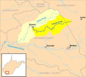
The Laurel Fork and its watershed, highlighted within the larger Clear Fork watershed, in Wyoming and Raleigh counties, West Virginia.
|
|
| Country | United States |
| State | West Virginia |
| Counties | Raleigh, Wyoming |
| Physical characteristics | |
| Main source | west of Lester 2,554 ft (778 m) 37°43′32″N 81°21′58″W / 37.725669°N 81.3662145°W |
| River mouth | Clear Fork Oceana 1,260 ft (380 m) 37°41′28″N 81°37′25″W / 37.6912220°N 81.6237207°W |
| Length | 23.5 mi (37.8 km) |
| Basin features | |
| Basin size | 56.4 sq mi (146 km2) |
The Laurel Fork is a small river, or a "tributary," in southern West Virginia, United States. It flows into another river called the Clear Fork. The Laurel Fork is about 23.5 miles (37.8 km) long.
This river is part of a bigger water system. Its water eventually flows into the Guyandotte, then the Ohio, and finally the mighty Mississippi River. The area it drains, called its "watershed," is about 56.4 square miles (146 km2). This area is mostly rural and sits on a part of the Allegheny Plateau that was never covered by glaciers.
Where the Laurel Fork Begins and Ends
The Laurel Fork starts in western Raleigh County. This is about 4 miles (6.4 km) west of a town called Lester.
Its Journey Through West Virginia
From its start, the river generally flows towards the west. It travels through the northern part of Wyoming County. Along its path, the Laurel Fork passes several small communities. These include Glen Rogers, Ravencliff, and Sabine. It also flows through Glen Fork, Jesse, Matheny, and Edith.
After passing through Jesse, a road called West Virginia Route 10 runs alongside the stream. The journey of the Laurel Fork ends in the town of Oceana. Here, it joins the Clear Fork from the east.
 | Selma Burke |
 | Pauline Powell Burns |
 | Frederick J. Brown |
 | Robert Blackburn |

