Clear Fork Brazos River facts for kids
Quick facts for kids Clear Fork Brazos River |
|
|---|---|

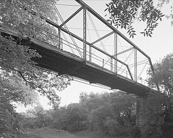
Fort Griffin Iron Truss Bridge spanning the Clear Fork
|
|
| Country | United States |
| State | Texas |
| Physical characteristics | |
| Main source | 2 miles (3.2 km) east-southeast of Hermleigh, Texas Scurry County, Texas 2,440 ft (740 m) 32°39′43″N 100°44′34″W / 32.66194°N 100.74278°W |
| River mouth | Confluence with Brazos River, 7.8 mi (12.6 km) south-southeast of Graham. Young County, Texas 1,017 ft (310 m) 33°00′57″N 098°40′08″W / 33.01583°N 98.66889°W |
| Length | 180 mi (290 km) |
| Basin features | |
| Basin size | 3,350 sq mi (8,700 km2) |
The Clear Fork Brazos River is an important waterway in Texas. It is the longest river that flows into the main Brazos River. This river begins in Scurry County as a channel that is often dry. It then travels a long way before joining the Brazos River.
Contents
Discovering the Clear Fork Brazos River
The Clear Fork Brazos River is a major part of the Brazos River system. It stretches for about 180 miles (290 km) across several counties in Texas. This river helps shape the landscape and supports local wildlife.
Where Does It Begin?
The Clear Fork Brazos River starts in Scurry County. Its source is about 2 miles (3.2 km) northeast of a town called Hermleigh. At its beginning, it's often just a dry channel or a small stream.
The River's Journey
As the river flows, it passes through many different areas. It travels through parts of Scurry, Fisher, Jones, Shackelford, and Throckmorton counties. Along its path, it collects water from smaller streams and rainfall.
Meeting Other Waters
Finally, after its long journey, the Clear Fork Brazos River meets the main Brazos River. This meeting point is in Young County. It's about 7.8 miles (12.6 km) south-southeast of the town of Graham.
One of the smaller streams that flows into the Clear Fork Brazos River is called Paint Creek. This creek is important because it has a dam that forms Lake Stamford. Lakes like Stamford are often used for recreation, like fishing and boating, and can also provide water for nearby communities.
 | Jackie Robinson |
 | Jack Johnson |
 | Althea Gibson |
 | Arthur Ashe |
 | Muhammad Ali |

