Clear Springs Wilderness facts for kids
Quick facts for kids Clear Springs Wilderness |
|
|---|---|
|
IUCN Category Ib (Wilderness Area)
|
|
 |
|
| Location | Jackson County, Illinois, USA |
| Nearest city | Wolf Lake, IL |
| Area | 4,730 acres (1,910 ha) |
| Established | 1990 |
| Governing body | U.S. Forest Service |
The Clear Springs Wilderness is a special natural area in Illinois, USA. It covers about 4,730 acres, which is like 3,500 football fields! This land is protected as a Wilderness Area of the United States. It includes the LaRue-Pine Hills Ecological Area, which is a National Natural Landmark. This area is famous for its many different kinds of snakes.
The wilderness is located within the Shawnee National Forest. You can find it in southwestern Jackson County and northwestern Union County in Illinois. The closest town is Wolf Lake, Illinois.
Contents
A Special Place for Nature
The Clear Springs Wilderness has steep hills and many limestone springs. These springs are natural places where water flows out of the ground. One of these is Clear Springs, which flows into Hutchins Creek and then into Clear Creek.
How the Wilderness Was Formed
Like other wilderness areas in Shawnee National Forest, Clear Springs Wilderness is made of second-growth forests. This means the trees growing there now are not the original ones. Until the 1930s, this land was used for farming. People also cut firewood here.
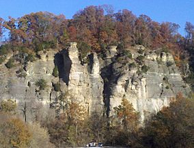
The steep bluffs on the eastern side, overlooking the Big Muddy River, were not good for growing crops. Much of the soil from these bluffs has washed away into the river. Farmers might have tried to let their livestock graze here because of the good water and mild weather.
The Shawnee National Forest was created in 1939. Later, in 1990, the Illinois Wilderness Act set aside seven separate pieces of land within this National Forest as wilderness areas. The Clear Springs Wilderness is one of these areas. It is a place where there are no roads.
Neighboring Wilderness Areas
The Clear Springs Wilderness is next to the Bald Knob Wilderness. Bald Knob is to the south and east. Hutchins Creek separates these two wilderness areas. Both are managed by the United States Forest Service. You can explore them using the forest's River to River Trail.
Exploring the Wilderness and Snake Road
If you want to visit, you can drive north from Wolf Lake for about 3.5 miles (5.5 km) on Illinois Route 3. You will reach the old town of La Rue, Illinois. From there, a local road goes east. This road has many sharp turns as it climbs up the bluff to the edge of the wilderness area.
This local road is officially called LaRue Road. But many people call it Snake Road. This is because a large number of snakes use the road when they move between different areas during the seasons. Because of the snakes, this road is often closed to cars.
Snakes and Birds
Some of the snake species you might find here include the black rat snake, common king snake, rough green snake, and western ribbon snake. There are also two venomous snakes: the copperhead and the cottonmouth.
The LaRue-Pine Hills area is also known as an Important Bird Area of Illinois. This means it's a very important place for many different kinds of birds.
 | Laphonza Butler |
 | Daisy Bates |
 | Elizabeth Piper Ensley |


