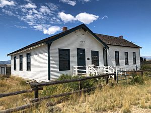
Coalmont, Colorado facts for kids
Quick facts for kids
Coalmont, Colorado
|
|
|---|---|
| Country | |
| State | |
| County | Jackson County |
| Elevation | 8,216 ft (2,504 m) |
| Time zone | UTC-7 (MST) |
| • Summer (DST) | UTC-6 (MDT) |
| ZIP Code |
80480
|
Coalmont is a small place in Jackson County, Colorado, United States. It's called an unincorporated community, which means it's not officially a town or city with its own local government. It also has a U.S. Post Office.
The name Coalmont comes from the large lignite coal mines nearby. Lignite coal is a type of soft coal. This coal was dug up and then sent by train on the Union Pacific Railroad to a main railway line in Laramie, Wyoming.
Contents
Where is Coalmont?
Coalmont is located at a specific spot on the map: 40°33′45″N 106°26′40″W / 40.5625°N 106.4444°W. It sits at a high elevation of about 8,216 feet above sea level. That's pretty high up!
What's the Weather Like?
A weather station called Spicer is about 6 miles (9.7 km) south of Coalmont. It's even higher up, at 8,385 feet (2,556 meters). The weather there is mostly a subalpine climate. This means it has very cold, snowy winters and mild summers. It's also a bit like a humid continental climate, which has bigger differences between summer and winter temperatures.
| Climate data for Spicer, Colorado, 1991–2020 normals, 1912-2020 extremes: 8385ft (2556m) | |||||||||||||
|---|---|---|---|---|---|---|---|---|---|---|---|---|---|
| Month | Jan | Feb | Mar | Apr | May | Jun | Jul | Aug | Sep | Oct | Nov | Dec | Year |
| Record high °F (°C) | 56 (13) |
65 (18) |
80 (27) |
73 (23) |
82 (28) |
90 (32) |
91 (33) |
91 (33) |
90 (32) |
78 (26) |
70 (21) |
75 (24) |
91 (33) |
| Mean maximum °F (°C) | 43.6 (6.4) |
45.3 (7.4) |
53.0 (11.7) |
63.6 (17.6) |
72.5 (22.5) |
80.2 (26.8) |
84.0 (28.9) |
82.2 (27.9) |
78.2 (25.7) |
68.6 (20.3) |
54.5 (12.5) |
44.0 (6.7) |
83.2 (28.4) |
| Mean daily maximum °F (°C) | 28.5 (−1.9) |
31.1 (−0.5) |
39.5 (4.2) |
49.2 (9.6) |
59.4 (15.2) |
71.0 (21.7) |
76.6 (24.8) |
75.6 (24.2) |
68.3 (20.2) |
55.3 (12.9) |
38.7 (3.7) |
29.1 (−1.6) |
51.9 (11.0) |
| Daily mean °F (°C) | 17.9 (−7.8) |
20.2 (−6.6) |
27.5 (−2.5) |
36.1 (2.3) |
44.8 (7.1) |
53.3 (11.8) |
59.3 (15.2) |
58.1 (14.5) |
51.2 (10.7) |
39.9 (4.4) |
27.2 (−2.7) |
18.9 (−7.3) |
37.9 (3.3) |
| Mean daily minimum °F (°C) | 7.3 (−13.7) |
9.3 (−12.6) |
15.4 (−9.2) |
22.9 (−5.1) |
30.1 (−1.1) |
35.6 (2.0) |
42.0 (5.6) |
40.5 (4.7) |
34.1 (1.2) |
24.6 (−4.1) |
15.8 (−9.0) |
8.8 (−12.9) |
23.9 (−4.5) |
| Mean minimum °F (°C) | −17.5 (−27.5) |
−18.7 (−28.2) |
−9.0 (−22.8) |
2.7 (−16.3) |
15.5 (−9.2) |
24.4 (−4.2) |
31.1 (−0.5) |
30.1 (−1.1) |
16.4 (−8.7) |
4.9 (−15.1) |
−9.1 (−22.8) |
−18.2 (−27.9) |
−25.3 (−31.8) |
| Record low °F (°C) | −48 (−44) |
−50 (−46) |
−36 (−38) |
−17 (−27) |
0 (−18) |
11 (−12) |
19 (−7) |
20 (−7) |
0 (−18) |
−14 (−26) |
−32 (−36) |
−43 (−42) |
−50 (−46) |
| Average precipitation inches (mm) | 0.97 (25) |
1.08 (27) |
1.23 (31) |
1.62 (41) |
1.53 (39) |
1.02 (26) |
1.54 (39) |
1.26 (32) |
1.71 (43) |
1.16 (29) |
1.06 (27) |
0.97 (25) |
15.15 (384) |
| Average snowfall inches (cm) | 17.5 (44) |
20.5 (52) |
19.6 (50) |
15.7 (40) |
5.9 (15) |
0.3 (0.76) |
0.0 (0.0) |
0.0 (0.0) |
1.0 (2.5) |
7.2 (18) |
18.4 (47) |
19.5 (50) |
125.6 (319.26) |
| Average precipitation days (≥ 0.01 in) | 9.0 | 8.3 | 7.6 | 9.5 | 9.4 | 7.7 | 8.8 | 11.0 | 8.7 | 6.4 | 8.7 | 7.3 | 102.4 |
| Average snowy days (≥ 0.1 in) | 8.3 | 7.4 | 7.3 | 6.4 | 1.9 | 0.3 | 0.0 | 0.0 | 0.5 | 2.8 | 8.3 | 8.0 | 51.2 |
| Source 1: NOAA (1981-2010 snowfall & snow days) | |||||||||||||
| Source 2: XMACIS2 (records & 1981-2010 monthly max/mins) | |||||||||||||
What is the Coalmont Formation?
Coalmont, Colorado, is known in geology as the type locality for something called the Coalmont Formation. This means that the rocks and land around Coalmont are the best place to study and understand this specific type of rock layer. Geologists use this area as the main example when they talk about the Coalmont Formation.
Coal Mining in Coalmont
Coalmont was once a busy town because of the coal mines nearby. People started digging for coal here in 1909. This mining continued until the end of World War II. After the war, the mines stopped working for a while.
In 1959, a new type of mine, called an open-pit mine, was opened. Some coal was dug up and sold in Denver, Colorado. However, this new mining only lasted for a year or two. Since then, no more coal has been produced, even though some people looked for coal in 1964 and 1965.
In 1941, the mines produced a lot of coal, about 1,438,355 tons. It was estimated that there were still 177,450,000 tons of soft coal left underground.
 | Sharif Bey |
 | Hale Woodruff |
 | Richmond Barthé |
 | Purvis Young |


