Coalstoun Lakes, Queensland facts for kids
Quick facts for kids Coalstoun LakesQueensland |
|||||||||||||||
|---|---|---|---|---|---|---|---|---|---|---|---|---|---|---|---|

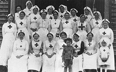
Red Cross workers on Red Cross Day, 19 July 1918
|
|||||||||||||||
| Population | 99 (2021 census) | ||||||||||||||
| • Density | 1.908/km2 (4.94/sq mi) | ||||||||||||||
| Postcode(s) | 4621 | ||||||||||||||
| Area | 51.9 km2 (20.0 sq mi) | ||||||||||||||
| Time zone | AEST (UTC+10:00) | ||||||||||||||
| Location | |||||||||||||||
| LGA(s) | North Burnett Region | ||||||||||||||
| State electorate(s) | Callide | ||||||||||||||
| Federal Division(s) | Flynn | ||||||||||||||
|
|||||||||||||||
Coalstoun Lakes is a small rural town in the North Burnett Region of Queensland, Australia. It's also the name of the area around the town. In 2021, only 99 people lived in Coalstoun Lakes. It's known for its unique volcanic lakes.
Contents
Exploring Coalstoun Lakes
The main road, called the Isis Highway, goes right through Coalstoun Lakes. In the town, it's known as Main Street. You can find the Coalstoun Lakes National Park in the north-east part of the area. This park is home to the special lakes that gave the town its name.
A Look Back in Time
The lakes in Coalstoun Lakes were named in 1894 by an early settler, Nugent Wade Brown. There are a few ideas about where the name Coalstoun came from:
- Some people think it's a changed version of an Aboriginal word, Goanalganai.
- Another idea is that it comes from 'Colstoun', the name of a property in New South Wales. This property belonged to Nugent Wade Brown's family.
- It could also be named after Colstoun in Scotland. This was the original home of the Brown family.
The Coalstoun Lakes Cemetery is very old. The earliest grave found there is from 1899, which is even older than the town itself!
The first school in the area, Coalstoun Lakes State School, opened its doors on 25 July 1910. Other schools, like Brigalow Creek State School (1913-1924) and Mount Harvey State School (1921-1948), also served the community for a time.
The Coalstoun Lakes Community Hall was built in 1916. After World War I, it was made bigger and renamed the Coalstoun Lakes Memorial Hall. This was done to remember the brave people who served in the war.
The town also had a Post Office that opened in 1927 and closed in 1976. Churches were built too, with a Catholic church opening in 1932 and St Thomas' Anglican Church in 1934.
Important Places in Coalstoun Lakes
Coalstoun Lakes has some places that are important to its history. These are called heritage-listed sites:
- The Coalstoun Lakes Cemetery, located at the corner of Glenview Street and Cemetery Road.
- The Coalstoun Lakes Memorial Hall, found at the corner of Isis Highway and Glenview Street.
Learning in Coalstoun Lakes
Coalstoun Lakes State School is a primary school for students from Prep to Year 6. It's located at 3 Main Street (25°36′44″S 151°53′24″E / 25.6121°S 151.8901°E).
For high school, students usually travel to nearby towns. The closest secondary schools are Biggenden State School (up to Year 10) in Biggenden or Burnett State College (up to Year 12) in Gayndah.
Community Facilities
The Coalstoun Lakes Memorial Hall at 34 Main Street (25°36′56″S 151°53′23″E / 25.6155°S 151.8896°E) is a central meeting place. The local fire brigade also operates from a shed behind the hall.
St Thomas' Community Church at 11 Main Street (25°36′50″S 151°53′25″E / 25.61377°S 151.89031°E) is a former Anglican church that now serves the community.
The Coalstoun Lakes Cemetery (25°36′53″S 151°53′12″E / 25.6148°S 151.8867°E) is at the end of Coalstoun Lakes Cemetery Road.
 | Jewel Prestage |
 | Ella Baker |
 | Fannie Lou Hamer |


