Cockburn Island (Ontario) facts for kids
Quick facts for kids
Cockburn Island
|
|
|---|---|
|
Township municipality (single-tier)
|
|
| Township of Cockburn Island | |

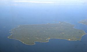
Aerial view of Cockburn Island
|
|
| Country | Canada |
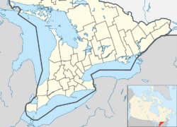
| Province | Ontario |
| Region | Northeastern Ontario |
| District | Manitoulin |
| Settled | ca. 1880 |
| Area | |
| • Land | 171.04 km2 (66.04 sq mi) |
| Population
(2021)
|
|
| • Total | 16 |
| • Density | 0/km2 (0/sq mi) |
| Time zone | UTC-5 (EST) |
| • Summer (DST) | UTC-4 (EDT) |
| Postal Code FSA |
P0P
|
| Area code(s) | 705, 249 |

Cockburn Island is an island and a special kind of town called a township municipality in Ontario, Canada. It's part of the Manitoulin District. The island is separated from Manitoulin Island by the Mississagi Strait. It is also near Michigan's Drummond Island.
Even though the island has about 90 cottages, most people only visit in the summer. During summer, the population can be around 200 to 300 people. However, only one person lives on the island all year round. This person works for the township, taking care of things. Because of this, official counts sometimes show the population as zero. Long ago, up to 1,000 people lived here permanently. But after the regular ferry service stopped in the 1960s, it became mostly a summer vacation spot.
Contents
Island History: From Logging to Leisure
Sources aren't sure if the island was named after Francis Cockburn, a military officer, or Isaac Cockburn, an early landowner.
Early Settlements and Growth
The first people to settle on the island were farmers in an area called Scotch Block. Later, in 1878, a fisherman named Siberon "Zeke" Tolsma started the community of Tolsmaville. By 1879, a steamboat ferry connected the island to other places. The township government was officially formed in 1881. A better shipping dock was built in 1888.
Schools were built in Tolsmaville in 1882 and in Scotch Block in 1884.
After a new law in 1898, the island's logging industry grew a lot. This law said that raw logs had to be processed into lumber locally. New sawmills opened, not just in Tolsmaville, but also in a new community called Ricketts Harbour. The island's population reached its highest point, about 1,000 people, around the time of World War II.
Becoming a Summer Getaway
In the 1960s, the main ferry service stopped. This made it much harder to get to Cockburn Island. The population quickly started to shrink because of this isolation. Harold McQuarry, who used to run the island's general store, became the new leader, called a reeve. Many people say his efforts helped the island survive as a popular summer community.
By the 1980s, only Lee Chappell, a maintenance worker for the island's government, and his wife Lynne lived there full-time. Lee retired in 2000, and Darren Rogers took over. He also lived on the island as of 2014.
Tolsmaville is still the main spot for summer visitors. Even though some people mistakenly call it a ghost town, it's quite active in the summer. Fun events include an annual fish fry in August and a community potluck on Labour Day weekend.
Besides the family cottages, the island is also a popular place for camping. Some logging still happens on the island. A large part of the island is protected by the Nature Conservancy of Canada to keep it natural.
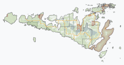
A small part of the island's northwest side is a special area for the Zhiibaahaasing First Nation. It's called Zhiibaahaasing 19. Even though it was added to Cockburn Island Township for census counting in 2010, the land is still set aside for the First Nation.
Getting to Cockburn Island
Cockburn Island is not connected to other islands or the mainland by a bridge or ferry service. The only ways to get there are by private boat in the summer or by snowmobile in the winter. You can also fly in using a float plane or a helicopter.
The township has a marina (a place for boats) in Tolsmaville. There's also a small grass airstrip west of Tolsmaville for planes.
Recently, the township worked on making a road near Tolsmaville safer. They also saved some rocks for a future project to fix the breakwater that protects the marina.
Island Population Facts
In the 2021 Census, Cockburn Island had a population of 16 people. These people lived in 11 of the 89 available homes. This was a change from 2016, when the official population was 0. The island has a land area of about 168.9 square kilometers.


