
Coco Islands facts for kids
|
Native name:
ကိုကိုးကျွန်း (Burmese)
|
|
|---|---|

Coco Islands
Location in Myanmar

Coco Islands
Location in Bay of Bengal
Location of Coco Islands in Myanmar and in the Bay of Bengal
|
|
| Geography | |
| Location | Bay of Bengal |
| Coordinates | 14°03′N 93°21′E / 14.05°N 93.35°E |
| Archipelago | Coco Islands |
| Adjacent bodies of water | Andaman Sea |
| Total islands | 7 |
| Major islands |
|
| Area | 7.93 sq mi (20.5 km2) |
| Length | 6.2 mi (10 km) |
| Highest elevation | 366 ft (111.6 m) |
| Administration | |
| Region | Yangon |
| District | South Yangon |
| Township | Cocokyun |
| Ward | Coco Islands |
| Largest settlement | Great Coco Island (pop. 1,000+) |
| Demographics | |
| Population | Less than 1,109 (2019) |
| Pop. density | 54 /sq mi (20.8 /km2) |
| Ethnic groups | Bamar people, non-Burmese minorities |
| Additional information | |
| Time zone |
|
| ISO code | MM-06 |
The Coco Islands (Burmese: ကိုကိုးကျွန်း) are a small group of islands located in the northeastern part of the Bay of Bengal. These islands have been part of the Yangon Region of Myanmar since 1937. They are about 414 kilometers (257 miles) south of the city of Yangon.
The Coco Island group includes five islands. Four of them are on the Great Coco Reef, and one is on the Little Coco Reef. To the north of these islands is Preparis Island, which also belongs to Myanmar. To the south, you'll find Landfall Island, which is part of India.
Contents
History of the Coco Islands
The Coco Islands were once an important stop on old trade routes between India, Burma (now Myanmar), and Southeast Asia. Ships often visited them. In the 1500s, Portuguese sailors named the islands "Coco" because of the many coconuts found there. "Coco" is the Portuguese word for coconut.
In the 1700s, the East India Company, a powerful British trading company, took control of the islands. Later, they became part of the British Raj, which was British rule in India. The Coco Islands were important for providing food, especially coconuts, to a penal colony (a prison settlement) in Port Blair. This prison was on South Andaman Island and was set up in 1858 for prisoners from the Indian Rebellion of 1857.
In the 1860s, a family called Jadwet leased the islands and built a lighthouse on Table Island. However, the islands were so far away that it took a very long time for news to reach officials in India. Because of this, control of the islands was given to British Burma by 1882. Attempts to develop the islands for business over the next 60 years were not successful.
When Burma became a crown colony (a territory controlled by the British Crown) in 1937, it kept the Coco Islands. During the Second World War, from 1942 to 1945, Japan took over the islands.
After Independence
Burma gained its independence in 1948 and kept control of the Coco Islands. In January 1959, the government led by Ne Win started a prison for political prisoners on Great Coco Island. After Ne Win's military takeover in 1962, this prison became known as a harsh place, sometimes called Burma's "Devil’s Island". After three hunger strikes by prisoners between 1969 and 1971, the prison was closed in December 1971. The facilities were then given to the Burmese Navy.
In 1998, India's Defence Minister, George Fernandes, claimed that China had leased the islands in 1994. However, no proof of this claim has ever been found.
Military Presence
In 1992, a Japanese news agency reported that China was helping to improve the military base on Great Coco Island. Throughout the 1990s and 2000s, some journalists and experts suggested that China had a large base there for signals intelligence (collecting information by listening to electronic signals). They thought this was part of China's "string of pearls" strategy, which involves building influence in the Indian Ocean.
In 1998, George Fernandes also claimed that China planned to build a major naval base on the islands. India was the only country to publicly say that a Chinese base existed. However, no evidence to support this claim appeared by 2008. Both China and Burma (Myanmar) denied that such a base existed. In 1998, the United States also reported that there was no major Chinese activity on the islands. In 2005, India changed its position after inspecting the islands at Myanmar's invitation.
In 2014, Air Marshal P. K. Roy, a commander in India's military, said that "China has been developing a runway for civilian purposes. There are no reports of the presence of Chinese per se. The situation is not alarming." He added that only some civilian buildings were being developed, which were not a threat to India.
Recent satellite images from January 2023 show that the Coco Island Airport has been upgraded. These upgrades include a longer 2,300-meter (7,500-foot) runway, a radar tower, and two new airplane hangars. It seems that the Tatmadaw (Myanmar military) runs this facility, and there is no clear sign of Chinese military presence.
Geography of the Islands
The Bay of Bengal is to the west of the Coco Islands, and the Andaman Sea is to the east. The main part of Myanmar is about 250 kilometers (155 miles) to the north. The island of Preparis is about 77 kilometers (48 miles) to the north-northeast of the Coco Islands.
The Coco Islands group includes three main islands: Great Coco Island, the smaller Little Coco Island (separated by the Alexandra Channel), and Table Island, which is close to Great Coco Island.
Geographically, these islands are part of the Andaman and Nicobar Islands chain, most of which belongs to India. The Coco Islands are separated from Landfall Island (the northernmost Indian island in the chain) by the 20-kilometer (12-mile) wide Coco Channel.
Great Coco Reef Islands
This reef has four islands. From north to south, they are Slipper Island, Table Island, Great Coco Island, and Jerry Island.
Great Coco Island
Great Coco Island is about 10.4 kilometers (6.5 miles) long and 2 kilometers (1.2 miles) wide. Many green turtles lay their eggs on the beaches of this island. Myanmar's Ministry of Livestock, Fisheries, and Rural Development has done research to help protect these marine turtles. In 2006, scientists collected samples from green turtles to study their genetics and track their movements. Before this, Great Coco Island had not been surveyed for marine turtle conservation because it was so remote. The survey found an estimated 150 sea turtles nesting and about 95,000 baby turtles and young turtles.
Table Island
Table Island is shaped like an axe head and is about 2.5 kilometers (1.6 miles) north of Great Coco Island. It is 1.6 kilometers (1 mile) long and 1.2 kilometers (0.75 miles) wide. This island used to have a lighthouse on its southwestern side, but it is now uninhabited. The lighthouse was built in 1867 and is painted with red and white stripes. It has a lantern and a walkway around it. Two brick houses where the lighthouse keepers lived are also nearby. You can reach the island by boat.
Slipper Island
Slipper Island is a narrow islet about 0.4 kilometers (0.25 miles) long. It is located off the northwestern tip of Table Island, separated by a narrow channel about 0.2 kilometers (0.12 miles) wide.
Jerry Island
Jerry Island is an islet about 1.1 kilometers (0.68 miles) long and 0.2 kilometers (0.12 miles) wide. It is located off the southern tip of Great Coco Island. You can walk to Jerry Island from Great Coco Island across a sandbar that connects them.
Little Coco Reef Island
This reef has only one island.
Little Coco Island
Little Coco Island is about 16 kilometers (10 miles) southwest of Great Coco Island. It is 5 kilometers (3.1 miles) long from north to south and 1.2 kilometers (0.75 miles) wide from east to west. This island is on its own separate reef, while the other four islands (including Table Island) are on the same reef as Great Coco Island. Little Coco Island is the southernmost island of Myanmar in the Andaman and Nicobar Sea. The next island to the south is Landfall Island, which belongs to India.
General Information About the Islands
| Island | Location | Features | Area (km2) | Population |
|---|---|---|---|---|
| Great Coco Island | 14°06′00″N 93°21′54″E / 14.10°N 93.365°E | Airport, coconut groves | 14.57 | 1000+ |
| Little Coco Island | 13°59′17″N 93°13′30″E / 13.988°N 93.225°E | Coconut groves | 4.44 | 150 |
| Table Island | 14°11′06″N 93°21′54″E / 14.185°N 93.365°E | Lighthouse | 1.28 | 0 |
| Slipper Island | 14°11′24″N 93°21′25″E / 14.19°N 93.357°E | 0.08 | 0 | |
| Rat Island | 14°07′41″N 93°22′55″E / 14.128°N 93.382°E | 0.015 | 0 | |
| Binnacle Rock | 14°09′00″N 93°22′19″E / 14.15°N 93.372°E ACoordinates: Extra unexpected parameters Invalid arguments have been passed to the {{#coordinates:}} function |
0.011 | 0 | |
| Jerry Island | 14°03′00″N 93°21′54″E / 14.05°N 93.365°E | 0.14 | 0 | |
| Coco Islands (Total) | 20.53 | 1350+ |
People of the Coco Islands
There are more than 200 houses on Great Coco Island, and its total population is around a thousand people. A large water storage area helps provide water for the island's residents.
There is also a naval base on the islands, which belongs to the 28th unit of the Myanmar Navy. About 200 soldiers and their families live there.
Climate
The Coco Islands have a tropical monsoon climate (which is called Am in the Köppen climate classification). This means temperatures are very warm all year round. There is a dry season in winter from December to March. The summer wet season lasts from April to November, bringing a lot of rain. For example, in September, it has been known to rain as much as 761 millimeters (30 inches).
| Climate data for Coco Islands (1981–2010) | |||||||||||||
|---|---|---|---|---|---|---|---|---|---|---|---|---|---|
| Month | Jan | Feb | Mar | Apr | May | Jun | Jul | Aug | Sep | Oct | Nov | Dec | Year |
| Mean daily maximum °C (°F) | 29.6 (85.3) |
30.0 (86.0) |
31.0 (87.8) |
32.6 (90.7) |
32.3 (90.1) |
30.7 (87.3) |
30.3 (86.5) |
30.0 (86.0) |
30.2 (86.4) |
30.8 (87.4) |
31.0 (87.8) |
30.0 (86.0) |
30.7 (87.3) |
| Daily mean °C (°F) | 25.8 (78.4) |
25.6 (78.1) |
26.6 (79.9) |
28.5 (83.3) |
29.0 (84.2) |
28.1 (82.6) |
27.6 (81.7) |
27.5 (81.5) |
27.4 (81.3) |
27.6 (81.7) |
27.7 (81.9) |
26.6 (79.9) |
27.3 (81.1) |
| Mean daily minimum °C (°F) | 22.0 (71.6) |
21.2 (70.2) |
22.0 (71.6) |
24.3 (75.7) |
25.8 (78.4) |
25.4 (77.7) |
25.0 (77.0) |
25.0 (77.0) |
24.6 (76.3) |
24.4 (75.9) |
24.4 (75.9) |
23.2 (73.8) |
23.9 (75.0) |
| Average precipitation mm (inches) | 2.2 (0.09) |
5.2 (0.20) |
13.2 (0.52) |
37.0 (1.46) |
240.0 (9.45) |
456.3 (17.96) |
418.3 (16.47) |
438.8 (17.28) |
380.2 (14.97) |
184.3 (7.26) |
138.3 (5.44) |
23.0 (0.91) |
2,336.8 (92.00) |
| Average precipitation days (≥ 1.0 mm) | 0.3 | 0.2 | 0.7 | 2.4 | 12.2 | 19.9 | 20.2 | 20.4 | 18.6 | 13.7 | 7.5 | 1.4 | 117.6 |
| Source 1: Norwegian Meteorological Institute | |||||||||||||
| Source 2: World Meteorological Organization | |||||||||||||
Administration
The Coco Islands are part of the township called Cocokyun. In the 2015 Myanmar general election, there were some problems with how votes were handled in this township, which led to a police investigation.
Transportation
The Coco Island Airport (ICAO code: VYCI) is located at the north end of Great Coco Island. Its runway is about 1,800 meters (5,900 feet) long and runs from north to south, near the island's main village. The airport has been recently updated.
Plants and Animals
The Coco Islands are home to special reptiles, birds, and mammals that are found only there. This makes the islands a unique place for nature lovers.
Images for kids
-
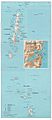
Map of the Andaman and Nicobar Islands, with the Coco Islands in the extreme north
-
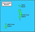
Map of the Coco Islands group, Great Coco Island in north and Little Coco Island in southwest
-
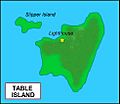
Map of Table Island in the middle and Slipper Island to the northwest
-
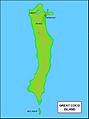
Map of Great Coco Island with tiny Jerry Island at the bottom
-
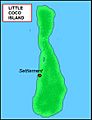
Map of Little Coco Island, it is the southernmost island of Myanmar


See also
 In Spanish: Islas Coco para niños
