Columbine Valley, Colorado facts for kids
Quick facts for kids
Columbine Valley, Colorado
|
|
|---|---|
| Town of Columbine Valley | |

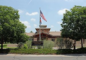
The Columbine Valley Town Hall.
|
|

Location of the Town of Columbine Valley in Arapahoe County, Colorado.
|
|
| Country | |
| State | |
| County | Arapahoe County |
| Incorporated | July 2, 1959 |
| Government | |
| • Type | Statutory Town |
| Area | |
| • Total | 0.993 sq mi (2.573 km2) |
| • Land | 0.982 sq mi (2.543 km2) |
| • Water | 0.012 sq mi (0.030 km2) |
| Elevation | 5,344 ft (1,629 m) |
| Population
(2020)
|
|
| • Total | 1,502 |
| • Density | 1,530/sq mi (590/km2) |
| • Metro | 2,963,821 (19th) |
| • CSA | 3,623,560 (17th) |
| • Front Range | 5,055,344 |
| Time zone | UTC−07:00 (MST) |
| • Summer (DST) | UTC−06:00 (MDT) |
| ZIP Code |
80123
|
| Area code(s) | Both 303 and 720 |
| FIPS code | 08-16385 |
| GNIS feature ID | 0182642 |
The Town of Columbine Valley is a small town in Colorado, United States. It is located in the western part of Arapahoe County. In 2020, about 1,502 people lived there. This was a nearly 20% increase in population since 2010. Columbine Valley is part of the larger Denver-Aurora-Lakewood, CO Metropolitan Statistical Area. It is also part of the Front Range Urban Corridor, which is a busy area in Colorado.
Geography of Columbine Valley
Columbine Valley is located at 39°35′58″N 105°2′14″W / 39.59944°N 105.03722°W. This tells us its exact spot on a map.
In 2020, the town covered an area of about 2.573 square kilometers (about 1 square mile). A small part of this area, about 0.030 square kilometers, is water.
Population and People
| Historical population | |||
|---|---|---|---|
| Census | Pop. | %± | |
| 1970 | 481 | — | |
| 1980 | 923 | 91.9% | |
| 1990 | 1,071 | 16.0% | |
| 2000 | 1,132 | 5.7% | |
| 2010 | 1,256 | 11.0% | |
| 2020 | 1,502 | 19.6% | |
| U.S. Decennial Census | |||
The population of Columbine Valley has grown over the years. In 2010, there were 1,256 people living in the town. These people lived in 491 households. Most of the households, 421, were families.
Most people in Columbine Valley are White (95.3%). A smaller number of people are Asian (1.5%), African American (0.7%), or Native American (0.4%). About 1.5% of the population identified as two or more races. People of Hispanic or Latino background made up 2.1% of the population.
Many households in Columbine Valley are made up of married couples. About 26.5% of households had children under 18 living there. The average household had about 2.56 people. The average family had about 2.79 people.
The town's population has a mix of ages. About 21.1% of residents were under 18 years old. About 22.3% were 65 years or older. The median age in 2010 was 52.5 years. This means half the people were younger than 52.5 and half were older. The population was almost evenly split between males (49.7%) and females (50.3%).
Schools in the Area
The schools in Columbine Valley are part of the Littleton School District 6.
Students living in Columbine Valley attend specific schools based on where they live.
- Elementary school students go to Wilder Elementary School.
- Middle school students attend Goddard Middle School.
- High school students go to Heritage High School.
See also
 In Spanish: Columbine Valley para niños
 | Toni Morrison |
 | Barack Obama |
 | Martin Luther King Jr. |
 | Ralph Bunche |


