Combaning, New South Wales facts for kids
Quick facts for kids CombaningNew South Wales |
|
|---|---|

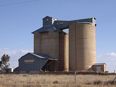
Silos at Combaning
|
|
| Population | 100 (2021 census) |
| Postcode(s) | 2666 |
| Elevation | 303 m (994 ft) |
| Location |
|
| LGA(s) | Temora Shire |
| County | Bland |
| State electorate(s) | Cootamundra |
| Federal Division(s) | Riverina |
Combaning is a small country community located in the north-east part of the Riverina region in New South Wales, Australia. It's a quiet place, about 3 kilometres west of Springdale and 13 kilometres east of Temora. According to the 2021 census, only 100 people lived in Combaning, making it a very small and peaceful spot!
The name Combaning has a special meaning. It comes from the local Aboriginal people, specifically the Yuin language. In their language, "Combaning" means 'to hold water'. This name might tell us something interesting about how water was important in this area long ago.
Combaning's Railway History
Combaning once had its own railway station. This station was part of a special train line that went to Lake Cargelligo. It helped connect the community to other places for many years.
When the Station Operated
The Combaning railway station was open for a long time. It started operating in 1893. Trains used to stop there, carrying people and goods. The station closed down in 1975.
| Preceding station | Former Services | Following station | ||
|---|---|---|---|---|
| Temora
towards Lake Cargelligo
|
Lake Cargelligo Line | Springdale
towards Cootamundra
|
||


