Combe Hay Locks facts for kids

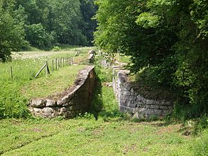
The chambers of locks 14, 13 and 12
|
|
| Waterway | Somerset Coal Canal |
|---|---|
| Country | United Kingdom |
| County | Somerset |
| Operation | Manual |
| First built | 1805 |
| Length | 1.6 miles (2.6 km) |
| Width | 7 feet (2.1 m) |
| Fall | 134 feet (41 m) |
| Distance to Kennet and Avon Canal |
3.5 miles (5.6 km) |
| Distance to Timsbury Basin |
6.25 miles (10.06 km) |
| Coordinates | 51°20′39″N 2°22′13″W / 51.3443°N 2.3702°W |
The Combe Hay Locks are a set of old, unused canal locks located near Combe Hay, Somerset, in the United Kingdom. These locks were part of the Somerset Coal Canal. They helped boats climb a big hill.
There were 22 locks in total. They raised the canal 134 feet (about 41 meters) over a distance of 1.6 miles (about 2.6 kilometers). Before these locks were built, people tried other ways to lift boats up the hill. These included special "caisson locks" and an "inclined plane." The Combe Hay Locks opened in 1805 and were used until 1899.
Contents
History of the Locks
The Somerset Coal Canal followed the path of the Midford Brook and then the Cam Brook. When it reached Combe Hay, the valley became very steep. The canal needed a way to climb 134 feet (41 meters) in a short distance.
Trying Caisson Locks
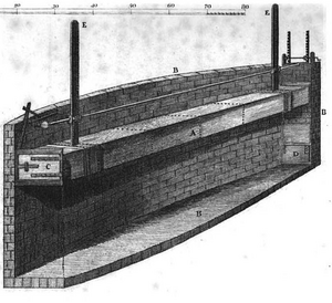
The first idea to get boats up the steep hill was to use three caisson locks. A caisson lock is like a giant moving box that lifts boats. Imagine a huge elevator for boats!
Building the first caisson lock started in 1796. It had a large stone chamber, like a big pool, that was 81 feet (25 meters) long and 61.5 feet (19 meters) deep. Inside this chamber was a wooden box, the caisson, which was 80 feet (24 meters) long. Each caisson lock was designed to lift boats 46 feet (14 meters).
Tests of the first lock happened in 1797 and 1798. People said a boat could go through it in just 7 minutes. One newspaper even claimed a 12-year-old boy could operate it in 10 minutes!
However, there were big problems. The caisson box could not stay watertight, meaning water leaked out. Also, the ground in the area, which had a lot of fuller's earth, was too soft. In 1799, the stone walls of the lock chamber started to bulge, and the caisson got stuck. Fixing it would cost a lot of money, so the idea of caisson locks was given up in 1800.
Even though it failed, the caisson lock was a popular place to visit. The famous writer Jane Austen even planned a walk to see it in 1801.
The Inclined Plane
After the caisson locks failed, the canal company decided to build a series of regular locks. But they needed a quicker solution while the new locks were being built. So, they decided to build a temporary inclined plane.
An inclined plane is like a railway track that goes up a hill. Boats would be put on special cradles and pulled up or down the slope. This method was slow, but it helped keep the canal construction moving forward. The inclined plane started working in November 1801.
Building the Lock Flight
While the inclined plane was in use, construction began on the 22 new locks in November 1802. The first lock was finished in June 1804. Much of the stone from the old caisson lock was reused to build these new locks.
The engineer who designed the locks was probably William Bennet. The full set of 22 locks opened in April 1805. Each lock lifted boats about 6 feet (1.8 meters). They were 7 feet (2.1 meters) wide and long enough for a 70-foot (21-meter) narrowboat.
To fit all these locks into the landscape, the canal had to make a big turn, almost 170 degrees, like a hairpin bend. This turn became known as the "Bull's Nose." The locks were designed to fill and empty very quickly to save time.
Why the Locks Closed
In 1881, a railway line opened nearby. Like many canals, the arrival of trains meant fewer people used the canal. Trains were faster for moving goods.
The canal was put up for sale in 1894. By 1898, the pumps that supplied water to the locks stopped working. Without enough water, boats could not use the canal. In August 1899, the Combe Hay Locks officially stopped operating.
What Happened Next
After the canal was abandoned in 1899, the locks were left to fall apart. One lock, Lock 16, was even filled in because a railway bridge was built over it.
In the 1980s, many of the remaining locks were given Grade II listed status. This means they are important historical buildings and are protected. Surveys showed that the stone walls of the locks were still standing, some as high as 10 to 12 feet (3 to 3.7 meters). Some of the old wooden lock gates were even still there!
A building near the top of the locks, called Caisson House, is named after the first caisson lock. It was probably built as homes for canal workers in the 1830s.
Bringing Them Back to Life
Work to restore parts of the lower locks began in 2000. This effort expanded in 2011 to include the upper locks. Volunteers from the Inland Waterways Association's Waterway Recovery Group have been helping with this important work.
Where Are the Locks?
Here is a list of the locks and their locations:
| Feature | Coordinates | Status |
|---|---|---|
| Lock 1 | 51°20′24″N 2°22′33″W / 51.340005°N 2.375833°W | Still there |
| Lock 2 | 51°20′23″N 2°22′28″W / 51.339779°N 2.374577°W | Still there |
| Lock 3 | 51°20′24″N 2°22′25″W / 51.340030°N 2.373713°W | Still there |
| Lock 4 | 51°20′26″N 2°22′22″W / 51.340657°N 2.372686°W | Still there |
| Lock 5 | 51°20′29″N 2°22′20″W / 51.341324°N 2.372289°W | Still there |
| Lock 6 | 51°20′32″N 2°22′16″W / 51.342095°N 2.371101°W | Still there |
| Lock 7 | 51°20′33″N 2°22′14″W / 51.342422°N 2.370514°W | Still there |
| Lock 8 | 51°20′34″N 2°22′10″W / 51.342896°N 2.369334°W | Still there |
| Lock 9 | 51°20′36″N 2°22′10″W / 51.343471°N 2.369441°W | Still there |
| Lock 10 | 51°20′38″N 2°22′14″W / 51.344003°N 2.370496°W | Still there |
| Lock 11 | 51°20′40″N 2°22′14″W / 51.344412°N 2.370614°W | Still there |
| Lock 12 | 51°20′39″N 2°22′11″W / 51.344094°N 2.369670°W | Still there |
| Lock 13 | 51°20′38″N 2°22′07″W / 51.343826°N 2.368688°W | Still there |
| Lock 14 | 51°20′37″N 2°22′04″W / 51.343555°N 2.367693°W | Still there |
| Lock 15 | 51°20′35″N 2°22′01″W / 51.343160°N 2.367006°W | Still there |
| Lock 16 | 51°20′33″N 2°22′00″W / 51.342476°N 2.366732°W | Filled in |
| Lock 17 | 51°20′31″N 2°21′58″W / 51.341851°N 2.366118°W | Filled in |
| Lock 18 | 51°20′29″N 2°21′53″W / 51.341318°N 2.364664°W | Filled in |
| Lock 19 | 51°20′27″N 2°21′47″W / 51.340737°N 2.363065°W | Filled in |
| Lock 20 | 51°20′27″N 2°21′41″W / 51.340735°N 2.361297°W | Filled in |
| Lock 21 | 51°20′28″N 2°21′35″W / 51.341045°N 2.359728°W | Filled in |
| Lock 22 | 51°20′30″N 2°21′30″W / 51.341626°N 2.358357°W | Filled in |
 | Jackie Robinson |
 | Jack Johnson |
 | Althea Gibson |
 | Arthur Ashe |
 | Muhammad Ali |


