Comer, Georgia facts for kids
Quick facts for kids
Comer, Georgia
|
|
|---|---|

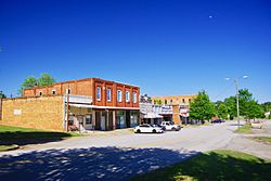
North Avenue
|
|
| Motto(s):
"Make Our Town Your Town"
|
|

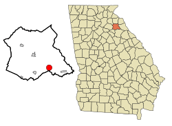
Location in Madison County and the state of Georgia
|
|
| Country | United States |
| State | Georgia |
| County | Madison |
| Area | |
| • Total | 3.26 sq mi (8.45 km2) |
| • Land | 3.24 sq mi (8.39 km2) |
| • Water | 0.03 sq mi (0.07 km2) |
| Elevation | 702 ft (214 m) |
| Population
(2020)
|
|
| • Total | 1,512 |
| • Density | 466.95/sq mi (180.32/km2) |
| Time zone | UTC−5 (Eastern (EST)) |
| • Summer (DST) | UTC−4 (EDT) |
| ZIP code |
30629
|
| Area code(s) | 706 |
| FIPS code | 13-19084 |
| GNIS feature ID | 0312868 |
Comer is a city located in Madison County, Georgia, in the United States. It's a smaller city, but it's the biggest one in Madison County. In 2020, about 1,512 people lived there. Comer is also part of the larger Athens-Clarke County area.
Contents
History of Comer
The city of Comer officially became a city on January 1, 1893. It was named after A. J. Comer, who was an important person in the early days of the community.
Geography and Location
Comer is found in the southeastern part of Madison County. It's located where several main roads meet: Georgia State Routes 72, 98, and 22.
The city is about 18 miles (29 km) southwest of Athens. Danielsville, which is the main town of Madison County, is 8 miles (13 km) to the northwest. Comer is also near the Broad River, which flows into the Savannah River. You can also find Watson Mill Bridge State Park nearby, just to the southeast.
Comer's Neighborhoods
Comer has several different areas where people live and work. These include:
- Downtown
- Jubilee
- Clairmont
- Brickyard
- Royal Oaks
- Shannons Place
- Village Station
- Arnold Park
- Spring Stone
- Hill Street
- Madison Street
- Clover Ave
- College Ave
- Laurel Ave
- Hawks View
Major Roads in Comer
Education in Comer
Students living in Comer attend schools that are part of the Madison County School District.
- Comer Elementary School (CES) is for younger students. Their mascot is the Comer Comets.
- Madison County Middle School (MCMS) is for middle schoolers. They are known as the Mustangs.
- Madison County High School (MCHS) is where older students go. Their team is the Red Raiders.
- Broad River College and Career Academy helps students prepare for college and different jobs.
There's also something called the Gholston Fund. It's a special fund set up by J. Knox Gholston to help pay for local education projects in Comer.
Population Changes Over Time
| Historical population | |||
|---|---|---|---|
| Census | Pop. | %± | |
| 1900 | 336 | — | |
| 1910 | 868 | 158.3% | |
| 1920 | 1,001 | 15.3% | |
| 1930 | 900 | −10.1% | |
| 1940 | 811 | −9.9% | |
| 1950 | 882 | 8.8% | |
| 1960 | 882 | 0.0% | |
| 1970 | 828 | −6.1% | |
| 1980 | 930 | 12.3% | |
| 1990 | 939 | 1.0% | |
| 2000 | 1,052 | 12.0% | |
| 2010 | 1,126 | 7.0% | |
| 2020 | 1,512 | 34.3% | |
| U.S. Decennial Census | |||
The population of Comer has changed over the years. In 2000, there were 1,052 people living in the city. By 2020, the population had grown to 1,512 people.
Healthcare Services
Comer Health and Rehabilitation Center is a facility that provides care for people who need short-term or long-term personal help. They offer services like physical therapy and wound care.
Jubilee Partners Community
Jubilee Partners is a Christian community located in Comer. It's a bit like Habitat for Humanity, which helps people build homes. Jubilee Partners was started in 1979. Their goal is to help others and serve the community.
Notable People from Comer
- Keith Strickland is a musician and composer. He is one of the original members of the famous band The B-52s.
See also
 In Spanish: Comer (Georgia) para niños
Images for kids
 | John T. Biggers |
 | Thomas Blackshear |
 | Mark Bradford |
 | Beverly Buchanan |


