Danielsville, Georgia facts for kids
Quick facts for kids
Danielsville, Georgia
|
|
|---|---|

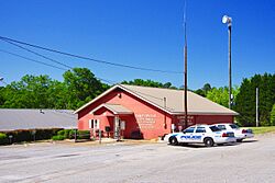
City hall
|
|

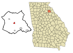
Location in Madison County and the state of Georgia
|
|
| Country | United States |
| State | Georgia |
| County | Madison |
| Area | |
| • Total | 1.48 sq mi (3.83 km2) |
| • Land | 1.45 sq mi (3.74 km2) |
| • Water | 0.03 sq mi (0.09 km2) |
| Elevation | 728 ft (222 m) |
| Population
(2020)
|
|
| • Total | 654 |
| • Density | 452.28/sq mi (174.68/km2) |
| Time zone | UTC-5 (Eastern (EST)) |
| • Summer (DST) | UTC-4 (EDT) |
| ZIP code |
30633
|
| Area code(s) | 706 |
| FIPS code | 13-21632 |
| GNIS feature ID | 0331511 |
Danielsville is a small city in Madison County, Georgia, United States. It's a friendly place with a population of 654 people, according to the 2020 census. This was a bit more than the 560 people counted in 2010. Danielsville is also special because it's the county seat of Madison County, which means it's where the main government offices for the county are located.
Contents
History of Danielsville
Danielsville got its name from a very important person, General Allen Daniel Jr. (1772–1836). He was a major general in the Georgia Militia from 1812 to 1817. He also served as a state senator and representative for Elbert and Madison counties. In 1822, he was even the Speaker of the Georgia House of Representatives.
In 1812, Danielsville was chosen to be the main town for the new Madison County. It officially became a town in 1817. Later, in 1908, it was recognized as a city.
Exploring Danielsville's Geography
Danielsville is located right in the middle of Madison County. You can find it at these coordinates: 34 degrees, 7 minutes, 27 seconds North and 83 degrees, 12 minutes, 59 seconds West.
The city is about 15 miles (24 km) northeast of Athens. It's also about the same distance southwest of Royston. These cities are connected by U.S. Route 29, a major road. Another road, Georgia State Route 98, goes through the northeastern part of Danielsville. This road leads northwest to Ila (about 5 miles or 8 km away) and southeast to Comer (about 8 miles or 13 km away).
Danielsville covers a total area of about 1.5 square miles (3.83 square kilometers). Most of this area is land, with a small part (about 0.03 square miles or 0.09 square kilometers) being water. The city's water flows into the South Fork of the Broad River. This river is part of the larger Savannah River system.
People of Danielsville
| Historical population | |||
|---|---|---|---|
| Census | Pop. | %± | |
| 1880 | 128 | — | |
| 1890 | 149 | 16.4% | |
| 1900 | 194 | 30.2% | |
| 1910 | 323 | 66.5% | |
| 1920 | 355 | 9.9% | |
| 1930 | 296 | −16.6% | |
| 1940 | 333 | 12.5% | |
| 1950 | 298 | −10.5% | |
| 1960 | 362 | 21.5% | |
| 1970 | 378 | 4.4% | |
| 1980 | 354 | −6.3% | |
| 1990 | 318 | −10.2% | |
| 2000 | 457 | 43.7% | |
| 2010 | 560 | 22.5% | |
| 2020 | 654 | 16.8% | |
| U.S. Decennial Census | |||
In 2000, Danielsville had 457 people living there. The population has grown over the years, reaching 654 people by 2020. The city is home to a mix of different people.
The average age in Danielsville in 2000 was 34 years old. About 22.8% of the population was under 18 years old. This shows that Danielsville is a community with people of all ages.
Education in Danielsville
Madison County School District
Students in Danielsville are part of the Madison County School District. This district provides education from pre-school all the way up to twelfth grade. It has a total of five elementary schools, one middle school, and one high school.
The district has many dedicated teachers, with about 290 full-time teachers. They teach over 4,621 students across all the schools.
Here are the schools in the district:
- Colbert Elementary School
- Comer Elementary School
- Danielsville Elementary School
- Hull-Sanford Elementary School
- Ila Elementary School
- Madison County Middle School
- Madison County High School
- Broad River College and Career Academy
Famous People from Danielsville
Some well-known individuals have connections to Danielsville:
- Crawford W. Long: He was born in Danielsville. He is famous for being the first person to use ether to help patients during surgery.
- Jake Westbrook: He is an American professional baseball player who played in Major League Baseball.
See also
 In Spanish: Danielsville (Georgia) para niños
 | Selma Burke |
 | Pauline Powell Burns |
 | Frederick J. Brown |
 | Robert Blackburn |

