Ila, Georgia facts for kids
Quick facts for kids
Ila, Georgia
|
|
|---|---|

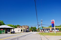
Main Street (SR 106)
|
|

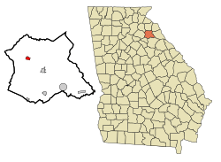
Location in Madison County and the state of Georgia
|
|
| Country | United States |
| State | Georgia |
| County | Madison |
| Area | |
| • Total | 0.77 sq mi (2.00 km2) |
| • Land | 0.77 sq mi (1.99 km2) |
| • Water | 0.00 sq mi (0.00 km2) |
| Elevation | 801 ft (244 m) |
| Population
(2020)
|
|
| • Total | 350 |
| • Density | 454.55/sq mi (175.49/km2) |
| Time zone | UTC-5 (Eastern (EST)) |
| • Summer (DST) | UTC-4 (EDT) |
| ZIP code |
30647
|
| Area code(s) | 706 |
| FIPS code | 13-40840 |
| GNIS feature ID | 0315877 |
Ila is a small city located in Madison County, Georgia, in the United States. In 2020, about 350 people lived there. It is a quiet community known for its history and location.
Contents
A Look Back: The History of Ila
Ila was first settled in the mid-1800s. Farmers from North Carolina and Virginia moved to the area. They created a community focused on farming.
People grew crops like corn, cotton, soybeans, and wheat. The area was important for agriculture.
The government of Georgia officially made Ila a town in 1910. The name "Ila" comes from the Choctaw language. It means "dead."
Where is Ila? Understanding its Geography
Ila is located in the northwestern part of Madison County. You can find it at these coordinates: 34°10′25″N 83°17′34″W / 34.17361°N 83.29278°W. The city is mainly around where two main roads meet: Georgia State Route 98 and Georgia State Route 106.
SR 106 goes south about 16 miles to Athens. It also goes north about 15 miles to Carnesville. SR 98 goes west about 10 miles to Commerce. It also goes southeast about 5 miles to Danielsville, which is the main town of Madison County.
The city covers about 0.8 square miles of land. Only a tiny part, about 0.13%, is water. Ila is on a ridge, which is like a raised line of land. It's between the South Fork of the Broad River to the south and Furnace Creek to the northeast. The city is part of the Savannah River watershed, meaning its water flows towards the Savannah River.
Who Lives in Ila? A Look at the Population
| Historical population | |||
|---|---|---|---|
| Census | Pop. | %± | |
| 1920 | 232 | — | |
| 1930 | 233 | 0.4% | |
| 1940 | 224 | −3.9% | |
| 1950 | 225 | 0.4% | |
| 1960 | 216 | −4.0% | |
| 1970 | 202 | −6.5% | |
| 1980 | 287 | 42.1% | |
| 1990 | 297 | 3.5% | |
| 2000 | 328 | 10.4% | |
| 2010 | 337 | 2.7% | |
| 2020 | 350 | 3.9% | |
| U.S. Decennial Census | |||
According to the census from 2000, there were 328 people living in Ila. These people lived in 137 households, and 86 of those were families.
Many types of households make up the city. About half of the households were married couples living together. Some households had a female head without a husband. Others were individuals living alone. About 14% of households had someone aged 65 or older living by themselves.
The population in Ila is spread across different age groups. About 23% of the people were under 18 years old. About 29% were between 25 and 44 years old. Around 12% of the population was 65 years or older. The average age in the city was 39 years.
See also
 In Spanish: Ila (Georgia) para niños
 | John T. Biggers |
 | Thomas Blackshear |
 | Mark Bradford |
 | Beverly Buchanan |


