Como, Minneapolis facts for kids
Quick facts for kids
Como
|
|
|---|---|
|
Neighborhood
|
|
 |
|
| Nickname(s):
Southeast Como
|
|

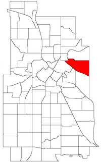
Location of Como within the U.S. city of Minneapolis
|
|
| Country | United States |
| State | Minnesota |
| County | Hennepin |
| City | Minneapolis |
| Community | University |
| Founded | 1882 |
| City Council Wards | 1, 2, 3 |
| Area | |
| • Total | 1.123 sq mi (2.91 km2) |
| Population
(2020)
|
|
| • Total | 6,455 |
| • Density | 5,748.0/sq mi (2,219.3/km2) |
| Time zone | UTC-6 (CST) |
| • Summer (DST) | UTC-5 (CDT) |
| ZIP code |
55414
|
| Area code(s) | 612 |
| Historical population | |||
|---|---|---|---|
| Census | Pop. | %± | |
| 1980 | 5,083 | — | |
| 1990 | 5,617 | 10.5% | |
| 2000 | 5,691 | 1.3% | |
| 2010 | 6,288 | 10.5% | |
| 2020 | 6,455 | 2.7% | |
Como is a neighborhood in the southeast part of Minneapolis. People sometimes call it Southeast Como. This helps tell it apart from the Como Park neighborhood in nearby Saint Paul.
Como is bordered by East Hennepin Avenue to the north. To the east is 33rd Avenue Southeast, which is the city limit. The Southeast Industrial Area is to the south. Interstate 35W is to the west. Como is also part of the University District. This is because it is close to the main campus of the University of Minnesota.
The neighborhood has many great places for people who live there. These include the Van Cleve Park Community Center. There is also the Como Student Community Co-op. The University Childcare Center is here too. You can find the Dar Al-Farooq mosque and SE Christian Church. The Como Congregational Church building was designed in 1886. It was created by Charles Sedgwick. The updated Bunge grain elevator tower is a key landmark. It is even shown in the neighborhood's logo.
Exploring Como: Location and Life
Como is mostly in Minneapolis City Council Ward 2. This area is represented by Robin Wonsley. A small part of the northern neighborhood is in Ward 1. This is represented by Elliott Payne. The western edge is in Ward 3, with Michael Rainville as its representative. Como is also covered by the 2nd Police Precinct.
Getting around Como is easy with Metro Transit Route 3. This bus connects the area to Downtown Minneapolis. It also goes to all University of Minnesota-Twin Cities campuses. You can even take it to Downtown St. Paul.
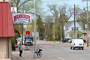
The areas around Como have busy roads and train tracks. But the main part of Como is mostly homes. You will see older bungalows from the early 1900s. There are also Victorian and 1920s-style houses. Some newer duplexes and single-family homes are mixed in. Along Como, 15th, and Hennepin Avenues, you might see two-story apartment buildings.
Most of the shops and businesses are on Como and East Hennepin Avenues. Along Como Avenue, you can find grocery stores and coffee shops. There are also restaurants and places for car service.
Who Lives in Como?
In 2020, about 6,455 people lived in Como. More than half of the residents have finished high school. Many have also earned a college degree.
Como is a diverse neighborhood. Many people who live here were born in other countries. Some residents speak languages other than English at home. The most common non-English languages include Spanish.
Most people in Como get to work by car. But many also use public transit. Others choose to walk, bike, or work from home.
| Race/ethnicity | ||||||
|---|---|---|---|---|---|---|
| 2000 | 2010 | 2020 | ||||
| Number | % | Number | % | Number | % | |
| White alone | 4,449 | 78.2 | 4,496 | 71.5 | 4,445 | 68.9 |
| Black alone | 312 | 5.5 | 622 | 9.9 | 747 | 11.6 |
| Hispanic or Latino (any race) | 168 | 3.0 | 203 | 3.2 | 399 | 6.2 |
| Native American alone | 70 | 1.2 | 104 | 1.7 | 51 | 0.8 |
| Asian alone | 540 | 9.5 | 638 | 10.1 | 740 | 11.5 |
| Pacific Islander alone | 3 | 0.0 | 1 | 0.0 | 0 | 0.0 |
| Other race alone | 15 | 0.3 | 25 | 0.4 | 27 | 0.4 |
| Two or more races | 134 | 2.4 | 187 | 3.0 | 380 | 5.9 |
| Total | 5,691 | 100.0 | 6,288 | 100.0 | 6,455 | 100.0 |
 | Kyle Baker |
 | Joseph Yoakum |
 | Laura Wheeler Waring |
 | Henry Ossawa Tanner |

