
Cooplacurripa River facts for kids
Quick facts for kids Cooplacurripa River |
|
|---|---|
 |
|
| Other name(s) | Number Two River |
| Country | Australia |
| State | New South Wales |
| IBRA | New England Tablelands, NSW North Coast |
| District | Northern Tablelands, Mid North Coast |
| Local government areas | Walcha, Mid-Coast Council |
| Physical characteristics | |
| Main source | Great Dividing Range southeast of Branga Plain, south of Walcha 1,270 m (4,170 ft) |
| River mouth | confluence with the Nowendoc River north of Gloucester 148 m (486 ft) |
| Length | 79 km (49 mi) |
| Basin features | |
| River system | Manning River catchment |
| Tributaries |
|
| National parks | Mummel Gulf, Cottan-Bimbang, Barakee |
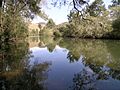
The Cooplacurripa River is a river in New South Wales, Australia. It's part of the larger Manning River system. This river flows through the Northern Tablelands and Mid North Coast areas. It's named after the small town of Cooplacurripa that it passes through.
Where the River Flows
The Cooplacurripa River starts high up in the Great Dividing Range. This is a big mountain range in eastern Australia. It begins near Walcha and flows mostly southeast.
Along its journey, it meets two other rivers. These are called tributaries. They are the Mummel River and the Walcrow River. Finally, the Cooplacurripa River joins the Manning River. This meeting point is near Gloucester.
The river travels about 79 km (49 mi). From its start to where it joins the Manning River, it drops about 1,120 m (3,670 ft) in height.
Life Around the River
The land around the Cooplacurripa River is mostly used for raising beef cattle. There's a very large cattle farm here called Cooplacurripa. It covers about 22,560 ha (55,700 acres) of land. This farm used to be owned by a big company called the Australian Agricultural Company.
The Cooplacurripa River is also known for its fishing. It's part of the Northern NSW Trout Waters. This means you can find trout in the river and its smaller creeks. This area includes all the waters upstream from where the Mummel River joins the Cooplacurripa River.
Images for kids
-
The Cooplacurripa River
