Cow Creek (South Umpqua River tributary) facts for kids
Quick facts for kids Cow Creek |
|
|---|---|

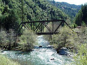
West Fork Bridge over Cow Creek
|
|

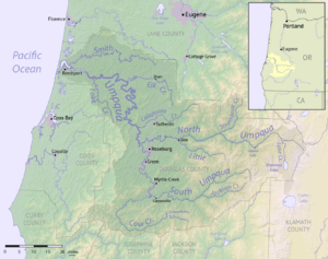
Map of the Umpqua River watershed including Cow Creek (the C-shaped watercourse near the bottom)
|
|
| Country | United States |
| State | Oregon |
| Physical characteristics | |
| Main source | South Fork Cow Creek A mile north of Round Top, Jackson County, Umpqua National Forest 4,000 ft (1,200 m) 42°43′34″N 122°59′44″W / 42.72611°N 122.99556°W |
| 2nd source | East Fork Cow Creek Richter Mountain, Umpqua National Forest 4,500 ft (1,400 m) 42°46′02″N 122°55′53″W / 42.76722°N 122.93139°W |
| River mouth | South Umpqua River Canyonville, Douglas County 636 ft (194 m) 42°56′49″N 123°20′16″W / 42.94694°N 123.33778°W |
| Length | 44 mi (71 km), East-west |
| Basin features | |
| River system | South Umpqua River |
| Basin size | 456 sq mi (1,180 km2) |
Cow Creek is a river in southwestern Oregon. It's a branch of the South Umpqua River. This medium-sized river collects water from a large area. This area is over 400 square miles (about 1,000 square kilometers). It includes parts of the Cascade Range foothills and the Oregon Coast Range. Most of the land drained by Cow Creek is in Douglas County. A small part is in northern Jackson County.
Where Cow Creek Starts and Flows
Cow Creek begins in the Umpqua National Forest. It forms where two smaller streams meet: the South Fork Cow Creek and the East Fork Cow Creek. The South Fork is bigger and is often thought of as the main starting point.
The River's Journey
- In its first few miles, Cow Creek flows west. It passes through a farming valley.
- It also flows through Galesville Reservoir, which is a lake created by a dam.
- For several miles, Cow Creek runs next to Interstate 5, a major highway.
- Near Glendale, Oregon, another stream called Windy Creek joins Cow Creek from the right side.
- The river then turns northwest and enters a canyon. Here, West Fork Cow Creek joins from the left, and Middle Creek joins from the right.
- Cow Creek continues flowing north. It then slowly bends eastward. It even doubles back, almost flowing in the opposite direction of its earlier path.
- Finally, the river leaves the mountains near Riddle.
- It makes a sharp turn south around a hill.
- Cow Creek then joins the South Umpqua River. This meeting point is about 2 miles (3 kilometers) west of Canyonville.
Black History Month on Kiddle
Famous African-American Activists:
 | Aurelia Browder |
 | Nannie Helen Burroughs |
 | Michelle Alexander |

All content from Kiddle encyclopedia articles (including the article images and facts) can be freely used under Attribution-ShareAlike license, unless stated otherwise. Cite this article:
Cow Creek (South Umpqua River tributary) Facts for Kids. Kiddle Encyclopedia.
