Crabtree, Oregon facts for kids
Quick facts for kids
Crabtree, Oregon
|
|
|---|---|

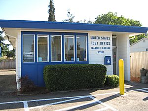
Crabtree post office
|
|
| Country | United States |
| State | Oregon |
| County | Linn |
| Area | |
| • Total | 1.81 sq mi (4.70 km2) |
| • Land | 1.81 sq mi (4.70 km2) |
| • Water | 0.00 sq mi (0.00 km2) |
| Elevation | 276 ft (84 m) |
| Population
(2020)
|
|
| • Total | 406 |
| • Density | 223.69/sq mi (86.35/km2) |
| Time zone | UTC-8 (Pacific (PST)) |
| • Summer (DST) | UTC-7 (PDT) |
| ZIP code |
97335
|
| FIPS code | 41-16350 |
| GNIS feature ID | 2584412 |
Crabtree is a small community in Linn County, Oregon, United States. It is called an "unincorporated community" because it does not have its own local government. It is also a "census-designated place," which means the government counts its population for the census.
As of the 2020 census, about 406 people live in Crabtree. The community has its own post office with a ZIP code of 97335. Crabtree is located about 10 miles east of Albany, near Oregon Route 226.
The community got its name from the Southern Pacific Railroad when the railway line reached this area. Nearby Crabtree Creek and Crabtree Lake were named after John J. Crabtree, an early pioneer who arrived in Oregon in 1845. He bought land near the Santiam River in 1846. The station and community were actually named for John Crabtree's cousin, Fletcher Crabtree.
Today, Crabtree has a fire station and a Christian church.
How Many People Live in Crabtree?
| Historical population | |||
|---|---|---|---|
| Census | Pop. | %± | |
| 2020 | 406 | — | |
| U.S. Decennial Census | |||
According to the 2020 census, 406 people call Crabtree home.
The History of Crabtree
Crabtree started to grow when a branch of the Southern Pacific Railroad was built in 1880. A train station was built where the railroad crossed the Santiam Wagon Road. This station was named Crabtree.
A post office was opened in Crabtree on February 28, 1887. In 1890, a resident named John Meyer built the first store in Crabtree. This first store later burned down.
The Crabtree Christian Church was started in 1909, and its building was officially opened on May 29, 1910. In 1913, William Turnidge, a well-known person in Crabtree, built a hardware store. This building later became a local gathering place until it closed in 2013.
In 1919, George Vana built a garage that operated as the Crabtree Garage until 1937. Later, the building was used as a barber shop. A new general store was built in Crabtree in 1923. This store was known as Knight's General Store from 1949 until it closed in 1975.
In 1973, Oregon Route 226 was changed. A new bridge was built over the South Santiam River, which meant the highway no longer went directly through Crabtree.
See also
 In Spanish: Crabtree (Oregón) para niños
 | Selma Burke |
 | Pauline Powell Burns |
 | Frederick J. Brown |
 | Robert Blackburn |


