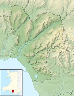
Craig Ty-Isaf facts for kids
| Location | Southern flank of Mynydd y Gaer near Baglan, Neath Port Talbot, Wales (OS Grid ref SS756933) |
|---|---|
| Region | South Wales |
| Coordinates | 51°37′31″N 3°47′52″W / 51.6254°N 3.7979°W |
| Type | Hillfort |
| Area | 0.2 ha (0.49 acres) |
| History | |
| Periods | Iron Age |
| Cultures | Celtic Brittonic |
| Site notes | |
| Condition | Banks and ditches within woodland. |
| Public access | Yes, but not on a path. |
| Designated | 1959 |
| Reference no. | GM263 |
Craig Ty-Isaf is an ancient place in South Wales. It's a small hillfort located near Baglan, in Neath Port Talbot. A hillfort is like an old fort built on a hill, usually for protection. Craig Ty-Isaf is one of three hillforts found on a hillside called Mynydd y Gaer, hidden within Briton Ferry Woods.
This hillfort sits on the southwest side of the hill, looking over Baglan. It's shaped like an oval and covers about 0.2 hectares (that's roughly half an acre). A wide bank made of rubble forms the main oval shape. On the east side, there are two more banks, making the whole site, with its banks and ditches, much larger. This important historical site is protected as a Scheduled Monument. Inside the hillfort, you might see some features that are actually from more recent times, possibly from people looking for minerals.
Contents
What are the Earthworks at Craig Ty-Isaf?
The earthworks at Craig Ty-Isaf are the old banks and ditches that make up the hillfort. They are located about 210 meters (or 690 feet) above sea level. The main enclosed area is about 65 meters (213 feet) wide from east to west and 45 meters (148 feet) from north to south.
The northern walls of the fort follow the top of an east-west ridge. This means the hillfort is on the higher part of the ridge, giving it a good view over Baglan to the south.
How were the Earthworks Built?
The oldest parts of the hillfort seem to be a complete oval shape made of rubble banks. These banks are about 2.5 meters (8 feet) high and 9 meters (30 feet) wide. A second bank runs along the east side, which is the uphill part of the ridge. This second bank seems to have been built at the same time as the main oval earthwork.
Originally, there was a gap through these first two banks that served as the entrance to the hillfort. Later on, a third bank was added further to the east. This new bank didn't have a gap, which suggests the entrance to the fort was moved to a different spot. This outer bank is straighter than the earlier ones. Because of this, the ditch between the banks changes in width, from 6 meters (20 feet) to 20 meters (66 feet) across.
You might also notice two other ditches inside the main area. These are not from the Iron Age but are actually from more recent mining activities.
Why is Craig Ty-Isaf Protected?
Craig Ty-Isaf was officially made a Scheduled Monument in 1959. This means it's a nationally important archaeological site that is protected by law. It was also listed in the 1971 inventory by the RCAHMW. This inventory recognized Craig Ty-Isaf as one of the 24 most important hillforts in the historic county of Glamorgan.
Can You Visit Craig Ty-Isaf?
Yes, you can visit the area where Craig Ty-Isaf is located. There aren't any specific footpaths that go directly across the hillfort itself. However, the entire area is part of the Briton Ferry Woods, which is managed by the Forestry Commission.
The woods are a mix of old broadleaved trees and planted conifer trees. There are several marked trails throughout the woods, and they are open for the public to explore. Craig Ty-Isaf is found on the southeast arm of these woods. Also, a part of the Wales Coast Path runs along the lower edge of the woods, about 200 meters (650 feet) south of the hillfort.
 | William M. Jackson |
 | Juan E. Gilbert |
 | Neil deGrasse Tyson |


