Crosslake, Minnesota facts for kids
Quick facts for kids
Crosslake
|
|
|---|---|

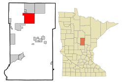
Location of Crosslake
within Crow Wing County, Minnesota |
|
| Country | United States |
| State | Minnesota |
| County | Crow Wing |
| Area | |
| • Total | 36.90 sq mi (95.58 km2) |
| • Land | 25.76 sq mi (66.72 km2) |
| • Water | 11.14 sq mi (28.86 km2) |
| Elevation | 1,240 ft (380 m) |
| Population
(2020)
|
|
| • Total | 2,394 |
| • Density | 92.93/sq mi (35.88/km2) |
| Time zone | UTC-6 (Central (CST)) |
| • Summer (DST) | UTC-5 (CDT) |
| ZIP code |
56442
|
| Area code(s) | 218 |
| FIPS code | 27-13978 |
| GNIS feature ID | 2393681 |
Crosslake is a city located in Crow Wing County, Minnesota, in the United States. In 2020, about 2,394 people lived there. Crosslake is part of the larger Brainerd area, which is known for its many lakes.
Contents
Exploring Crosslake's Geography
Crosslake covers a total area of about 36.89 square miles (95.58 square kilometers). A big part of this area, about 11.15 square miles (28.86 square kilometers), is water. This means Crosslake has many lakes and waterways.
Lakes and Waterways
Crosslake is a key part of the Brainerd Lakes Area. This region has almost 460 lakes within a 25-mile (40-kilometer) circle around the city of Brainerd. This makes it a popular spot for water activities.
A Look at Crosslake's History
The area where Crosslake is now started to grow in the late 1800s. This happened after the Pine River Dam was built in 1885.
Early Growth and Industries
The Logging Industry was very important in northern Minnesota at that time. Many of the first people who moved to Crosslake came because of the logging jobs. They helped the area grow and develop.
How Crosslake Became a City
Originally, Crosslake was part of Watertown Township in Cass County. In 1887, this township became part of Crow Wing County. Later, in 1951, the southern part of the township became Crosslake Village. The rest of it became North Crosslake Village in 1964. Both villages then joined together to form Crosslake Village in 1972. Finally, in 1974, it officially became the City of Crosslake.
Crosslake's Population Over Time
| Historical population | |||
|---|---|---|---|
| Census | Pop. | %± | |
| 1960 | 165 | — | |
| 1970 | 358 | 117.0% | |
| 1980 | 1,064 | 197.2% | |
| 1990 | 1,132 | 6.4% | |
| 2000 | 1,893 | 67.2% | |
| 2010 | 2,141 | 13.1% | |
| 2020 | 2,394 | 11.8% | |
| U.S. Decennial Census | |||
Understanding the 2010 Census
In 2010, there were 2,141 people living in Crosslake. There were 1,027 households, which are groups of people living together. About 651 of these were families.
Many households, about 56.9%, were married couples living together. Some households, 17.1%, had children under 18. About 16.6% of households had someone living alone who was 65 years old or older. The average household had about 2 people.
The average age of people in Crosslake in 2010 was 56.1 years. About 16.1% of the people were under 18 years old. About 34% were 65 years or older.
Education in Crosslake
Most students in Crosslake attend schools in the Pequot Lakes Public Schools district. Some parts of the city are also in the Crosby-Ironton Public School District and the Pine River-Backus Public School District.
Pequot Lakes High School is the main high school for the Pequot Lakes district. Crosslake also has its own school, Crosslake Community Schools, which serves students from kindergarten all the way through 12th grade.
See also
 In Spanish: Crosslake (Minnesota) para niños
 | John T. Biggers |
 | Thomas Blackshear |
 | Mark Bradford |
 | Beverly Buchanan |


