
Crowland facts for kids
Quick facts for kids Crowland |
|
|---|---|
 Crowland Abbey |
|

Crowland
|
|
| Population | 4,849 (2011.Parish) |
| OS grid reference | TF2410 |
| • London | 80 mi (130 km) S |
| Civil parish |
|
| District | |
| Shire county | |
| Region | |
| Country | England |
| Sovereign state | United Kingdom |
| Post town | PETERBOROUGH |
| Postcode district | PE6 |
| Dialling code | 01733 |
| Police | Lincolnshire |
| Fire | Lincolnshire |
| Ambulance | East Midlands |
| EU Parliament | East Midlands |
| UK Parliament |
|
Crowland is a small town and parish in Lincolnshire, England. It's located between the cities of Peterborough and Spalding. Crowland is known for its rich history, especially its old abbey and a unique three-sided bridge.
Contents
History of Crowland
.JPG)

Crowland has two main historical sites. One is the ruined Crowland Abbey, a very old church building. The other is Trinity Bridge, built in the 1300s. This bridge is special because it has three sides. It used to be where three streams met, but now it's on dry land.
Around the year 701, a monk named Guthlac came to this area. Back then, it was an island in the Fens, a marshy wetland. Guthlac chose to live there as a hermit, meaning he lived alone.
Later, a group of monks started a community here. They built an abbey, which is a type of monastery. This abbey was dedicated to Saint Mary the Virgin, Saint Bartholomew, and Saint Guthlac in the 700s.
The name 'Crowland' comes from old words. It might mean a "bend" in a river. This refers to a bend in the River Welland that was much bigger before the Fens were drained.
The town of Crowland grew up around the abbey. In 716, a king named Æthelbald of Mercia gave the abbey land. He also gave them money to build and protect the town. Many other kings later confirmed these special rights for the abbey.
The abbey became very wealthy. It owned a lot of land, and the monks helped farm the Fens. The town grew bigger because of the abbey's success.
A famous historical record, the Croyland Chronicle, was written here. It covers events from 1144 to 1486. Historians use it to learn about medieval times.
A big fire almost destroyed Crowland between 1469 and 1476. But the abbey helped its tenants, or renters, rebuild their homes.
The abbot, who was the head of the abbey, had a seat in parliament. This meant he could help make laws. However, Crowland itself was never a town that sent its own representatives to parliament.
In 1539, the monastery was closed down. This was part of a big change in England called the Dissolution of the Monasteries. After this, Crowland became a much smaller, less important village.
During the English Civil War in 1642, the abbey ruins were used as a fort. Royalist soldiers, who supported the king, defended it. But in 1643, Parliamentarian forces, led by Oliver Cromwell, captured it after a short fight.
In 1947, the area around Crowland had very bad floods. The River Welland and other drains couldn't handle all the melted snow. Today, a flood defense bank called West Bank still protects the village.
A railway line used to cross the area until the 1980s. There was even a train station nearby called Postland railway station.
Crowland's Government
Crowland is part of an area called an electoral ward. This ward also includes Deeping St Nicholas. In 2011, about 6,172 people lived in this ward.
Crowland is part of the South Holland district. This district helps manage local services for the area.
Geography of Crowland
Crowland is closer to Peterborough than to Spalding. It's just a short distance north of the border with the City of Peterborough. The main road that goes through Crowland is the A16. This road connects Crowland to Spalding in the north and Peterborough in the south. Other local roads connect Crowland to nearby villages like Deeping St. James and Thorney.
Crowland is in an area that needs special water management. It's part of the Welland and Deepings Internal Drainage Board. This board helps manage the water levels and drainage in the Fens.
Nature Reserve
North of the town, you can find the Crowland Ponds Nature Reserve. It's a special place for nature, located next to the west side of the River Welland.
Education in Crowland
Crowland has one school called South View Primary. It moved to a bigger site in September 2014.
The town used to have a secondary school called The St Guthlac School. It was named after the monk who founded the abbey. However, this school closed in 2011. Its students now go to the University Academy Holbeach in Holbeach.
Media in Crowland
People in Crowland can watch TV from different transmitters. These include Sandy Heath, Waltham, and Belmont. This means they can get channels from different BBC and ITV regions.
For radio, Crowland is served by BBC Radio Lincolnshire and BBC Radio Cambridgeshire. Other stations like Smooth East Midlands and Kiss are also available. The area also has a local digital radio service called NOW Peterborough.
The local newspaper for Crowland is the Peterborough Telegraph.
Images for kids
-
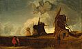
Drainage Mills in the Fens, Croyland, Lincolnshire by John Sell Cotman (around 1835).

See also
 In Spanish: Crowland para niños
