Cruser Brook facts for kids
Quick facts for kids Cruser Brook |
|
|---|---|

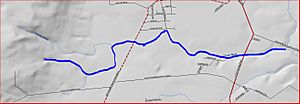
Map of Cruser Brook
|
|
| Country | United States |
| Physical characteristics | |
| Main source | 40°26′47″N 74°42′17″W / 40.44639°N 74.70472°W |
| River mouth | 52 ft (16 m) 40°27′20″N 74°39′4″W / 40.45556°N 74.65111°W |
| Basin features | |
| Progression | Pike Run, Beden Brook, Millstone River, Raritan River, Atlantic Ocean |
| Tributaries |
|
Cruser Brook, sometimes called Crusers Brook, is a small stream in Somerset County, New Jersey, in the United States. It's a tributary, which means it's a smaller stream that flows into a larger one. Cruser Brook flows into Pike Run.
Where Cruser Brook Flows
Cruser Brook begins its journey in a hilly area called Sourland Mountain. This is located at 40°26′47″N 74°42′17″W / 40.44639°N 74.70472°W. From there, the brook flows towards the northeast.
As it travels, Cruser Brook meets another stream called Roaring Brook. Roaring Brook joins Cruser Brook, adding to its flow. The brook then crosses a road known as CR-601, also called Belle Mead-Blawenburg Road.
After crossing this road, Cruser Brook continues flowing east. It then goes under a bigger road, Route 206. Finally, Cruser Brook empties into Pike Run. This meeting point is at 40°27′20″N 74°39′4″W / 40.45556°N 74.65111°W. From Pike Run, the water eventually travels through several other rivers before reaching the Atlantic Ocean.
Streams Joining Cruser Brook
Cruser Brook has one main stream that flows into it. This type of stream is called a tributary.
 | DeHart Hubbard |
 | Wilma Rudolph |
 | Jesse Owens |
 | Jackie Joyner-Kersee |
 | Major Taylor |

