Crystal Peak (Tenmile Range) facts for kids
Quick facts for kids Crystal Peak |
|
|---|---|

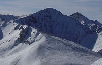
Crystal Peak viewed from Peak 8
|
|
| Highest point | |
| Elevation | 13,859 ft (4,224 m) |
| Prominence | 632 ft (193 m) |
| Isolation | 0.91 mi (1.46 km) |
| Geography | |
| Location | Summit County, Colorado, U.S. |
| Parent range | Tenmile Range |
| Topo map | USGS 7.5' topographic map Breckenridge, Colorado |
| Climbing | |
| Easiest route | Class 2 |
Crystal Peak is a tall mountain peak found in the Tenmile Range of the Rocky Mountains in North America. This amazing peak stands at 13,859-foot (4,224 m) high. Mountains over 13,000 feet are sometimes called "thirteeners."
Crystal Peak is located in the White River National Forest. It is about 5.9 miles (9.5 km) southwest of the Town of Breckenridge. This beautiful mountain is in Summit County, Colorado, United States.
Exploring Crystal Peak
Crystal Peak is a popular spot for adventurers. It offers stunning views of the surrounding Rocky Mountains. The mountain is part of the Tenmile Range, which is known for its beautiful peaks.
Hikers and climbers often visit Crystal Peak. It's a great place to experience nature. The air is fresh, and the scenery is incredible.
How to Reach the Summit
Most people who want to climb Crystal Peak start from the east side. This area is called the Crystal Lakes basin. It's a fun hike that follows old jeep trails.
These trails lead you up to the treeline. The treeline is the elevation where trees stop growing. From there, you reach Lower Crystal Lake. If you have a four-wheel-drive vehicle, you can usually drive this far.
A path on the north side of Lower Crystal Lake takes you to Upper Crystal Lake. After that, you'll find gentle scree slopes. Scree slopes are areas covered in loose, broken rocks. These slopes help climbers reach the ridges north of the summit.
 | Aurelia Browder |
 | Nannie Helen Burroughs |
 | Michelle Alexander |


