Curtis, Washington facts for kids
Quick facts for kids
Curtis, Washington
|
|
|---|---|

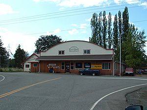
The Curtis Store
|
|
| Country | United States |
| State | Washington |
| County | Lewis |
| Elevation | 230 ft (70 m) |
| Time zone | UTC-8 (Pacific (PST)) |
| • Summer (DST) | UTC-7 (PDT) |
| zip code |
98538
|
| Area code(s) | 360 |
Curtis is a small community in Washington state. It's not an official city or town, but a place where people live together. Curtis is located a short distance north of Boistfort. It is also south of Washington State Route 6. The South Fork Chehalis River flows right through this community.
History of Curtis
A post office has been open in Curtis since 1901. It was located inside the Curtis General Store. Benjamin L. Curtis built this store. He was also the first postmaster, which is the person in charge of a post office. The community was named after him.
When Curtis was first settled, its economy was based on two main things: logging and farming. Logging means cutting down trees for wood. Farming here focused on growing hops. Hops are plants used to make beer and other things.
The Klaber Hop Fields (Farm) used to be in Curtis. This farm was very large, covering about 360 acres. For a time, it was known as the biggest hops field in the world. It stretched across Curtis and nearby communities like Boistfort and Klaber.
Arts and Culture
Historic Places in Curtis
Curtis is home to two places listed on the National Register of Historic Places. This list includes important historical sites in the United States. The two places are the Boistfort High School and the Wolfenbarger Site.
Education
In the past, Curtis had its own two-room schoolhouse. Today, students from Curtis attend schools in the Boistfort School District. They go to the Boistfort Consolidated School.
See also
 In Spanish: Curtis (Washington) para niños
 | Emma Amos |
 | Edward Mitchell Bannister |
 | Larry D. Alexander |
 | Ernie Barnes |


